

August 2022
Pidmo – Parfi la – Yichen – Dibling – Pudzong la – Kanji la – Kanji
Hidden behind high ranges and completely closed of from the rest of the world in the winter months lies Dibiling. This small Zanskari village had attracted me from on the first time I heard about it. The first time I visited Zanskar it was however one of my first ever treks and this back then this route had simply looked too difficult for a first timer.
However with my plans to cross Poat la and Umasi la shot dead, I got a new chance. Rather unprepared I therefore started this trek with Eline from Pidmo to Dibling and then on to Kanji. The part around Kanji I had prepared since I had wanted to cross from Rangdum to Kanji across the Kanji la after comming down from Umasi la. But on the route from Pidmo to Dibling and accross the Pudzong la we would need to follow by eye.
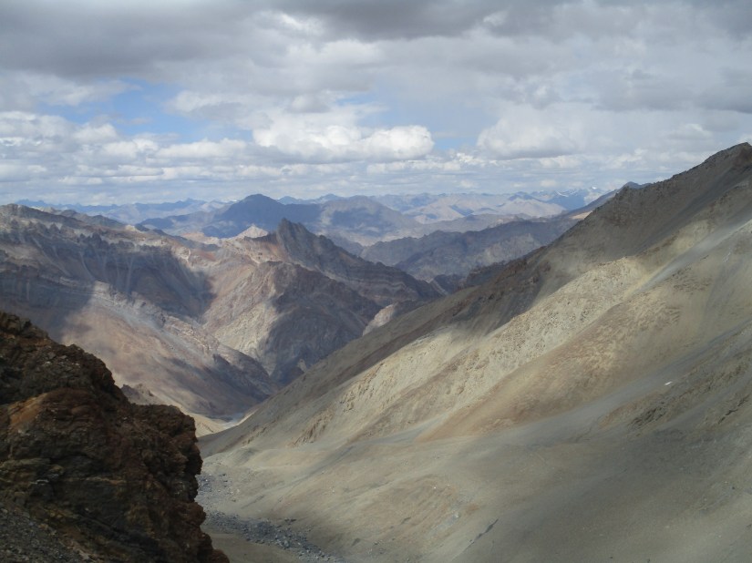
With the rampant road construction, this trek is, at the time of writing one of the last remaining long distance treks in Zanskar. It offers an amazing route from the Zanskar valley to Ladakh combining wild mountain scenery and trails with cozy villages along the way. There are multiple rivers to be crossed and the trail is at times extremely narrow and slippery. But the trek is nowhere technical. Route finding is rather challenging from time to time.
This trek offers all that Zanskar is known for. Steep cliffs, colorful rock, tiny villages, Tibetan culture, high passes and many yaks. Having done several treks in Zanskar I must admit this is probably my favorite one. It has the views and wilderness of the Gotunde la, but it combines it with a cultural dimension that you used to find along the classic Darcha to Lamayuru trail.
How to get there
Leh is easily reachable, either by bus from Manali or by plane from Delhi. Padum is harder to get to, but nowaday it has many roads leading to it. You can get a shared taxi from Leh, Kargil or Manali. It does usually take a full day to reach here. From Padum it is about 1 hour by private taxi to reach Pidmo, the starting point of this trek. From Kanji you need a private taxi to get you to Lamayuru from where you can take the 2pm bus to Leh, or you can take a taxi all the way to Leh.
Season
Don’t even think about completing this trek in winter. July to mid september are best. June and late September are usually ok as well. The climate in July and August is really pleasant, even a bit too hot during the day.
Packing list
Leave your technical gear at home and just pack the camping essentials. In Dibiling Hanumar and Yichen you can get a homestay, but you will need to press for this as there is nothing commercially available. Mind that the old tea tent you used to find after the Parpi la is no longer in operation (it is only occasionally there in case of big groups). Yichen is a good alternative, it is about 40 minutes up into the canyon from the old tea tent. (When climbing along the narrow canyon it is hard to imagine that people are living nearby, but this is actually the case). Even though you have some modest access to home stays I would carry at least 5 days of food.
A GPS and good map are great to have, as the trail is not always clear. It is clear most of the time and if you have an idea of the route you can follow it by eye, but there are some confusing points along the way.

Videos
Day 1
We had resupplied in Padum and were in a taxi to Pidmo at the very northern tip of the Zanskar valley. We made a stop over at Zangla to visit the palace. A nice monument overlooking the valley from a hill top. Apparently it was here that the King of Zanskar lived and the first Tibetan to English dictionary was written.
Nowadays Zangla is just a small, traditionally built village and Padum has taken over as the capital of Zanskar.
About half an hour further we crossed the bridge over the Zanskar village to Pidmo. Here the trail followed the western bank of the river, where to road followed the eastern side. It seemed rather silly, we had to walk about 12km before we would divert from the river, but since nobody had constructed a bridge we already needed to start hiking from here.
As we hiked through the fields of Pidmo I started to realize that our plans might be a bit too ambitious. Most people stay overnight in Hanumar. A settlement of two houses, falling a bit short for the title of village. But we wanted to continue on and cross parfi la to stay overnight in a tea tent on the other side of the pass.
The route was for Himalaya standards rather flat and we made quick progress, 12km however through mountainous terrain is just far and we had to press on to make sure we would arrive there before sunset.
We passed Hanumar and took a small break to cook some of our noodles. We cooked ourselves as there was nothing along the trail. No small shop, no tea houses, no nothing. If we would have wanted to stay overnight we could surely get something done, but with nothing commercially available you are not going to haggle about lunch.
It must have been different in the past. This used to be a world famous long distance trek. But it has been slowly dying for years with the road construction eating out more and more of the trek. A few years back the road was completed and COVID probably gave the last stab. It was that the Israeli had told us that a tea tent was available just over the Parfi la, otherwise I would have started to doubt it.
About 2 hours from Hanumar the climb to the Parfi la started. The climb was a lot longer then I had anticipated (wishful thinking from my side). It was a few tiring hours up with heavy backpacks. Wico had left his water bottles in Padum so we quickly got thirsty again. We were lucky to spot an empty bottle next to the trail, otherwise the lack of bottles might have formed a problem for us later on. Zanskar is hot and streams can by times be few and far in between.
The sun was already setting when we made it to the top. A beautiful red light illuminated the enormous cliffs around us. We rested for a moment. We could already see the stream where the tea tent was supposed to be below us. We would make it before sunset for sure.

After a small rest we made a swift decent. We now left the large Zanskar river behind us and with that our last view on the road. The terrain and nature around us immediately started looking more remote and secluded. As we marched down it become clearer that there actually might not be a tea tent. There were two half ruin houses, but we did not see any smoke. Not a good sign.
We were tired and thirsty so it was quite the disappointment when indeed the place turned out to be deserted. It ate away from our confidence immediately. Wico started to wonder whether he should press on to Lingshed or turn back the same way. There was no one on the trail and it was still a long way, with an over 1400m ascend. I myself saw the trail we needed to follow following the stream westward. The trail seemed extremely narrow and it felt like it would run into a dead end between the steep rock and the gorging stream.
The next village Dibiling was still 30km away, I had no real knowledge of the route and we would need to already start eating our supplies as no tea tent was around. What I knew about the route (from some research I did almost a decade ago) the trail would follow the bottom of a steep canyon and bore some danger in getting impassible enduring flash floods. Judging the trail it felt impossible that somewhere between here and 30km the trail would somewhere have been washed away.
I could not resist but to follow the trail, to explore what would be coming. Otherwise I would just worry all night. As I followed the narrow trail, it quickly became a climb via steep rock each time narrowly avoiding the wild stream. In about 10 minutes however I could see the rock easing further up stream. This reassured me somewhat, maybe it would get better further on. I retraced my steps to Wico and Eline who had started to get a bit worried.
We camped in one of the houses, that was clearly used as a tea house from time to time. It was a great place to camp out. There were some plastic chairs, good drinking water, some fire wood and immense cliffs rising up all around us. The rock heated by the sun remained warm so we could sit outside around the campfire. I made paste with tuna. I made too few to still our hunger. I felt compelled to, since we were eating now with 3 people whereas I had expected that tomorrow would be the first night in the wild and only with 2 people.
Day 2
We made a very early start. Wico was going to head back to Pidmo with only little water and wanted to make sure he would have crossed the pass before the afternoon heat would start. Eline and I would also get on for an early start since we wanted to reach Dibiling the next day. Meaning covering 30km in just 2 days, which is for Himalaya standards rather ambitious.
After our oath meal we waved Wico good bye and retraced my steps of the previous day. The first part was indeed a bit iffy and left you wondering about what lay ahead. But after about 20 minutes the terrain eased out. The easing terrain did mean that the trail was harder to spot. The fact that I did not have this route in my satellite phone and was pretty much just navigating by the eye without any real knowledge about what the trail would be up to. The only thing I knew was that we needed to follow the stream up and that Dibling lay 30km further. That’s it. I had wanted to get some local advice from the tea tent, so that I at leas had something to go on. But yeah that tea tent turned out to be not there. So the situation did make me a bit anxious. Who knows maybe Dibiling would also be deserted…
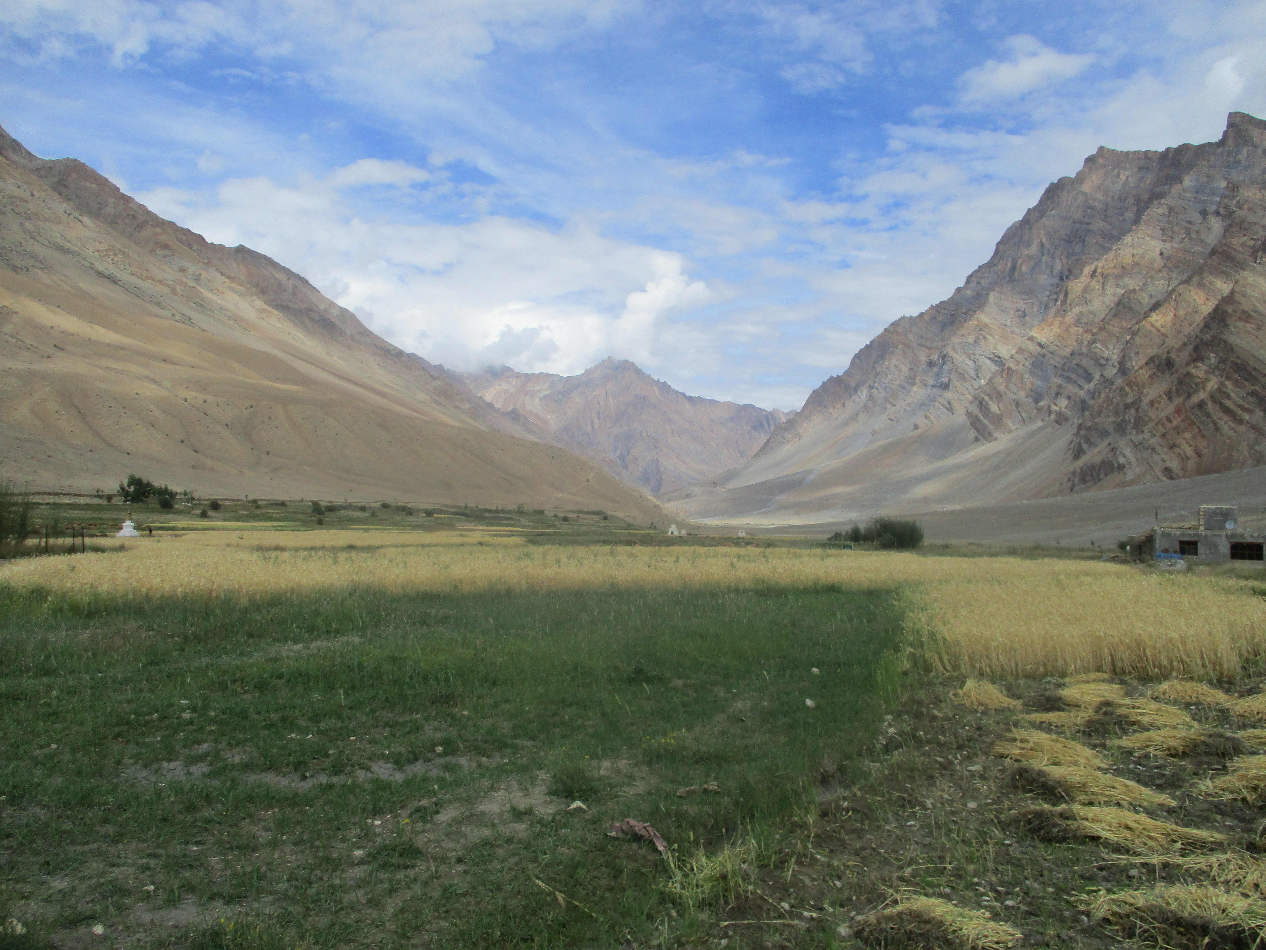
Much to our surprise we stumbled on an old wheat field. Who had ever used this land here as farm land? It was far from any village and very hard to get to… Even more to our surprise we found a field full with wheat a bit further. Wait… Somebody actually traveled here to sow wheat? A bit further the mystery solved itself, as we stumbled on two houses. There were actually two families living here! I had not known or suspected this… What a nice surprise! I immediately took the chance to buy some local sampa and ask for directions. (A fatal mistake as it would turn out days later).

The young man pointed us in the direction of the trail and assured us a good route to Dibling. This lifted my spirit significantly. The extra assurance was pretty welcome as from this point we needed to ascend a few hundred meters again. I had thought that the trail would follow the bottom of the canyon, but for the rest of the day we climbed way up and down to traverse the steep cliffs.

It was tough and the trail by times extremely narrow and slippery but the views were amazing. There was very little water to be found along the trail and at around 3pm we stopped at some shrubberies with a very small stream. The stream was so small that it literally took 2 minutes to fill up a water bottle, but at least there was some water.
We made a campfire as we saw the sun setting behind the mountains. After all the rain we faced around the Kang la we could really enjoy the warm and dry rocks of Zanskar.
Day 3
We expected that the trail would meet up with the river below soon and that hiking would get easier. But, of course, this took longer than we thought. We spent several hour more ascending and descending the cliffs rising high up from the river below us.
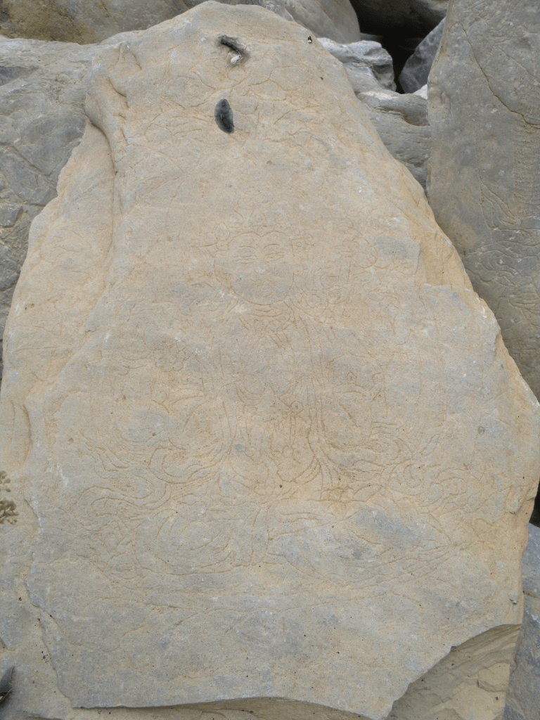
We had to pay attention to keep track of the trail, but it was never gone for long. Around 1pm we finally saw the descend down to the river. The cliffs eased and made way for meadows. We descended about 200m down. It was clear that people visited this place with their cattle every once in a while. We could see stone man, Mani walls with Buddhist inscriptions and some deserted stables and houses.

Once down we had lunch in the shade of some trees. It was tempting to stay here, but Dibiling was still 15km away. Quite far in mountainous terrain. So we had to press on for at least another 3km.
The problem with all the traces of people and cattle was that the main trail was not so clear. As we hiked along the river the trail got fainter and fainter. At some point the terrain got so steep that I left my backpack behind to climb further to see what lay further ahead. While I was climbing I wished I had not done it, I was really scared do fall down and into the river. On the other side of the river I could make out a trial. There was a wobbly bridge where we had taken lunch, so maybe we would need to cross? We went back to check the bridge out.
Back at our lunch spot it had already gotten late and we were not sure what way to go. We decided that Eline would setup camp and I would explore the other side of the river.
I have seen a lot of primitive bridges in my life. But this bridge was iffy even by my standards. Just some iron wire with some branches. There was absolutely no way mules would be able to cross this. Would they cross the river I though by myself? Looking at the water it seemed unlikely. I hail married across. There was a large and clear trail on the other side, but since the bridge was so sketchy I did not trust the situation. I followed the trail all the way till I could see Eline again at the camp site. The trail kept continuing and it felt like a real route. But still how would parties with mules do this?
Above the campsite I saw a few trails in the stone. It was not one trail but many smaller trails following the contour of the mountain. Many parallel trails usually means grazing animals have made them. Humans tend to form one large trail instead of multiple at even intervals next to each other. Still I felt I needed to check it out, we needed to know for sure which way to follow tomorrow.
Getting back to the campsite actually took over 30 minutes and the sun was already starting to set. As I checked out the route above the campsite I quickly realized this was the real route to Dibiling. It had been so close! We had just missed it by 40 meters. The trail climbed slowly up where we had kept following the river. To make sure it was the way I followed the trail all the way to the steep rock I had almost fallen down from earlier. But the further I got the more sure I got.
Content I went back to camp to enjoy the last light of the day. We had a route for tomorrow! Eline had placed the tent on a nice patch of grass and the weather was nice and warm. Zanskar really makes up for some of the best camping in the world.

Day 4
We rose early. It was a long way to Dibiling and we had no idea what lay ahead. Hopefully we would not lose the trail again… We took the route that I had found yesterday and made quick progress.
The trail was way easier than it had been the previous 2 days. There were small ups and downs but the trail overall just followed the river. It was quite beautiful to walk below the high rocks along a narrow river bank. Sometimes the trail was built right up a rock face. This is how I had imagined the route to Dibbling would be.

We came across to nice bridges avoiding the steep section on the norther bank and had to wade through a side stream.
At noon the valley widened again as we stumbled on a herd of yaks. Maybe they were from Dibiling? With only 8 more kilometers to go it did not sound unlikely. We had some lunch in the shade. (Between 12 and 3pm it was just insanely hot in the Zanskari sun)
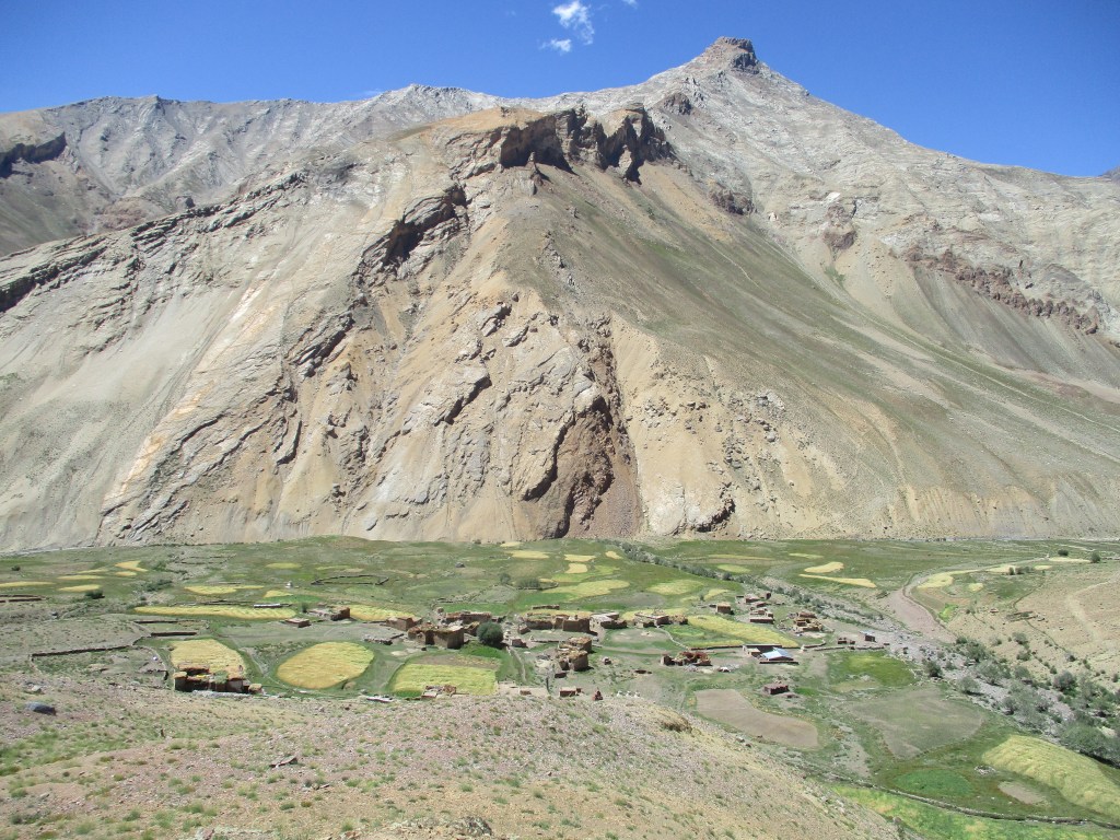
When we finally got the first glimpse of Dibling it was already 4pm and we were tired. At first we could only see 2 ruins. I wondered, Dibling was supposed to be a real village, small, but a real village nonetheless, what we were approaching looked more like 2 abandoned shacks… Only when we were there we could see the actual village lay just out of sight behind a ridge.

I was delighted. It was really beautiful to see. Traditional hand made houses in the middle of the yellow fields. It took us some effort to arrange a home stay, but in the end a local referred us to the local school master who set us up with a welcoming family that made a room available for us.

Day 5
Disaster struck… When I wanted to pay the family for our stay I noticed that my money bag was no longer in my bag. Our money was gone! Worse… Our passports were gone! It was panic time. At first we could barely believe it. But we stripped the bags time and time again and they were indeed just gone.
We started to think back. I could clearly remember that they were in our bags when we said goodbye to Wico. Since then we only took it out to pay for our Sampa in Yichen. As a matter of fact, if we lost it, and that is the case. It must have been there.
The more I thought about it, the more I was convinced it had to be there. The only catch was that Yichen was 3 days away, or ok 2 days if we marched on. Maybe 1 long day could be done if I would do it alone without backpack.
But were we sure enough it was there? Could we find it again? We were super lucky that someone in Dibiling was family of the people in Yichen and that both places had mobile reach. They called for us and confirmed that our bag with passports was indeed found. Even better they had made an agreement with them that the next day they would start hiking towards us. We would do the same from our side and meet in the middle for a hand over. If we left early enough we could make it back to Dibling the same day.
We were super relieved that the situation worked out this way and we spent the next of the afternoon simply being relieved that the worst case scenario had not come true. It would have been such a lengthy procedure to get papers in order to leave India again. I would not even know what the procedure would be.
The rest of the day we spent around the village. With hind side I’m happy we got to spent the time here. Dibiling is a wonderful place with nice people set in a dramatic landscape. It was also a great opportunity to eat and learn more about the Tibetan cuisine.
Day 6
I woke up around 4:30am when the starts were still out. I was the first one up. Being up this early made me realize that we occupied the room of the grandmother in the house… She was sleeping outside on a small mattress… I thought it would probably best not to tell Eline as she would feel bad.
I left with two of the town folk at the first hint of sunrise. We hiked swiftly and took 2 hourly rests to take some tea or biscuits. We made very quick progress. I was amazed how fast we went. Without a backpack is considerably easier than with. The guy who would walk towards us actually had the tougher job as he needed to cover the same distance but with big ups and downs.
Between 10 and 11 we reached the agreed upon location. Actually our campsite of the 2 days before. I had thought we would be the first ones there, but the guy from Yichen had actually outrun us. We had some noodles and tea and exchanged some pleasantries. All the time I just really wanted my passports back, but we had to sit through a bit of chitchat first of course.
When I got my passports and money back a split the money in 2 and gave half back as a finders fee.
We got back to Dibiling around 3pm, earlier than Eline had expected us back. We spent another nice evening around Dibling and prepared for the last days of the trek in front of us.
Day 7
It would be an easy and short day. Crossing Pudzong la in 1 day sounded like overstretch, but the base of the pass was just 3 hours away, so we would just need to hike slowly…
We left after breakfast and followed the river upward. There was Yak shepherd tent when the rivers split up. Here all the Yaks of Dibling spent the summer. The Yaks we had seen further downstream were of the people in Lingshed.
We waded through the river and hiked further up. From here on the route was not so clear anymore. There were small trails on either side of the river. We tried crossing the river, once we crossed the other river bank looked better after all.
As we crossed back after a short while we met a local assuring us that this side was indeed the best. The local came from the small shacks a bit further on. I was surprised to still found houses at this point. They looked like seasonal houses, not equipped to withstand the harsh Zanskar winters.

We hiked on for another hour and quickly got sight of the base of the Pudzong la. We procrastinated by having a long lunch and rest. But we did end up arriving early at our campsite. The climb to Pudzong la is rather steep and goes pretty much straight up. So we could not really press further as it would be unlikely for us to find fresh water further up.

Day 8
We rose early as we wanted to push all the way to the base of Kanji la, quite a distance away. The trail up the Pudzon la was not really clear at the start. But it was quite clear we would just need to climb the gravel slope so we just decided to follow the empty bed via which in heavy rain probably would come down. As the going got tougher we climbed out of the river bed and started to scramble up the gravel slope.
Not long after we found the actual trail back, it was not big, but unmistakably it was a trail leading up to the pass.
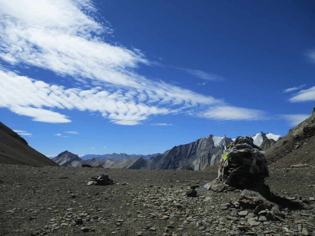
The Pudzong la does not hold great views, mostly because after a long climb the terrain flattens out for a long time and actually curves while slowly climbing up. But view or not we were happy to sit on the top. This was our first 5000 plus meter pass in Zanskar and we were satisfied seeing the stone pile and flags marking the pass itself. We hiked 100 meters further over relatively flat terrain to sit on a good stone and enjoyed some of the nuts we had brought.
15 minutes later wa saw, much to our surprise, another group of trekkers climbing up the pass via the other side. It was a group of Korean trekkers accompanied by a couple from Swiss and their Ladakhi crew and Nepali guide. We had a small chat with the people from Switzerland. They had at first wanted to do the Lamayuru to Darcha trek that the husband had done years back. However upon hearing that the Lamayuru to Darcha road had been completed by now they had changed plans and taken this new route. I was quite happy to see that people were finally abandoning the classic Lamayuru to Darcha trek for more up to data alternatives. Lamayuru to Darcha had indeed once been one of the greates treks in the world, but one has to adapt and the best trek in the nineties is simply not the best trek in the twentieths anymore…
We hiked down. The descent was very gradual, even slow. We simply had to hike down a bit over gravel and then follow the stream down. As we descended the stream became larger and carved out a small ravine for itself. There was no trail but we just followed the stream via the bottom of the ravine and were every now and then encouraged by an either or not imagined stone man.
At some point the ravine narrowed and the stream fell through as a waterfall. It was pretty clear that this was not the official route anymore. We backtracked our steps looking for clues. On the south flank of the ravine we found a small stone man and a clear trail leading out of the ravine. It was not easy to spot and we had hiked past it at first, but it was clear that this was the right way to go.
We made quick progress and it looked like we would make the base of Kanji la easily. However as the stream became a river and we were hiking over the meadows we came at a major side stream. Or stream… At the moment more a powerful mountain river… We could see the glacier it originated from just 4km further up, yet the river was already too powerful to safely cross. I tried a few locations, but even with a rope it would be a difficult endeavor. Ever since the Pakistan incident I have grown more cautious around rivers and we decided to just pitch our tent and wait for the morning. It was clear that we were on the right spot and we knew for sure that the trekkers we had just met in the morning had to somehow have crossed this river. It seemed unlikely in the moment, but in the morning the water levels should be low enough to just cross it.
Even though we were almost sure that we were in the right place and people had crossed yesterday it felt uncomfortable to be blocked by a river. I regularly walked to the river to check the water levels. In the evening I indeed got the feeling it was subsiding a bit, but it was no where near easily crossable yet. Even in the night I woke up twice to see what the water was doing. The second time I woke up I was very pleased to see that the river had shrunk to only a fraction of it’s original size.
Day 9
We woke up at first light and crossed the side river first thing. It was now an easy and narrow knee deep stream. Unbelievable what the difference in water levels between different times of the day could be.

After crossing we pressed on as we knew we would likely need to cross the river again. We wanted to be quick as at this point the river would be much larger as it would have merged with 3 other major streams.
It took us about 1.5 to 2 hours to get to the next crossing point. We were a bit in doubt whether we had to already cross as the trail on our side of the river continued further on. But the trail would probably lead to Rangdum, probably there would be another crossing point as well to take people quickly from Rangdum to Kanji, but for my part we should cross the river sooner rather then later.
Once across we could finally sit down and relax for a moment. We made breakfast and looked ahead. It seemed like a good decision to have crossed the trail on this side was way more direct it seemed.
We did not take a lot of time to take breakfast since we wanted to cross the Kanji la today, which was still far away and still way further up.
The climb to the Kanji la resembled the descend of the Pudzong la. We first had to follow a narrow canyon carved out by a small stream. After a while the stream disappeared under gravel and boulders. The canyon disappeared as well and from now on it was a tough and long climb over boulders all the way up to Kanji la.
Strangely enough there was a rather clear trail over the gravel visible. You would not say that a trail would remain visible in this kind of terrain but yet it did.

It was a long climb and steeper than it looked. We made slow progress but progress non the less. Kanji la would be the highest point we would reach in Zanskar and from the view over the Zanskar and Himalaya range in the south we could clearly see we were getting pretty high.
In the end we made it all the way to the pass. The view was simply amazing, both to the south where we came from but especially towards the north. In the south we could see the glaciated Himalaya peaks and north of us the endless brown and barren peaks of the Zanskar and Ladakh ranges. Far up north you could even see the steep and snowy peaks of the Great Karakoram range. We spent a lot of time on the pass gazing towards the north and the seemingly endless peaks we could see stretching out till the horizon.
The first section of the descent from the pass was extremely. It was about a 70 meter drop to the glacier below. We had to be quite careful not to slip. Once on the glacier the terrain got flatter, but not directly easier. Trails do not from on glacial terrain and it was hard walking over the loose terrain. We could however clearly see a good trail further on that would take us all the way down.
Once on the good trail we could walk swiftly again, but the day had already been long and it seemed the trail would keep altitude for a while after which we once again would need to go up before truly descending. We decided to camp at the first good spot. We had filled up our bottles on the glacier so that we could stop basically at any flat enough spot.
We camped about 1 hour further on a flat hilltop nicely overlooking the valley. We enjoyed a peaceful evening, but unfortunately the peacefulness did not last and later in the evening we faced a storm with hard winds a heavy rains. The first truly bad weather we had faced in Zanskar.
Day 10
Today we had to reach Kanji. There was no question about it. If we would not reach it today we could very well be at risk of losing our flight back from Leh to Delhi. But getting to Kanji sounded pretty feasible so we were not worried. The worst thing that could happen was that the river down would again become not crossable during the afternoon, so an early start was nonetheless desired.
The day started with a small climb to the saddle point we could see from our camp and then a very sharp drop all the way down to the river. There was no trail along this river, but we knew we just had to follow this river down till we would see the village Kanji itself.

It was a really nice final section of our trek. We hiked through a beautiful deep canyon and every now and then had to cross the river. At first we could do this by hopping from stone to stone, but later on the shoes had to come off and we had to wade.
Everyone probably used his or her own trail in this section as there were regularly some traces of past trekkers, but seldom an actual visible trail.
After a while the landscape opened up a bit more and we came accross the first Yak shepherd since Dibling. He greeted us cheerfully and indicated that Kanji was not too far away anymore. At this point we knew that we had crossed all major obstacles and that not much would stand between us and Kanji anymore.

We came past one last great viewpoint. A large flat area where three valleys came together. You could look deep in each valley and of course a small hut with 3 yak and goat shepherds stood in the middle. We made a short stop to greet them. We gave them some bandage to help with a wound on someones feed and got some great farm fresh yogurt in return.
From this point on the river had gotten knee deep and we had to cross it several times. We were pretty near Kanji at this point, but the constant river crossing made it a long journey nevertheless.
Kanji where we now ended our trek was the same place as I had started my Zanskar trek in 2010 (what was maybe my first real Himalaya adventure). It brought back a lot of memories and I could recognize the mountains and monastery very well. The thought that I could now make up for the photos I had lost almost a decade ago made me laugh.
Aside from what had remained the same I also saw a log of new things. The village had clearly grown a lot and the trail we had taken up towards Kanji dok was now a road.

At the end of the village we found a small family run hotel. The daughter of the owner had just arrived from Leh and spoke quite good English, making a conversation easy. She said that tourism since COVID had still not recovered but that it was not too bad as the village was more or less self sufficient. She also told it that she for the world of her could not understand why people all over the world would travel here to undertake long and arduous treks across boring mountain terrain. I could not really explain to her why I had wanting tom come so bad, but would surely want to come once more 🙂 Newly constructed roads or not, the northwest of India is a world class destination for adventure tourism.

