

August 2023
Illulisat is to Greenland what the Eifeltower is to France. It’s the number one destination and probably the first thing that people think of when thinking of the country.
When planning my trip to Qaanaaq and noticing that I had to make a stop over at either Upernavik or Illulisat I did not doubt to seize the opportunity and plan a small side trek in the region.
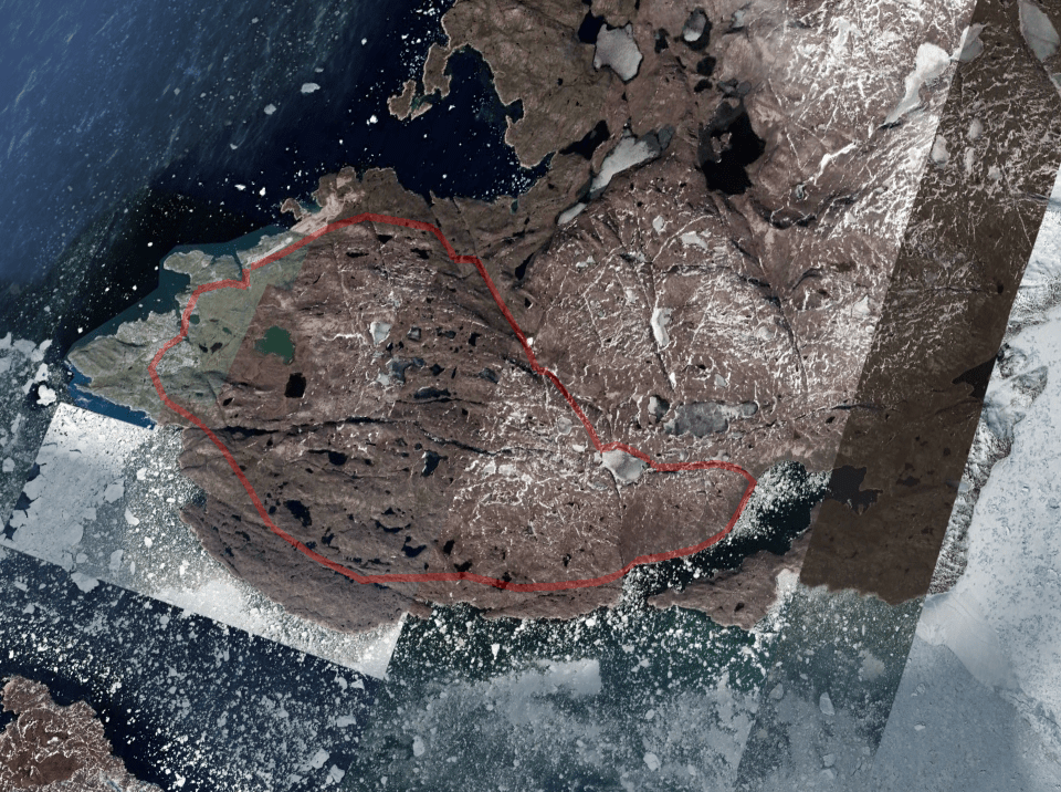
Illulisat translates to ‘Ice berg’ and is famous for the enormous icebergs that can be found in the the bay as well as the completely ice covered fjord starting at the Sermeq glacier. One of the fastest calving glaciers in the world.
Due to it’s fame I always wondered how it would compare to the Sermilik fjord in east Greenland. Though it is said the ice bergs in western Greenland reach higher sizes than their east Greenland counterparts I must say that I could not make out this difference by the naked eye. Despite the fame of it’s immensity it did not feel as a different scale to what I had seen in eastern Greenland. Though I’m sure that when you do the actual measurement there is a big difference. I guess at some point a very large chunk of ice is just seen as a very large chunk of ice by the senses…
The route I wanted to take was pretty much established by a first glance over the map. Hiking along the ice fjord was a no brainer, and since we did not want to go back the same way there was only really one route possible.
It is of course the most touristy destination within the Greenland, however this is still by Greenland standards. Sure half of the buildings in Illulisat are tourist hotels and restaurants, but it still feels like a genuine polar destination. The fact that flights were constantly delayed or cancelled due to the weather made sure people did not forget that they were right in the middle of nature. An international all weather airport was being constructed while we were there, so maybe things will change over time.
Packing list
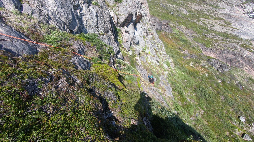
It’s just an overnight hike (though taking 2 nights would have been better) for that reason I would recommend only taking the bare minimum. The terrain involves stretches of steep terrain and a few snow fields but no technical gear is needed. If you are doing the exact route I did there will be a very steep section of rock along the fjord, a rope adds some safety here.
How to get there
Illulisat is the number 1 destination in Greenland, flying here is easy to do. As of this writing you still have to fly to Kangerlusuaq first and transit to Illulisat after that. But in the near future, when the international airport is finished, there will be direct flight to Illulisat as well.
Season
This trek is best done in June to September, when everything is free of snow. Though during the winter time I’m sure adaptations of this route would be very suitable for ski or sledge adventures.
Keep in mind that the end of July is prime mosquitoes season. We managed to be there right in the peak. They are an absolute pest, it’s definitely the worst mosquitoes I have ever experienced. Just relentless clouds that drove us into our tents. Even along the seaside they were really bad.
Alternatives
If you have more days to spent you can enlarge the circle and hike longer along the fjord and mainland. However whichever trek you are planning you are likely to end up with hiking along the fjord and then through the hills or the other way around.
Videos
Day 1
We had arrived the previous day and set up camp right next to the airport. This is one of the things I love most about Greenland. The airport you land on brings you directly in the middle of nature. Camping next to the airport gives you a camping spot you can only dream of in most places.
Our camp spot was no exception to this rule. We could look out over the great Disko bay with Disko island in the far distance (even though it looked deceptively close). The weather had been great and we had even spotted a whale from our tents plus a collapsing ice berg. We basically had the whole Greenland experience right next to our port of arrival…

The only downside was that the city Illulisat itself was 5km from the airport and we had to hike up and down to get our fuel… The rest of the day we spent sorting our food and creating a food depot for when we returned. our main trip would be a 17 day long trek in the Qaanaaq region, we would only need to take 2 days of food with us for this trek.
The morning of our departure was in stark contrast with the day before. A fog had set in (something that would become all to familiar during this trip). It’s quire unusual to have so much fog in western Greenland, the locals thought that this year might be different due to all the forest fires in Canada.

Fog or not, we got on our way. We could follow a trail for a few kilometers, but after a while we had to follow a side valley up to head towards the ice fjord. The hiking was quite strenuous due to the uneven terrain, but not problematic. The thing that was problematic were the mosquitoes… They would just not leave us alone, if you were just as much to slow down a little they were all over you.
As we hiked I began to realize that doing this hike in just 2 days might have been a little to ambitious. Sure it could be done, but with just one night there would not be much room for error. And errors are the thing one should expect when out in the wilderness…
Of course we ran into an issue as well. Once we made it to the lakes at the highest point the terrain tempted us to go off the planned route and follow the easiest path. However due to this we were pushed much further north than was the plan. So by the time we set up camp I realized that we had to hike quite a long distance the next day. Our flight to Qaanaaq would depart the next day, so I was already starting to regret my tight schedule. My navigation error had meant that we had to hike 3.4km extra the next day over terrain I was less familiar with and the descend to the fjord looked quite steep.

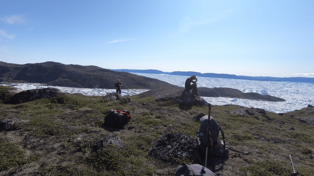
Rose went on to explore the route down to make sure we could reach the fjord and hike along the coast line. We were happy when she returned with good news. Now we could start and enjoy our first night in the back country! The weather had completely cleared over the day and we could enjoy good views over the ice in the fjord and glaciers far west of us.
Day 2
Due to our flight to Qaanaaq the next morning we had to hike back all the way to Illulisat today. Which to be frank was not as easy as I had thought it would be. The terrain was quite tough for most of the way, the first section of today was no exception. We kicked off with a steep descend from our camping spot down to the sea. A descend that was at some points almost a climb. Once down we followed the coast line, often heading up to traverse steeper sections. Though the going was tough the weather and the views over the ice fjord were amazing. I would not have wanted to miss this hike, I only wished we had an additional day to relax along the fjord shores. However, due to the literal clouds of mosquitoes I don’t know if we would have enjoyed it as much as I imagine it…

The most difficult section was at the first side valley. Here was a mountain that fell down very sharply into the fjord on one of it’s ridges. There was a small crack that we exploited to get to the grassy plateau. It was a 20m steep climb that we did using a fixed rope. After this section the terrain got a lot better and we were able to cruise around 200m altitude along the fjord at last making some actual progress.
Even though we finally were making good progress it was still a long way to go. We marched on as the evening set in. Since it was mid july we did not have to worry about it getting dark, but our legs were getting tired due to the long day. Another concern was the mist that was starting to set in. It started as a low hanging cloud over the fjord, but soon started to consume all of it’s surroundings. Our sight was diminished till only maybe about 200m. Which is very limited when trying to navigate rough terrain…
As we closed in on Illulisat we started to see the first hints of a fain trail and a few stone man. But they were sparse and what sometimes seemed a trail could vanish just 100m further. With the mist it was hard to stay on track. After about an hour of route finding we all of a sudden stumbled on a young Polish woman who had intended to hike to some place mentioned on the map. She asked us whether something was there and whether it was worth going there despite of the mist. We told her that the place mentioned on the map was not an actual place where something could be found and that it was actually still a few hours hiking from where we were standing. She decided to return to Illulisat togehter with us. I was pretty happy with that as we now had someone in our company that knew the precise way through the mist.
Within just 30 minutes we finally reached an actual trail. The so called ‘red route’. From here on the going was finally straightforward. We made it into town just before the shops were going to close down so we could still score ourselves a well deserved mega dinner. The Polish woman invited us to her RBNB so that we did not have to camp ourselves.
The day after it would turn out that our flight to Qaanaaq had been cancelled (as happens so often) and we had to wait another 3 days for the next flight. Meaning that our long day was more or less for nothing… But that would be a worry for tomorrow.
