

August 2021
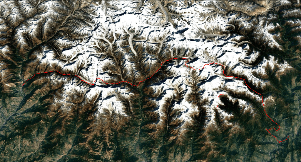
Num-Makalu BC-Sherpani Col-Amphu Labsta-Chukhung-Khumjung-Thame-Tashi Labsta-Beding-Chetchet
My first ever independent trek had been to Khumbu. Back then I had often looked at remote mountain trails on the map. The trails in the Hongu valley and Rolwalling crossing high passes had an almost mythical status in my mind. One day when I grew up I wanted to explore these routes.
Well.. after returning from Greenland I felt like my technical climbing skills were adequate to start thinking about crossing the high ice cols of the Khumbu region. I considered it with hesitation. The Sherpani col has quite a notorious reputation and carrying 200 meters of rope on top of the usual gear really seemed to be pushing the limit of what could reasonably be done on a technical 6000m pass. On top of this Sherpani col is a twin pass, that is to say you need to climb two passes that are close together without a large descent in between (east and west col). This makes Sherpani col significantly more complicated compared to other passes. There is no easy descent once you start the crossing and there is a risk of getting stuck between the two cols if things spin out of hand. The fact however that the pass was very well documented and that the distance between the lodge in Makalu BC and the one in Chukhung is not too to, made it feel achievable.
While doing research I found out that there was another route crossing from Makalu Barun to Khumbu. A rarely visited route through the Isuwa and Apsuwa valley over the Kadum la entering the Hongu valley. I decided to go for this route instead. It seemed more off the beaten track and it would mean that I only needed to bring 50 meters of abseil rope to negotiate the Amphu Labsta la.
The trek got postponed time and again due to COVID, but in summer 2021 my sister and I could finally engage on the trek. We would be the very first tourist to arrive in Kathmandu and turned into somewhat of a Facebook hit in Kathmandu when our tour operator posted photos of our arrival…
August felt like a good time. I had good experience with trekking in the monsoon. The biggest advantage was that we would not be in constant risk of facing snow blocks on the high passes. The more rainy and cloudy weather we would just take for granted. To be honest with our company we would also not be able to go on holiday for so long at any other moment in the year…
Once we got in Nepal it turned out that the routes through the Isuwa valley were not in use anymore. The locals had sold their yaks many years before and the kharkas shown on te map had been abandoned long ago. Having had quite some experience with beating a way through the jungle I knew better than to try and make it through these valleys without a reasonable route.
I thought a while about what to do about this. I decided that the old plan was back on! No more excuses! We would cross Sherpani col, Amphu Labsta and Tashi Labsta. We would cross the three ‘real high passes’ of Khumbu with a team of just 2. We did it right after the COVID pandemic, meaning that we would be the first in 2 years to be on top of any of these passes. It was quite a daring endeavor, but I’m proud and glad that we did it. There was no one I would have felt more happy and confident to do it with then with my sister.
Season
We did the trek in August, but similar treks are usually done early in October or May. These months have clearer skies, but do have a constant risk of your trek getting ruined by an unexpected snow drop. Rain and snowfall in August are way more common, but they melt away in a matter of hours whereas in October it does not melt at all. In a winter with much snowfall the month May can also prove challenging. mid-September is probably the best compromise between few snow, nice temperatures and somewhat clear skies.
Getting there
Num is there start of the trek. There is no real easy way to get there… The fastest approach is to fly to Tumlingtar and then hop on a jeep to Num from there. There is a constant flow of jeeps driving up and down to Num, even during the monsoon so getting on one is easy enough. Num is rather close to Tumlingtar but due to the road it somehow still takes 4 to 5 hours to really get there. Instead of flying to Tumlingtar you can also take a bus there or get a private jeep. The drive with a jeep takes around 14 hours, the bus takes around 4 hours more.
The trek ends in Chetchet. There is a daily bus leaving at 7am for Kathmandu. This bus should arrive in Kathmandu around 4pm.
Videos
Alternatives
There are remarkably few options to get to Khumbu from Makalu Barun. The only other pass indicated on (some) maps is the Kadum la. As mentioned we initially tried to use this pass, but the trails in the Isuwa valley are no longer in use. We did not check on the trails in the Apsuwa valley, so it could be that this route is still a viable alternative.
Crossing from Khumbu to Rolwalling has only one reasonable trekking route which is the one we took over the Tashi Labsta.
Instead of hiking from Chukhung to Thame via Khumjung one could als cross the Cho la and Renjo la. This would combine the Ice cols trek with the classic high passes of Khumbu.
Instead of going all the way to Rollwalling one could of course break off the trek near Namche and go back to Kathmandu via Lukla. You could even shorten the trek further by crossing the Mera la and Zatrwa la to Lukla once accross the Sherpani col.
Day 1
The day before we had come from Kathmandu by private jeep. Normally I would have gone by bus but due to COVID I caved to Nava and agreed to take a private jeep. As usual it had been a long drive. Down here in Tumlingtar it was mostly a battle against the summer heat and moist. Opposed to what I remembered Tumlingtar lay in a broad valley, the town on the hilltop I remembered from my trek with Wico turned out to be Tumlingtar and was an hour further up the road.
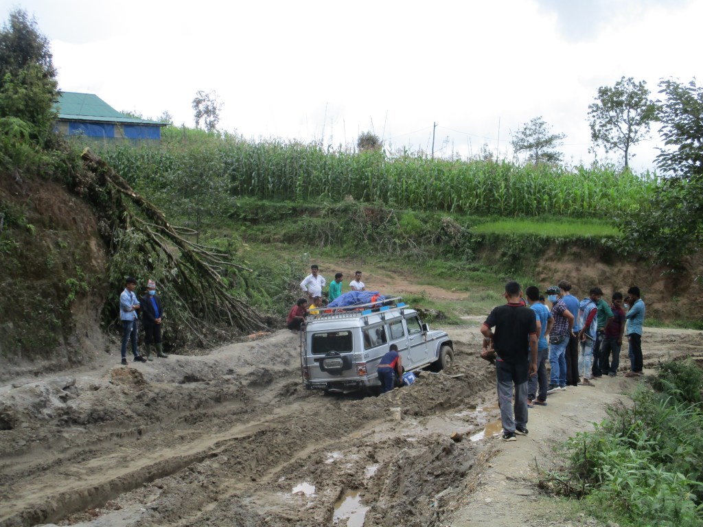
The first order of bussiness in the morning was to arange a jeep to Num. With our guide Ram I went down to the busstop to inquire. They told me that due to the monsoon I could only get a private jeep. I called bull shit but whatever I took it.
I went back to get breakfast and buy some last minute bowls so that we did not need to eat from the pan. With this done we called up the jeep and left for Num. The road up to Khandbari was good. It did not keep the jeep from breaking down however. Once in Khandbari we switched to another jeep with a little less smoke from down the engine and continued. While waiting I looked around and thought I recognized the hotel I stayed with Wico. Funny how these memories get hazy over the years. I thought I remembered it very clearly, but once here it was not easy to really find back the exact same streets.
After Khandbari the road turned bad. Like really bad. It took us several hours to reach Num which was just 15km birds flight.
We drove over the hill ridge that terminated at Num. By times we had nice views and by tims a cloud rolled in covering us and the forests around us in thick mist.
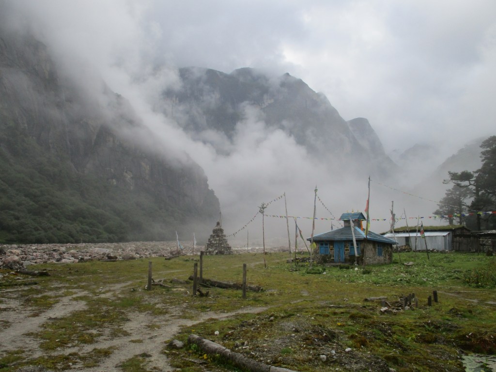
Once down in Num we, by ancient Nepali tradition, got summoned to the police station to give some pointless personal details. After this final bureaucratic hurdle we had lunch and got ready to start our actual trek.
We did not follow the usual Makalu BC trek trail, instead we aimed for Walung in order to go up the Isuwa valley to Narbuchaur. It was a hot walk through damp jungle. We got hot really quick and took every oportunity to get our heads wet.
Road development had advanced enormously since I last visited. When I was here with Wico the Arun valley only had a small jungle trail winding along a few farmhouses climbing up and down to circumnavigate obstacles. Now however there was quite a good road through the valley. The road even had side ways that went all the way to Narbuchaur.
As the evening came I found an explication for the sudden development of the region. An Indian company was busy building a hydro power plant. For this they of course needed the infrastructure. At around 5:30 we stumbled on a house where we wanted to stay overnight. Unfortunately it was already full with road workers. We could get a jeep instead that brought us down the valley and a few hundred meters up the otherside to some other farmhouse where we could stay overnight.
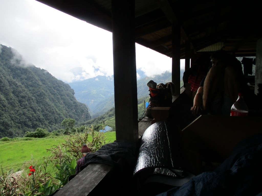
It was a nice place to stay. As usual in the lower valleys of the Makalu Barun region we got to sleep on the balcony. A nice view and a even nicer cool breeze.
Day 2
We woke up for the first full day of trekking. The weather was for monsoon measure pretty good. We were to retrace the route I did with Wico a few years back to get to Narbuchaur from where we would venture into the wild Isuwa Khola.
The route largely followed the jeep track taking a short cut every now and then. It was a firm ascend through the hot sun. I had a hard time recognizing the places I had been. The newly constructed road really had changed the environment.
We got to Narbuchaur faster then we expected having much of the afternoon still wide open. We cheered a bit too early as the household that welcomed visitors was all the way at the top of the village which was easily 100, maybe even 150 meters more up.
As soon as we arrived it started to become clear that the route over the Tak Lung la to Dhupu kharka in the Isuwa valley might form a problem. Our guide Ram found it hard to comunicate with the local town folk, but the message seemed quite consistent. They had sold their yaks many years ago and the trail into the Isuwa valley had not been used for a long time.The older man with whom we stayed told us he had been to Dhupu kharka when he was a young man, but that the kharkas had fallen into disuse.
My sister and I had experience with beating through untrodden jungle and knew that this was generally speaking hard or down right demoralizing. I decided to accept reality and change plans. We would cross the Sherpani col instead. Our guide Ram, who was wiser then us, would join us to Sherpani BC and help us carry our gear till there.
Sherpani col has quite the reputation so from this point on I constantly worried about the pass. During the COVID pandamic no one would have crossed this pass so we might face unforeseen and tough circumstances.
The rest of the day was spent playing volleyball with the locals. They were quite smash oriented and neglected their defense…
Day 3
It would be a long day. Since we changed plans from Kadum la to Sherpani col we were off route and I had my mind set on getting at least on the right track. Funny enough we had to take the exact same route as I had taken with Wico a few years back. As a matter of fact I would need to retract that route all the way to Makalu BC. A bit of a frustrating perspective. Especially as there would be a chance that we would need to give up on the Sherpani col, which would even mean going back by the exact same route.
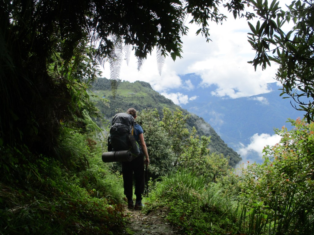
The first part of the day went through dense jungles. We constantly needed to battle the leaches. These bloody beasts were literally everywhere. If you lost balance for a second and your arm would touch some leaves your arms would be under siege immediately.
Near Balakharka the trail got a bit broader. This meant fewer leaches almost immediately. In Balakharka I thought I recognized the house where I had stayed overnight last time. From there I had called home to learn about the scope of the 2015 earthquake we had experienced.
From Balakharka we had to take a different route to Tashigaon then the last time I was there. The monsoon caused denser vegetation so the locals recommended to take the longer but better maintained route looping all the way around the hill ridge.
At this point I thought we were reasonably close to Tashigaon. I was wrong, this other route take more of a detour then I had thought. We had to walk a long distance through dense jungle. At some point I thought we got to Tashigaon, but it turned out to be some other village. They told us Tashigaon was still 2 hours away.
The final 2 hours started out over a broad jungle trail, but after having probably taken a wrong turn it quickly became a small jungle trail. Evening was already falling and we needed to hurry up. The last thing we all wanted was spending the night in the damp jungle with the leaches. As increased the phase we started to disregard the leaches. So when we finally arrived in Tashigaon we were both tired and covered with leaches. We were removing leaches from our skin, shoes and socks for half an hour.
The locals did teach us a good trick. With some sold you could easily kill the leaches, that seemed to be pretty much immune to any other abuse.
The lodge owners were quite skeptical about our plans for Sherpani, but luckily I could buy 200m of rope from them. I had only 100m with me, but I knew I would need more if I wanted to do the Sherpani on top of the Amphu Labsta.
Day 4
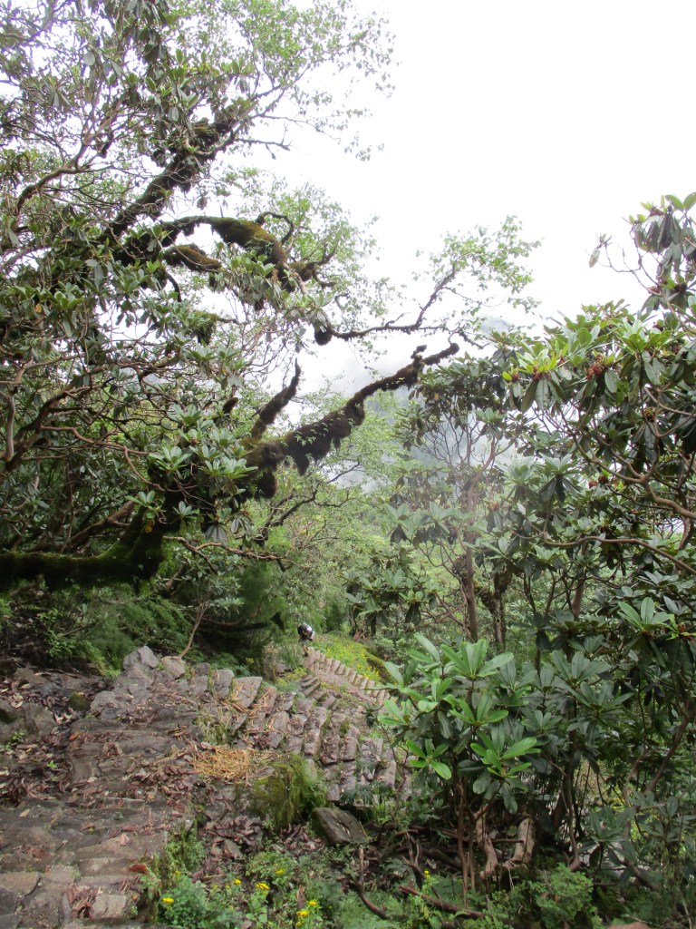
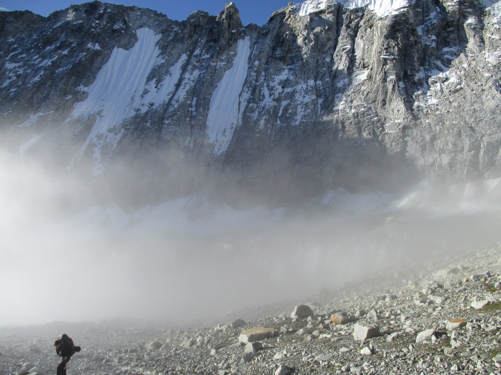
Today we would do the first day of the two day effort to climb Shipton pass. I had came down this way a few years earlier so I knew what was awaiting us. A never ending climb over stairs. Mostly through dense forests.
It was indeed non stop up. We often wondered who on earth had put so much effort in this trail. Building such a 2000 meter high stone stair case must have been a tremendous effort.
As we climbed up the leaches slowly dissapeared. Luckily for us they would likely stay away as we would not be descending to below 3500 for a long time to come.
It was a very cloudy day so we mostly enjoyed the forests directly around us. The lodge owner of Tashigaon was hiking up with us so that he could open his tea house further up. Once we reached his teahouse at around 2pm the weather had gone worse and we just lay in our bed till dinner. A proud tradition that we would honor a lot in the rest of this trek.
In the evening a Nepales traveler showed some photos of Shipton pass. He told us that we could see that tomorrow if the weather would be clear. We started to laugh when he said that. In the dense mist that had come up at around noon it was hard to believe that the weather would clear in the monsoon.
Day 5
The impossible had happened. When we woke up the weather had completely cleared. We could see all across the hills towards the south. It was very encouraging that this kind of weather was also possible. We quickly ate our breakfast and hid the trail. We wanted to be on the pass quickly to see the view and clear weather in the monsson is rarely long lived.
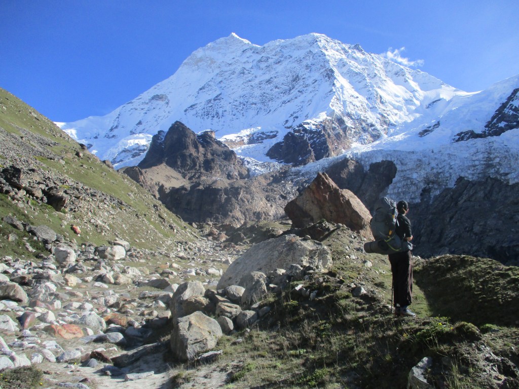
It was about 700 more meters up. Especially considering our heavy backpacks. Especially the 200m of rope really added to the weight we needed to carry. Rose was already jokingly calling it the ‘extra wheel’ because of how it was hanging on my backpack. As usual my sister outran us by a long shot and was on the ridge first. I could see our guide being impressed by her speed.
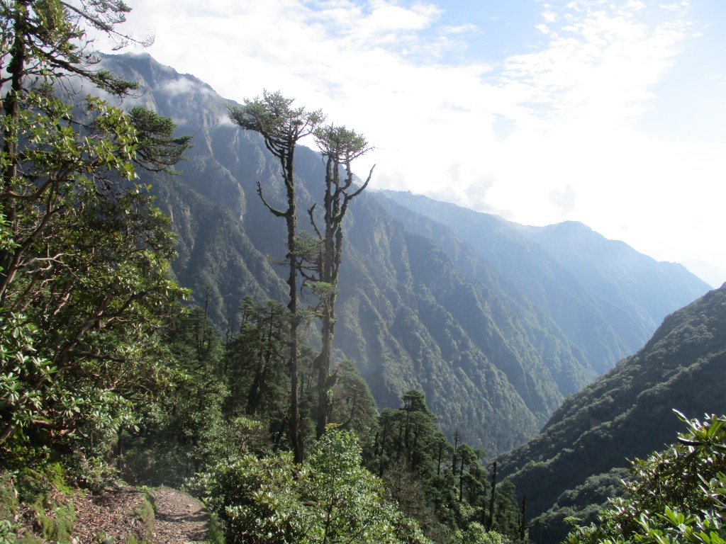
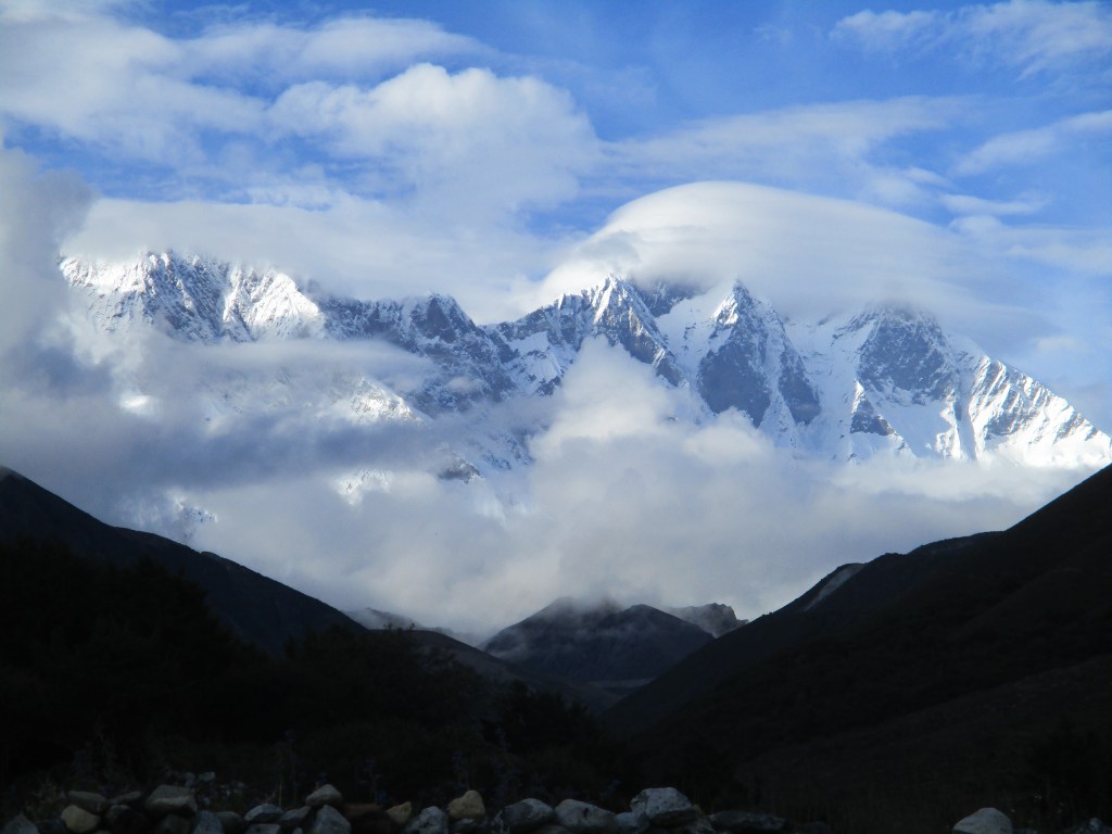
Once we caught up with Roos on the ridge we could enjoy great views over the Isuwa valley. Looking into that vally I was glad that I had not tried the route through there. Especially the start of the valley was covered with dense forest and steep cliffs. When we looked to the north we could see mount Makalu and a few impressive 6000m peaks that bear no name. The Chamlang at the end of the isuwa valley was partly hiding in the upcoming clouds.
The trail went on over the ridge to climb across two minor passes. On the first pass called Tutu la we cooked some quick lunch. After lunch we descended about 300 meters to the tea house. Our host had not yet arrived so we needed to wait a few moments. The Barun valley is rather remote and only few locals utilize it so now with COVID people needed to hike all the way up here from Tashigaon to open them up.
The good weather had made way for thick mist, so when our host did arrived we just went for a nap and thought back about our view from Shipton.
Day 6
We woke with sunny weather. The lodge owner seemed to note that it was quite exceptional for the time of year and expressed that he felt that the weather might be quite stable for the coming days. I could only hope he was right.
North of us we could see the other side of the valley. I looked in detail as I had walked on the other side many years ago. Back then the snow had been hip deep, and I had gotten completely lost resulting in a wild off track ascend. The circumstances now could not be more different. We leisurely descended in the sunny weather.
Once down at the river we followed the river bank up valley. The valley was very narrow. Maybe just 40 tot 50 meters broad. This made the banks rather unstable and we constantly needed to cross landslides and other collapsed sections.
We had lunch in Nehe Kharka. With 1000 nrs it was the most expensive, though still welcome, Dal Bhat I have ever had. During the lunch the clouds rolled in again, something we were getting used to by now. Our hostess told us a similar story as the people in Narbuchaur. She indeed knew there had been a route from Nehe Kharka to the Isuwa valley. But this route had been out of use for a long time and was likely completely overgrown by now.
After lunch we hiked slowly up for another 2 hours to reach Yangle Kharka. Yangle Kharka lay at the point where the valley suddenly broadened. I remembered Yangle Kharka from the last time I had been there. The weather was just as shitty as last time, but I was still impressed by the large rock formations west of us. The rock seemed to rise up almost vertical, with waterfalls tumbling down.
Day 7
A short day would bring us to Langmale Kharka. It would be possible to hid base camp the same day, but we had some acclimatization to take care off first. This time we were not granted a clear morning, so it was a bit of depressing hiking.
The trail took us along some places that normally would be able to host trekkers. But with the Covid pandemic still raging the valley was quiet now.
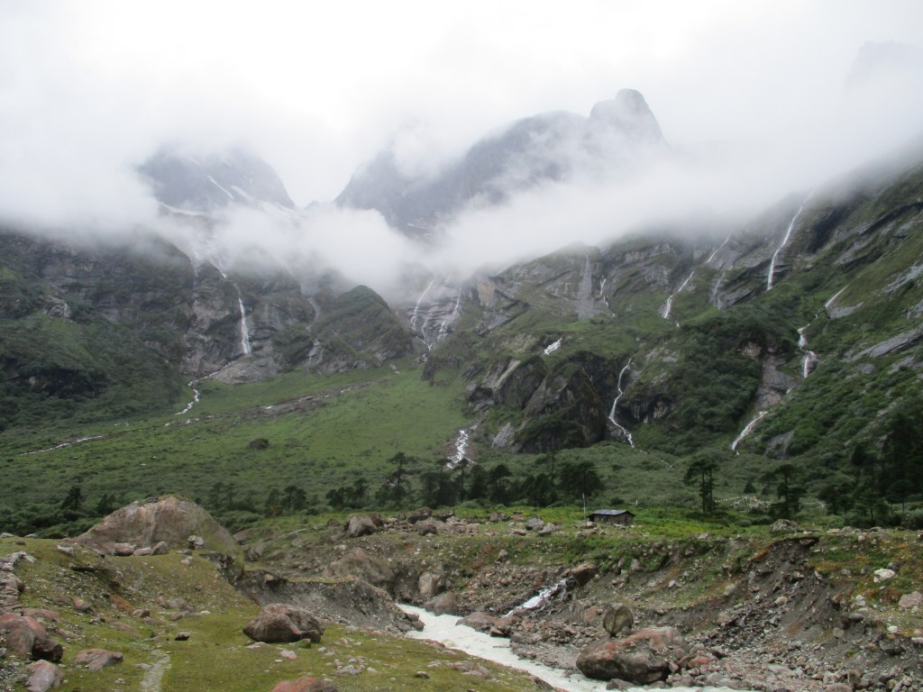
The last stretch to Langmale Kharka were relatively steep up. We needed to climb overgrown boulders that clearly indicated that the Barun glacier was not far away anymore.
Roos made immediate friends with the dog in Langmale Kharka, with whom we shared the curd we had bought in Yangle Kharka. Rose even let him stay in our room for the night.
Day 8
Yesterday had been a long afternoon hanging around in the clouds. Even though an extra additional acclimatization day before heading off to base camp or at base camp itself might have been advisable I decided to just head for the pass and just stay one night at base camp.
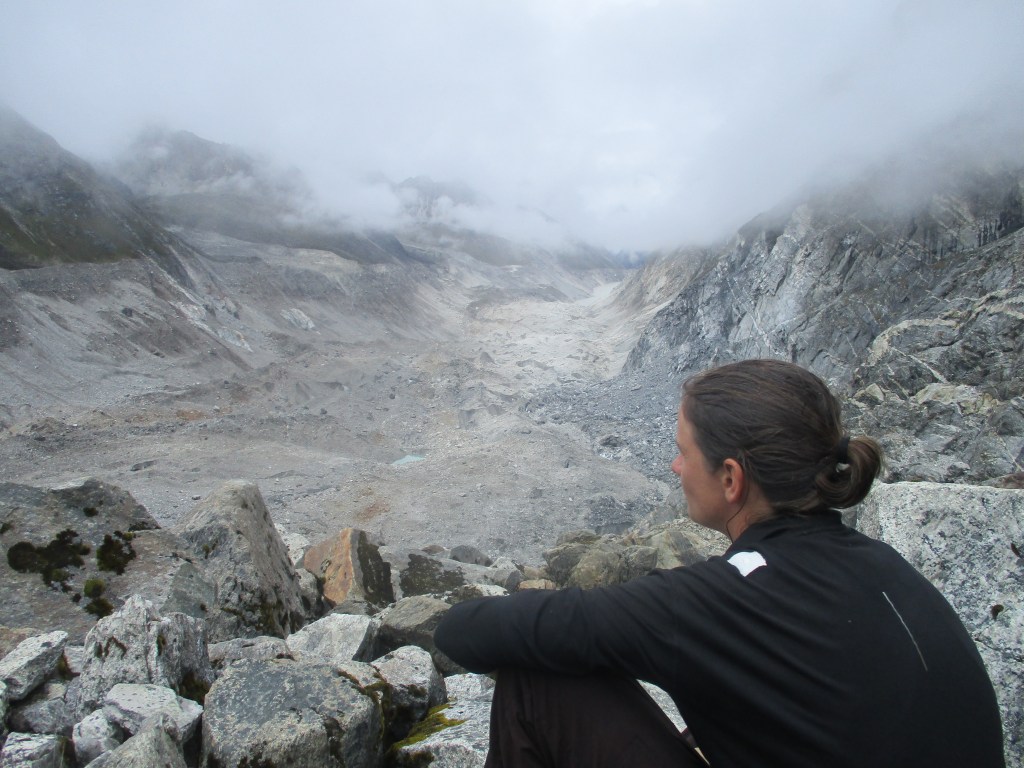
The day started off a bit cloudy, but the sun broke through a lot in the afternoon. We hiked through the meadow to the start of the Barun Glacier from where we hiked along the moraines to Makalu base camp. I recognized the spot in which we had witnessed the 2015 earthquake. In retrospect the flat plane was one of the best possible places I could have been at the time.
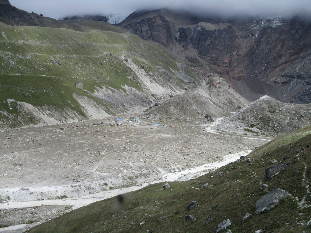
We reached Makalu base camp in the sun. I was great to sit at the front door in the sun while unpacking the brithday present of my girlfriend. She had prepared a mini Ipod with birthday wishes from all my family. To Rose and my delight there were also some songs on it. Then we at least had something to do during the long afternoons. When the playlist looped back to the start after 4 songs we realized we might have cheered to early though… Well I guess 4 is better then none at all.
After an hour or 2 we saw the lodge owner arriving. Good, we were starting to get worried. Once inside we studied the stickers in the dining room to find proof of people doing this route during the monsoon. We again found a ‘GHT team monsoon’ sticker, so apparently it was not unheard off.
Before going off to bed we did some final birthday celebration dancing. The feeling for rhythm of our guid was so off, that it was not easy to dance, but it was nice anyway. It felt like our last chance to enjoy easy life. The days ahead would be challenging. 40 kilometers of pure rock and ice, with only a faint route that had not been trodden for almost 2 years.
Day 9
we woke with perfect weather. Makalu had been hidden yesterday, but now it towered over the base camp. It was hard to look away from the iconic golden tip of the massive mountain. As per usual with good weather, we hurried up and hid the trail directly after breakfast.
Our objective was swiss base camp, just 2 hours ahead.
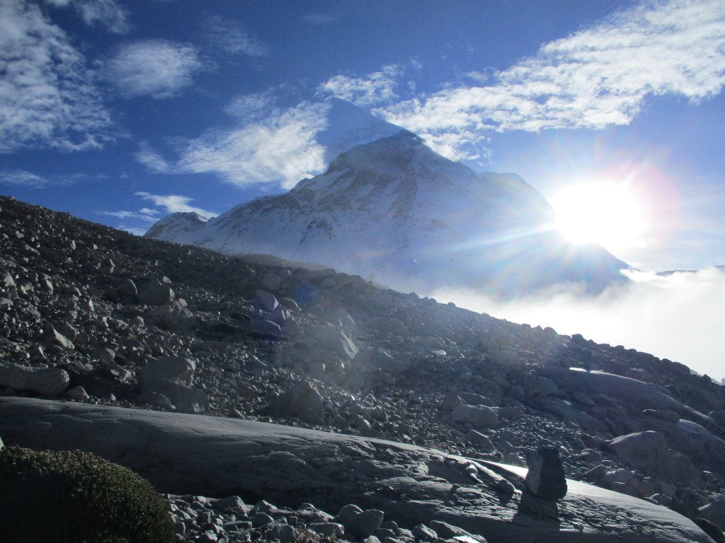
We hiked steadily up till leaving the Barun glacier about hundred meters below us in a steeply carved gully. Once we leveled we could see deeper into the valley. At the end we could see the Lhotse and a little bit of everest. It was a very impressive sight and I was simply very grateful for the weather.
The location of Swiss camp was not really clear. We had likely already passed it. It was time to start looking for a camp spot, but the patches of grass had dissapeared by now and there was remarkably few water to be found. After a bit of searching we however found a reasonable spot with water just 50 to 100 meters away.
Once again we had to kill a long afternoon. The sun made the tent too hot, but outside we would burn alive. Our guide Ram found it very funny. He had never before felt so warm at such a high altitude.
Day 10
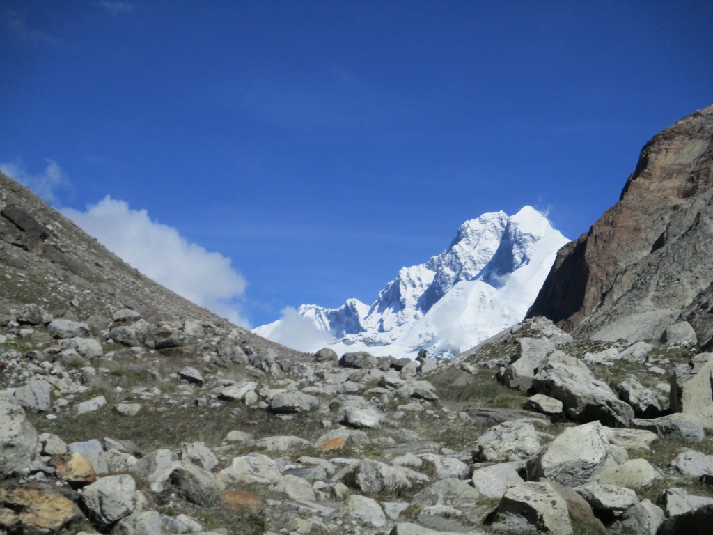
One last short day before we would make our attempt for Sherpani. The last hints of grass and vegetation were now behind us. It was just plane rock and boulder as far ast the eye could see. After scrambling over the rock for half an hour we reached the first side valley. There were clear signs of large scale camping here. Apparently we had opted out to early yesterday…
The route from here was not so clear. It was tempting to start following this side valley. But I knew this to be wrong. The side valley would take us to the old pass way less used pass. We would need to go to the next side valley and hike up there. My first instinct was to descend down to the glacier, but the glacier had carved very steep sides so it did not look too promising. After looking around more carefully we saw that there were some stone mans leading us further up via the valley side. We followed these markings and after an hour and a half we reached the second side valley.
The route seemed to have collapsed here. The side valley floor was about 40 meters below us, but this last 40 meter stretch went over a steep wall filled with loose gravel and rocks. Not something you want to see. Loose rock on a 50 degree or more slope is quite dangerous. We hiked a few meters to find a good way down. I was not very motivated to hike further up as the altitude was weighing heavy on my breathing. So as soon as I had the idea that the way down was doable I started my descend. Ram and Roos waited to see how it went. The initial meters were easy, but as I continued I wished I had spent a bit more time looking for a route. However when I was down and looked from where we came from, I could not really make out an easier way down.
Once down we pitched our tent near a small spot where we could reach the water down the boulders. Ram was looking worried from where we had come from. “How will I get back up?” he asked. It was indeed not something to look foreward to. I could not pity him however, retracing our steps was a minor inconvenience compared to the route over Sherpani col that Rose and I would need to follow coming days.
After lunch Rose and I gathered our strength to explore the route to the East col. We wanted to spot the pass so that we could make a good start tomorrow instead of getting lost in the dark. It was quite a long way to the start of the small glacier from where we could spot East col. At the start of the glacier there was a very large camp spot. (Once again we had opted out too early) Using the photo of the pass I had printed and taken with me, we could easily spot the pass. The pass however looked incredibly steep. From the glacier it looked like 100 meter of rock at a slope of more then 70 degrees. I returned back to camp rather concerned about this, I had expected east col to be the easier one of the two, but this col already looked pretty intimidating. Rose was more hopeful, she blamed the optics. Surely if it were really that steep, people would not trek it right? “We are just going to top this thing “she said.
Day 11
The big day was there. I had thought about it a lot since we had switched plans all the way back in Narbuchaur. Each time I had thought about the chance we would need to turn back due to unforeseen conditions. There had been no reports about this route for almost 2 years. Literally anything could have happened.
We woke 3am in the night. It was a good thing that we had already explored the route ahead, otherwise it would have been easy to get lost on the rocks. Slowly but steadily we made our way to the glacier. Our bags were heavy with the ropes. At sunrise we got to the large camp space at the foot of the glacier. Mount Makalu was rising up behind us. We could notice that we were high, as Makalu did not seem that much higher up anymore.
We took a small break to discuss where we would climb up to the glacier. After a bit of consideration we decided to take the route via the right. A good choice it turned out. Once on the glacier we put on our crampons and started marching towards east col.
I kept my eye on East col, constantly hoping the pass would be less steep once we change our angle. It did a little, but it still looked darn steep. Once we were getting close I had difficulties to keep up with Rose. The air was very thin and my bag pretty heavy. Rose who always acclimatizes as a god took over the rope from me for the last stretch.
I reached the foot of the pass completely out of breath. We took a Snickers and studied the rock. When having a close look I could see an iron rod hanging. Great we found the route! It was a very steep climb over dangerous loose rock. Our heavy backs and the heavy breathing made the climb very difficult. It was hard to muster enough strength to pass the difficult parts quikcly.
Half way the climb we made the poor decision to hang on an old fixed rope instead of the iron rod. The rope broke and I fell straight down. I rolled a few times but luckily Rose had better footing and was able to break the fall for both of us.
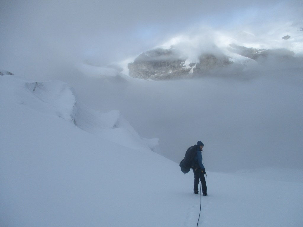
Once on top we could see the lower Barun glacier west of us. It was a very steep drop of about 60 meters down. Steeper then I had hoped. The clouds were moving in and west col on the other side of the glacier slowly but steadily vanished from our sight. The worsening whether, our fall, the thin air, the immense glacier and the extremely steep drop made us very seriously consider to just turn back.
We rested for a couple of minutes while I was preparing our abseil rope. We were in real doubt whether we would try to descend or not. Sherpani is very tricky as the lower Barun glacier is in between east and west col. Neither of these cols can be easily crossed. Getting stuck is a real danger. In the end we decided not to give up. The first part of the descend we abseiled or rope through very deep snow. In the last stretch over the rock we could use the already existing iron rod.
Once on the glacier we got a very nasty surprise. It was only 10am, but the snow was completely ruined. The snow was so soft that you fell hip deep into it. It was so bad that we ended up just crawling. West col was only 2 kilometers away, but after just 10 minutes of hardship we realized that there was no way we would reach west col today. Sloughing through deep snow is exhausting, let alone on 6000m.
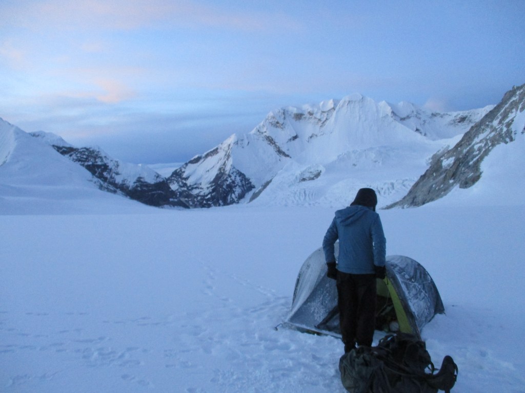
We decided to setup camp and continue tomorrow early in the morning when hopefully the cold night would have frozen the top layer of the glacier. Rose and I were experienced snow campers by now and had our camp setup in no time. laying on the snow felt oddly familiar by now. The cold crept up from the glacier while the heat of the sun was toasting us from above. We knew we would get a cold night as we saved a lot of weight by cutting down on the quality of our camping gear. I was a bit nervous to get altitude sickness. We had descended relatively quick, and imagine that we would get sick here, between two steep passes on 6000m….
During the evening it began to snow. Really not something we were waiting for… I could not sleep as I wanted to keep an eye on the weather. I wanted to be able to react if we would get an all out snow storm. Luckily however this did not happen. Early in the night the weather started to clear up quickly.
Day 12
The night was indeed very cold. But it did not bother me. The skies remained clear and the colder it was the better the ice would be tomorrow. When we woke at around 4am the weather was simply stunning. There was no cloud in sight and we could see the countless peaks of Khumbu waiting for us on the other side of west col. However to get to Khumbu we would still need to make the notorious abseil from west col.
We swiftly packed up our tent. We had kept our shoes in water tight backs between our sleeping backs as we knew our shoes would have frozen over otherwise. The ice held our weight well. We made our way to west col with amazing speed. Unbelievable how fast we were able to go compared to yesterday. Conditions are indeed everything.
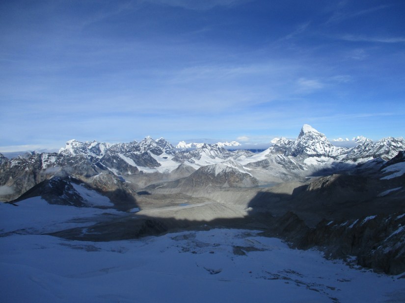
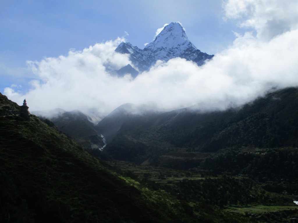
West col lies at almost the same height as the lower Barun glacier and it was easy to get to the top. Once on top we could look down to the Hongu basin 200 meters below us. It was a very long and steep descend. But actually not as steep as I had thought. The descend from east col had looked way nastier in my opinion. In good spirits I started to fix our main 200m rope. I took my time for it in order to enjoy the amazing view to the west. I recognized many peaks that I had seen during my Everest base camp trek many years ago. Most notably was the Amadablam.
When the rope was fixed I started the descend. The first 100 meters were easy, but then, of course, the rope got all tied up. I think I spent over half an hour to descend the last 100 meters. Each time trying to untie the endlessly long rope. Twice I was so fed up that I cut the rope and tied it together again with a carabiner. The weather was good, clear skies and warm weather so it was fine. Rose was cheerfully watching my efforts and making videos of the views.
When I made it to the last stretch of rock the main rope was almost finished. Our 200m rope was not long enough to abseil all the way down. I called Rose so that she could abseil as well. I planned to fix a second rope and to use that to descend the final stretch.
While Rose was descending I could really see how big of a drop it really was. Rose descended quickly, but still it took quite some time for her to get down. Once she was down we slowly climbed down all the way to the Hongu glacier.
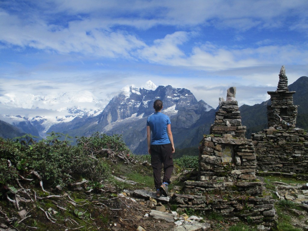
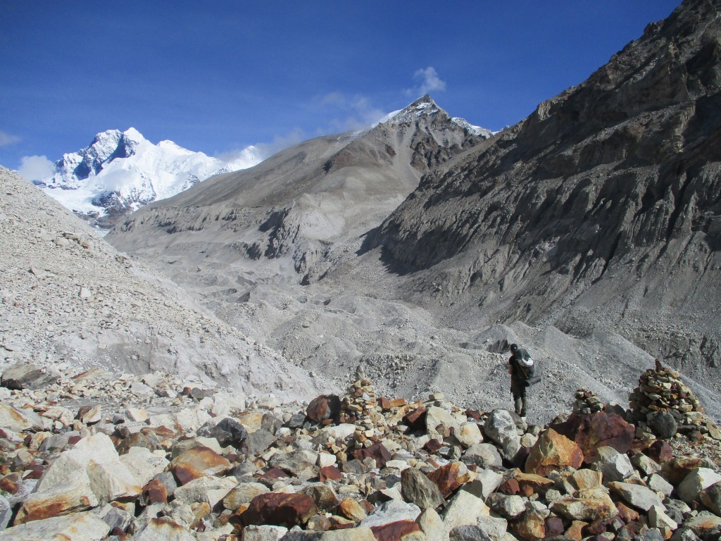
Once down we were happy to find the glacier in good condition, it was still well frozen and could hold us. We descended the glacier by looping all the way along it southern side. This meant that we needed to keep altitude and even climb up a bit in some points. Even with lighter backpacks I could still notice that we were at 6000m. However the way back to a more reasonable 5500m lay now wide open.
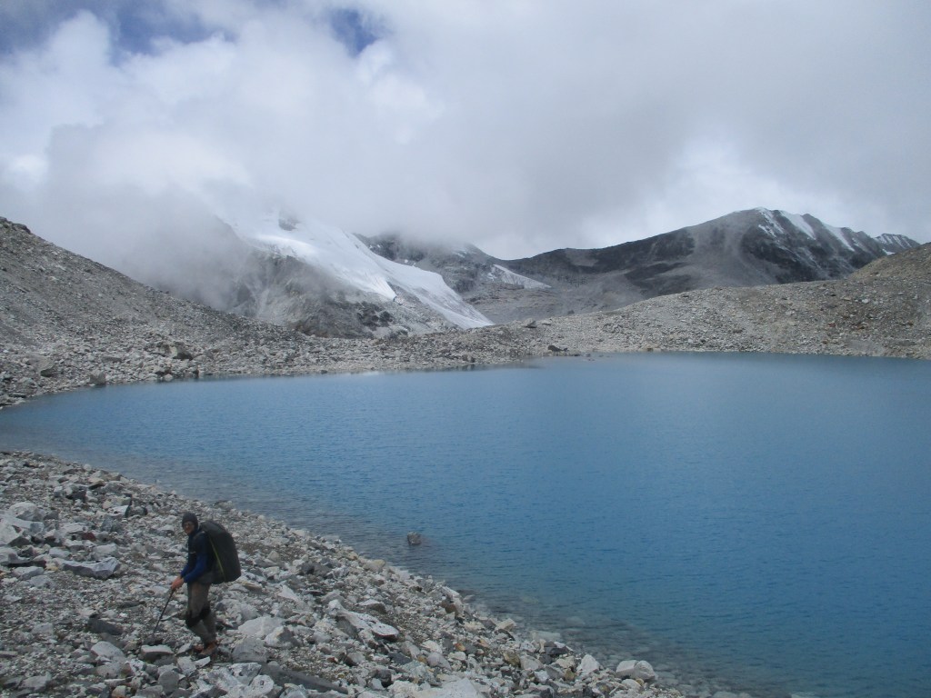
As always we made it off the glacier, hungry, thirsty, hot and with a full bladder. Large piles of stone indicated that more people had been glad to be off the ice. We were both really proud of our achievement. Few people cross Sherpani col unguided and even fewer would do it in these conditions. The Hongu valley itself added to the euphoria, it was a remote, wild and barren rounded valley. It was completely deserted and we had the famous peaks of Amadablam and Baruntse all for ourselves.
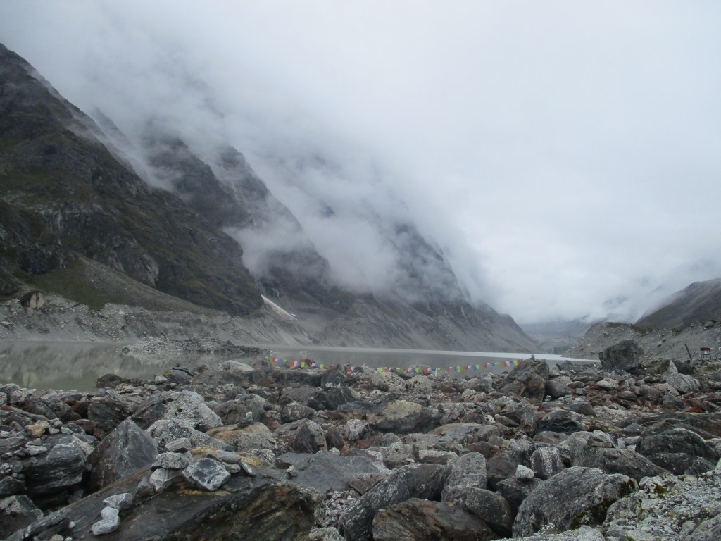
We walked down for about another hour till we reached a large lake. We setup camp here, so that we still could decide whether we would continue our trek to Khumbu across the Amphu Labsta or across the easier Mera la. The weather had clouded up, but the sun still burnt our tent. We had to choose between being boiled in our tent or getting sunburn outside…
Day 13
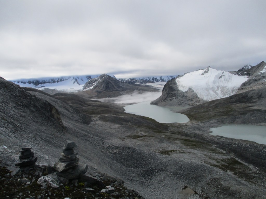
We would hike across the uninhabited Hongu basin to Amphu Labsta base camp. It seemed easy enough, we could already more or less see the place we would like to camp and the valley floor seemed rather leveled. We did however need to cross the moraine filled glacier and this was a bit nastier (as per usual when it comes to traversing the lower sections of glaciers) then we thought. Once across the glacier we climbed 150 meters steep up where we met up with a few stone man again. It was good to see them as we had before that point not really an indication that we were even remotely taking a good route.
From this point the going was easy, there was no trail but the terrain was remarkably flat with good boulders. We hiked to a nice like on the top of the divide and then back down again towards Ampu Labsta base camp. As we were getting closer the weather worsened. We were a bit uncertain what exactly to look for, but when we saw an abandoned house we felt like this was probably the place people would normally camp.
We first sought shelter in the house, but the roof was more or less fully open so that did not help much. We pitched our tent in the rain and hopped the meteo would improve a bit tomorrow. The pass was sometimes visible through the clouds, it looked, compared to Sherpani col, pretty doable. I did for good measure steal 100m of rope from the abandoned house. Bad for my Karma, but as I had only about 100m of rope left, if the iron rod on the other side of the pass would be gone I might find myself with insufficient rope.
Day 14
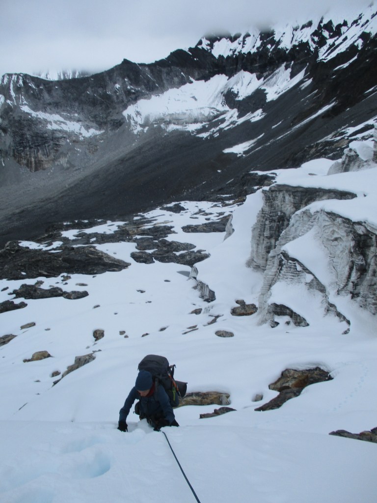
Well the weather wasn’t great, but at least it had stopped raining. We quickly climbed the steep trail across the stone slopes forming the first phase of the climb. If we could climb like this the whole way we would have been on the pass in just 2 hours. Unfortunately however the snow around the pass was complete shit. I don’t think it froze here during the night and the weather was wet. Even in early morning we fell completely through the snow everywhere we set our feet. In the first 50 meters it was ok as there was only a thin layer of snow, but soon we found ourselves ploughing through hip deep snow. At the times we looked back after battling the snow for a while, it felt like we barely made any progress at all.
I had expected that we needed to climb some of the steps in the glacier. That was at least what many of the movies on Youtube had lead me to believe. However once here it appeared that the route climbed next to the glacier. We could make out the route as there was an iron rod that was sometimes visible. Unfortunately the rod was not usable as it lay under over a meter of snow and could not easily be dug out. During the pandemic years the rod had probably not been used and that way had sunk further and further into the snow. Some climbing Sherpas probably will need to fix a new one when trekking parties come again.
Without the iron rod the climbing was difficult, even a little dangarous. We had to climb 50 degree slopes with hip deep snow. We went one by one, taking turns to anchor one another.
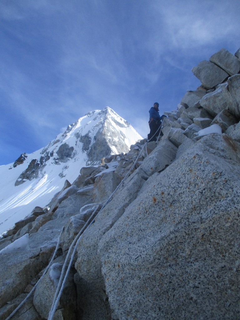
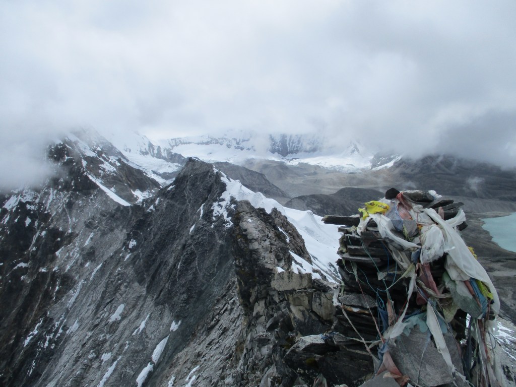
After two hours of snow ploughing we had had it. Especially my sister. But even though it by times felt like we were standing still the pass undeniably got closer. The problem however was that the ramp to the pass was rather broad, there is a 300 meter section on the ridge that the pass could potentially be. 300m does not sound like a lot, but with the snow conditions we were not happy to walk around that area in the search for prayer flags.
However with some luck (and a bit of skill) we managed to land right on the pass. We were both quite relieved to see the prayer flags. The pass itself was very beautiful. It is a long sharp ridge separating the wild Hongu and Chunkhung valleys. The clouds were haning low so there was no view of Everest but the pass itself was actually spectacular enough to make up for this. We spent quite some time on the pass making videos and enjoying the views. This place really gave a feeling of climbing in the highest mountains in the world.
The northern side of the pass was (luckily) almost completely free of any snow. There was an iron rod and the way down was actually pretty clear. We did one fixed rope abseil but for the rest we could just climb down using the iron rod. I ruined my karma stealing that rope for nothing ;p.
Once down from the pass the weather worsened and it started to actually rain. We were happy to made it across the pass. We now had all real obstacles behind us, so we could manage a bit of rain. We however knew that Chukhung was still quite a long way. With the thought of a warm bed an good dal bhat we started hiking again. We needed to round mount Ama Dablam so the kilometers ticked away slowly. There was not much of a view as the clouds came further and further down.
Once in Chukhung we were completely wet and cold. We were happy to see smoke from some of the chimneys as in my mind there had been a real possibility that Chunkhung would have been completely deserted.
Most lodges were indeed closed but one had still people in it. We were the first guests since the start of the pandamic and were greeted with some suprise. The suprise made way for some admiration when they learnt we had come from Sherpani col and Amphu Labsta. ‘No guide no porter?’ they often asked. ‘you are very strong…’. We dried our stuff at their yak poop powered heater, ate all dal bhat we could and enjoyed a warm bed. We were pretty content with our achievement. Only Tashi Labsta was left and that pass had a way softer reputation then the ones we already crossed. It was also a good feeling to be back in Khumbu, the very first region I had indepedently trekked. I looked foreward reliving the good memories I had with my trek with Eefke, then my sisters girlfriend and now her wife.
Day 15
The weather had somehow manage to worsen further. The clouds had come further down and formed a mist in the valley and there were few clues that any high mountains would be nearby. I had told Roos that Khumbu held some of the best mountain scenery in the world, but we could just as well just be in the Scotish highlands. We hiked down to Dingboche. Dingboche is a large lodge town, but it was completely deserted now. Justifyiny my fear that Chunkhung could just as well have been completely deserted. We descended further to Periche that still had one lodge open. We took some lunch here and discussed how we would trek to Thame, the last village before we needed to cross Tashi Labsta. We had two options. The high route over the Cho la and Renjo la offering some great mountain views or the low route via Namche Bazaar offering some more cultivated aspects to our trek. We chose to trek via Namche Bazaar as we deemed to already have enough high passes in our trek. This route would probably give some more veriaty. Besides the weather was poor and so the views would probably dissapoint anyway.
Having made this descision we headed south towards Pangboche at the foot of mount Ama Dablam, one of the most beautiful mountains in the world. In the evening the weahter cleared and we could see the surounding mountains including Everest behind the high Nuptse wall.
In Pangboche we finaly had 4G again. In the upper reaches of Khumbe the wifi and 4G had been down due to weather conditions. We got some bad news from the home front. Eefke had gotten a skin cancer diagnosis. Roos was very sad that she was not back home to support her. We rescheduled our flight to go back home a few days earlier. This meant that we forfeited our extra days and now had to make a few long days to get to Kathmandu on time. The schedule was more tight but not unreasonable. We thought about shaving off even more days and going down to Lukla instead. But with the current weather this would actually be a risky move. Hiking down all the way to Phaplu and then taking a jeep was also an option, but that would only save us 2 days and I already had done that route before.
Day 16
The day began good. We had quite a lot of gaps in the clouds and the sun could break through the clouds. We hiked down to Tengboche and then to Khumjung. The way from Pangboche and Tengboche was extremally enjoyable with lots of small Buddhist details. ‘Oh common, you cannot make this up’ my sister remarked seeing the many colorfull flags, stupas maniwalls with in the backdrop the vast white mountains.
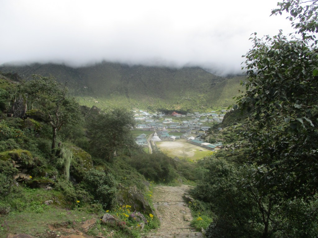
Once in Tengboche hiked 500m down to Punki Tenga to hike up again to Khumjung. We had decided to hike via Khumjung instead of Namche Bazaar to avoid unwanted scruteny over the questionable legality of our trek. (Crossing the Tashi Labsta officially took a permit and licensed guide. We had the permit, but kind of lost our guide as he had turned back before the Sherpani col). Once we started our climb up to Khumjung the clouds had already formed a thick mist giving only a few hundred meters of visibiity. As opposed to my last monsoon trek this time the rainy season really showed itself. We stopped at a small lodge before the main town started. It remained a little weird to be here without a single other tourist. Everything around us pointed to the fact that normally many people would be here.
For the first time ever we treated ourselves on a Yak steak from the menu. I had never ordered it and was pleasently suprised by the burger like thing we got served. We also bought some improvised dryfood for our trek to Tashi Labsta.
Day 17
Well the weather seemed intend to remain shit. It was a little better then in the evening, but that was just the morning kicking in. For some reason the morning and evening hours alway caused a little clear up. But it was clear the clouds would come down quickly again. We hiked through the main village of Khumjung and then through some nice pine forest into the Bhote valley. In the Bhote valley we were greeted with relief. People saw us as a sign that more trekkers would finally return to the region. Lodge owners here had not gotten any government aid so some influx of money would probably be very welcome.
Once in Thame we had lunch in the ‘Marathon runner lodge’, as the names of lodges are almost without exception very very honnest in their advertising, this lodge was owned by a woman who had run many marathons. Including of course the famous Everest Base Camp marathon. She was suprised by our plan to tackle Tashi Labsta, but took a lot of comfort in the fact that we had already crossed Sherpani col and still lived to tell the tale. We bought an extra can of gas and a little extra food for certainty.
After lunch we set out to the Tashi Labsta. Our plan was to just hike up for a few hours so that we could cross it the next day. The Tashi Labsta is very close to Thame. Just about 10km. But it is a staggering 2500m up. The weather was bad. It rained constantly and the visibility was just 200 sometimes 300 meters. We came across a few locals that told us to return as there was no way we would be able to find the pass in these conditions. Roos and I were not too concerned though, we felt the hardest part was already behind us.
Once the trail met up with the river we set up camp. We could have hiked further, but the rain had demotivated me too much. The rain kep falling and we spent the rest of the day in our tent.
Day 18
Ok we gave it up, I just accepted in my mind that the weather would not clear up anymore during our trek. We counted ourselves lucky that we had had such good weather in the Barun valley and while crossing Sherpani col. We packed up our tent and continued hiking up via the trail. After about an hour we came across a few yak houses that also included a small lodge. Damn it… Could that Marathan runner not have told us so? Then we could have just slept in a lodge instead of in a tent in the rain… Well literaly water under the bridge i guess…
After the yak houses the trail got smaller, but still followable. The locals who told us we would get lost had told us that the trail would continue to some lakes and that we would get lost after there. So that gave us some indication on how long we would be able to follow this trail 😉
It took us several hours to reach the lakes. And about half an hour more to reach a small hut used for shelter. Here the trail stopped, but when paying close attention we could still follow a route faintly marked by stone man. After climbing the steep boulder filled slope behind the shelter we arrived at the start of the actual glacier. Here the stone man stopped and we had to use common sense to reach the pass. The poor weather indeed made navigation difficult. We could not see the pass and only see bits of our surroundings by. I had some sense of how the route should go and we slowy continued constanlty watching for clues.
The bit right before the white glacier leading to the pass itself starts is most tricky. Firste we needed to climb a steep slope with loose scree. After that a few dozon meter over semi steep rock. We discussed for a while what the best route would be. There were a few old fixed ropes haning on the right making it tempting to try that way. But the route via the left seemed from what we could see easier. We decided on taking the left route. It was a bit tricky, but it definetelly was the easiest route. We now stood on the white glacier itself. It was now a relatively flat 300 maybe 400m to the pass itself.
Of course however the snow was in poor condition, making it actually a hard slog with hip deep snow.The weather was soo bad that we could only see the pass when we were just 50m from it. We wanted to setup camp on the pass to have a chance of some view in the next morning. By now we were so well aclimitized that spending a night here would not be so tough. Maybe the snow conditions would also be better in the morning.
Day 19
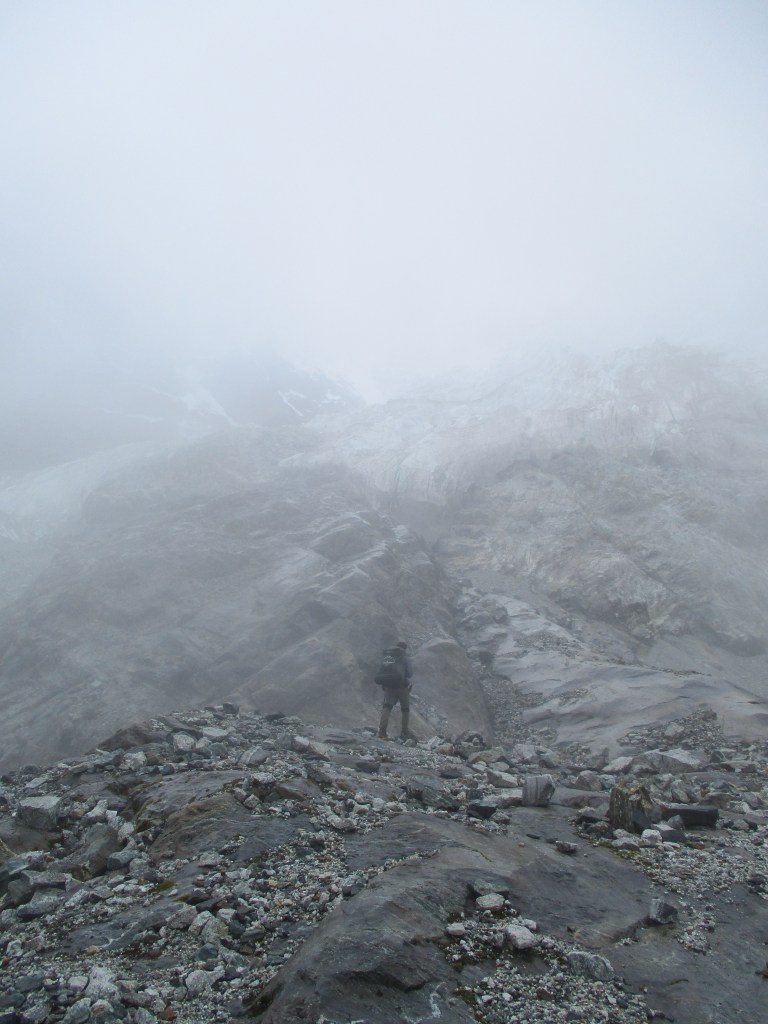
Well the weather was only marginally better. But at least we could get some sense of where we were. The snow conditions were just as bad as they had been in the evening. It was just too warm. Even during the night it did not properly freeze. It was now even worse then having knee deep snow. THe snow now held you for a step or two and then you would fall trhough till your hip. After which you needed to get yourself up again, just to fall through again 2 steps later. Descending went just as slow as our ascend the day before. But oh well, I knew it was not that far. I think we had to do about 600m steep down over the white glacier to meet up with the main great glacier down in the valley. The last bit of the descend went across very steep ice. I think we needed to climb down 50 meters over 60 degrees ice. For the first time I was honnestly glad that we had brought crampons and ice axe.
Once down we were at the side of the great glacier that we would need to follow all the way down to Beding. WHen we looked around we saw clear signs that many groups had used this spot to camp.Most groups crossing this pass would propably do it in the other direction as we were doing it. Comming from this side gave you a much more gradual ascend instead of the murdering 2500m straight up from Thame.
It felt like we made it across and it would be smooth sailing from here on out. It was easy walking next to the glacier and we saw plastic and carying baskets everywhere.Things were looking good. We had some hope to reach Beding that day. That hope however quickly faded when the white glacier turned into a moraine filled glacier. (Our old nemesis). We could see Tso Rolpa in the distance, but to reach there we would need to climb steeply down tot the glacier below and after that hike across endless steep piles of scree and boulders. This was going to take a while… To make matters worse the lake seemed to be surrounded by steep slopes. It was not quite obvious how we would even get past it. We made our new goal to reach the lake, that already seemed way by ambitious enough.
The climb down was pretty steep, but made easy with fixed iron wires. The route was marked with stone man, often you just had to have faith that the route would somehow continue as you could not see far ahead and it felt like you could get stuck on a cliff at any time. Once down on the moriane filled glacier the hiking started out easy, but as we continued further down the piles got higher and higher and the progress was slow. We kept on the south side of the glacier. In hind side we should have stayed a bit more in the middle at some points, but it’s hard to get a really efficient route here.
As the day progrssed the weather got more misty and we could not see much ahead anymore. However by this time a small route next to the glacier was visible and we started to follow that. We came across an ovious camping spot where we then pitched our tent. We could not see the lake, but my GPS indicated that we were close. Hopefully tomorrow we would reach Beding as our food had run out by now.
Day 21
When morning broke it turned out that we had camped right at the start of the lake. So we had indeed made our goal yesterday! There was a faint route marked with stone man on the south side of the lake that we followed. At some point we lost the actual route, there were a few stone man that had lead us astray. There were still a few stone man to be found but it was not very convincing. We thought for a moment. Our GPS indicated that the route was actually 150m above us. Traversing the 60 degree slope along the lake here did not seem as a great idea so we climbed further up. Luckily we indeed met up with an obvious route again. This time the route did not dissapear, in fact after a while it turned into a trail. From above we had some nice views over Tso Rolpa. I could indeed imagine that locals were woried that this lake would one day break and couse death and havock all across the Rolwalling valley. It seemed like a matter of time… A comparable situation as the people in Khumbu face with Imja tso.
At the end of the lake there was a small hydro power. From here on the trail got broad and well maintained. Looking down we could see the first waterfalls down in the valley. The first of many to come. I still remeber Rolwalling for it’s countless waterfalls. Just so much water rushing down from the mountains.
The first place with people we came across was Na. The oldest settlement in Nepal, whatever that may mean. We took some lunch there but pressed on to Beding as we had a tight schedule to meet now.
Na and Beding are about 2 hours appart but are totally differnt. Na lies between broad meadows and has many yak roaming the area. Beding however lies in a narrow valley in the forest. There were quite a few lodges, we simply took the first one we encountered that appeared to have a ward.
Day 22
We wanted to make it all the way down to Chetchet at the trailhead and take the bus back to Kathmandu the next day. This meant we had a long day ahead so we started early. The trail however should now be easy and well maintained.
The trail first took us through nice pine forests that as we descended slowly turned into jungle. Even in thick mist the Rollwaling valley was very ejoyable to hike down. The dense jungle and the countless waterfalls made a lasting impression.
We did not came across any major settlements till Simigaon. The Rollwaling valley is rather thinly popualated. Simigaon was quite a pictureseque village, with farmfields, prayerflags and playing children. If we had the time we might have spent the night here, but we did not want to miss the bus tomorrow and therefore descended further down to the less inspiring Chetchet. Chetchet is just a dozon houses next to the road. The settlement itself was not much, but the roaring river in the deep valley was quite impressive. I don’t think I have ever experienced water in such a rush to leave the mountains. High waterfalls and big rapids were everywhere.
In Chetchet there was one small hotel where we could stay, though for some reason that seemed to be a difficult matter for whatever reason. Simple things like getting food and shelter were for some reason hard to comunicate… We did understand that the bus to Kathmandu would be here daily around 7am so we just skipped dinner and took comfort in the fact that we would be out of here early the next day.
The way back to Kathmandu was despite of the heavy monsoon without complications. In all rest we could look back on an amazing crossing of the three high ice cols of Nepal. I could not believe how lucky we had been to have this experience all for ourselves. The summer of 2021 right after the pandamic (may be cheering too early here) was probably the only time since 1980 that Khumbu was free of tourists. The price had been expensive and ever changing flights, pcr tests, quarentines, stupid paperwork and all the other weird wonders of post-COVID travel. It was worth it, no question.
