

October/November 2021
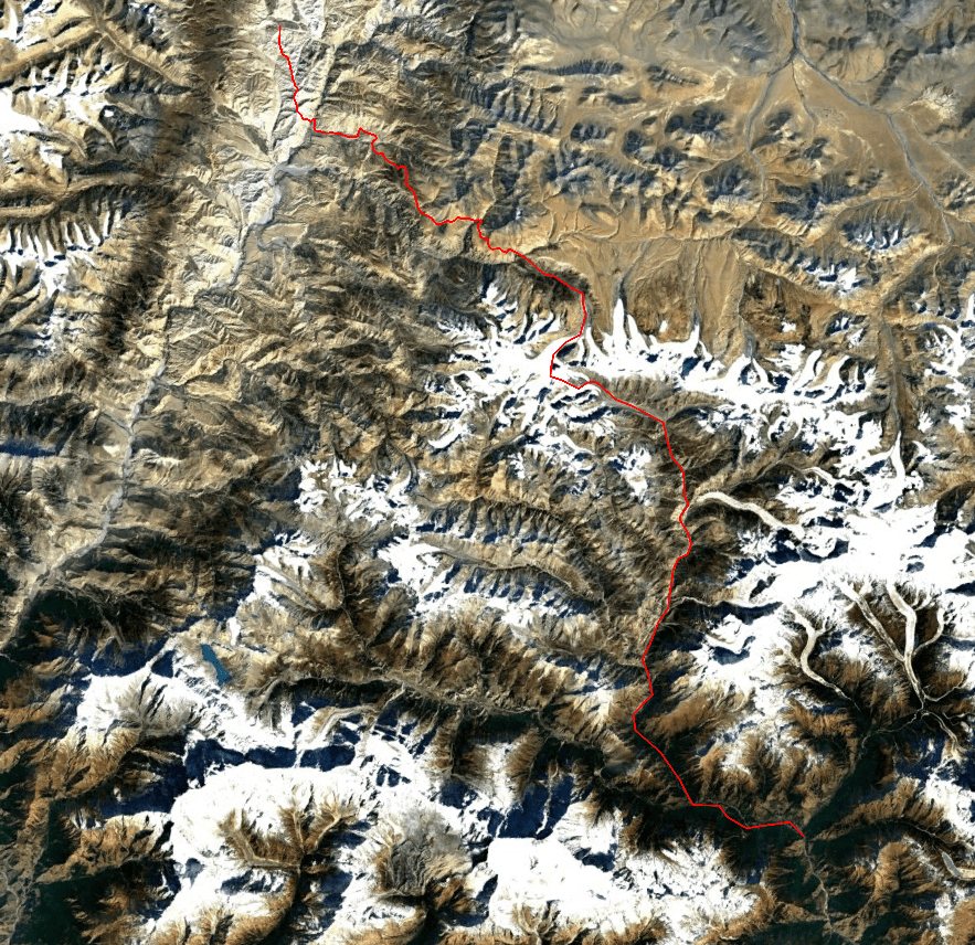
Lo Manthang – Yara – Damodar Khunda – Saribung – Phu – Koto
The Saribung trek had been on my radar for years. Each time however it lost out to some other destination or I had difficulties finding a suitable team. When I finally had a date in mind, I still had to keep postponing this trek for almost 2 years, due to COVID issues. Each time I postponed it the person I would do it with changed. First I would do it with my mother (good call that that did not come to be), then with my old school friend Wico, then with Eline and Wico, but when the time was finally there I did it just with my girl friend Eline .
Saribung is a high and remote camping trek, though unlike other treks of it’s kind it poses no real technical difficulties. I therefore found it an ideal first time experience for Eline. It would be a very cool first trek, but without any truly dangerous sections. However with hindsight the cold that we faced early in November in combination with the unseasonable amount of fresh snow was quite dangerous after all.
Saribung is an especially interesting trek if you are looking to explore a Tibetan region in combination with crossing a glaciated pass into the Nepal mainland. The combination of the vast Tibetan rock dessert and the cozy Naar Phu valley with it’s many Alpine peaks make this a truly unique trek.
Alternatives
There are 4 main stream passes to go from Mustang to Manang, Mesakanto, Thorung la, Naar pass and Saribung. The Saribung is the highest and most difficult. If you are looking for an easier camping trek without glacial walking Naar pass is probably your best alternative.
In the future hiking to Damodar khunda might no longer be necessary as a jeep track to the lake should be under construction. When we were there the track ended at Ghuma Thanti, but the road is planned to head all the way to Damodar Kunda some day.
You can climb Saribung peak from Saribung pass. Saribung peak is just 300 meters higher then the pass. It would add another 3 hours on an already long day, so you will need to camp close to the pass.
Packing list
Outside the season you need food for all nights between Yara and Phu (about 8 nights) during the season you only need food between Damodar Kunda and Phu (about 4 nights) as there should be some teashops on the way do Damodar Kunda.
You should bring some basic glacier gear to perform crevice rescues, but you can lave your crampons at home.
Season
We did this trek during autumn and we enjoyed the clear skies. We did however face bitter cold in this season and we had to battle quite some snow. In other years the snow was way less, but still autumn and spring are not without risk of being snow blocked.
Since the trek is in rain shadow you are probably best of doing it in summer. September is probably the best compromise between good weather and nice temperatures and no snow.
Getting there
The trek can start from either Lo Manthang, Yara or Jomsom.
Jomsom can be reached by both bus and plane. From Jomsom you will need to get a private jeep to Lo Manthang or Yara. When going to Lo Manthang it is easy to find someone to share, for Yara it will probably be more difficult.
Movies
Day 1 to 4
When we arrived in Kathmandu the weather had thrown me off. It was the end of October, but the weather was cloudy. It looked more like the end of August than the end of October. Nava our tour operator quickly briefed us on the situation, they were facing an exceptionally long monsoon, and it had been raining like crazy for the last week. I checked the recent satellite imagery and was getting pretty nervous when I saw that the usual snow free Saribung had received a big dump last week. Why oh why does this need to happen… All other regions seemed to have been heavier effected so changing our destination would not help too much unless we would truly choose something more trivial.
After 2 nights in Kathmandu we took the night bus from Kathmandu directly to Jomsom. We had preferred a day bus to get a better sense of our surroundings, but that turned out not to be an option. So a sleepless night driving along bumpy roads next to steep cliffs it was! Especially the last part from Beni to Jomsom was quite bumpy and steep. If we had done it by daylight it would also undoubtedly have been beautiful.
Around the village Tato Pani it got light and we got our first views of the mountains. We drove along the classic Annapurna circuit. A reminder that time is not frozen in Nepal and treks are constantly changing due to road building.
As we drove further the jungle made way for the more rocky landscape characterizing Mustang. I recognized the section between Marpha and Jomsom from the previous time I had been here. The bus stopped at Jomsom. A busy and dusty town. As the town felt more of a transit point than a destination we decided to travel to Lo Manthang the same day.
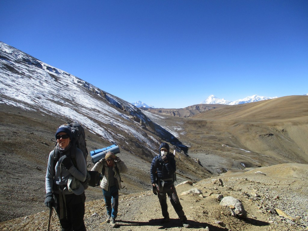
We found some locals traveling to Lo Manthang as well and shared the costs of a private jeep. It would leave at 3pm, so of course it would leave no earlier then 3:30. We hung around Jomsom a bit still feeling tired of the long drive. We bought some Dal moth and dried apples for along the way. We had not only brought a guide but a porter as well, meaning that our initial supply for 3 people was too few for the actual 4 people we were with now. In Kathmandu we had already bought a few additional supplies, but I still felt it was not sufficient.
At around 4pm (of course) we left for Lo Manthang. The terrain got spectacular pretty fast. Lower Mustang already contains some hints of what is to come, but as soon as you cross over to upper Mustang the real deal begins. The rugged canyons and colorful rocky mountains were stunning.
Though beautiful we still had trouble staying awake. It was already getting late and we really really felt like sleeping. As it got darker we hoped at each corner to finally see Lo Manthang. When we finally arrived it was already completely dark, it would be a surprise where we would turn out to be tomorrow…
It was a good hotel, more a hotel than a tea house. We ate our Dal Bhat and went to bed.
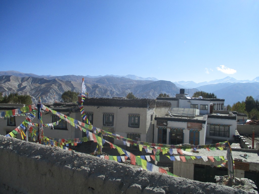
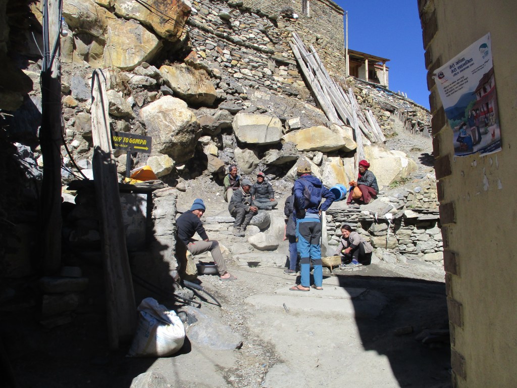
Our trek would take us high up right away, without any tea houses to support us. So the next day we spent around Lo Manthang to acclimatize . Lo Manthang is situated at 3850m, so already a worthy height to acclimatize. It was also an ideal place to spent an extra day. There are many sights to visit. We made a day trip to see the Luri Gompa, a small monastery built into a cave and went for an evening stroll through the old center of Lo Manthang. Lo Manthang is the only fortified city in Nepal and has quite some ‘7 years in Tibet’ vibes.

We discovered that Upper Mustang was growing popular among Nepalese people, who did a motor cycle trip to the Chines border. I could totally see why they did it. This must be an amazing place to ride a motor bike and the Mustang scenery is unlike any other place in Nepal.
DAY 2
Today we started our trek. Eline was a little nervous how it would go over, but the nice weather was very encouraging. We hiked south over the jeep track. After a few kilometers a small trail diverted from the road that took us over ridge to the village Dhi.
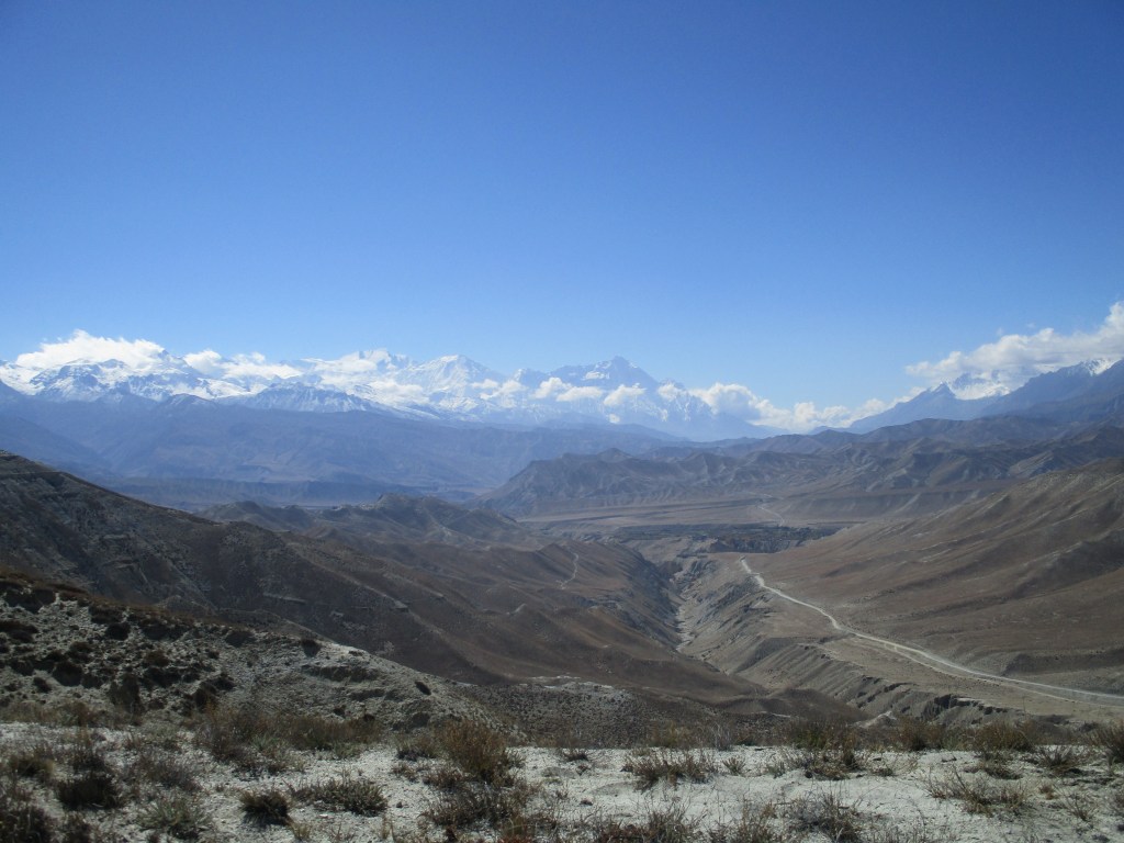
We hiked across a dusty dessert-like landscape. With the Himalayan peaks on our south east and The Dolpan mountains on our west. When we looked north we could see the Tibetan plateau stretching itself out in the distance.
The highest point of the ridge was about 4050 meters and we could already feel the altitude, our heavy bags containing all of our supplies for the trek ahead of us certainly did not help.
A short but intense descent brought us down into the canyon. Here we found the village of Dhi where we stopped for some lunch. The locals were very optimistic about crossing the Saaribung. Great timing with the season and weather they said. ‘You can cross’.
From Dhi we followed a side river up towards Yara. The last village we would see before reaching civilization again on the other side of Saribung. It was quite a long first day. And we were pretty tired when we arrived at Yara. It had also been a long day so we missed our opportunity to bake in the sun for a bit. Once we placed our bags in our room and went down to the village square the sun had already set behind the mountains immediately dropping the perceived temperature by 10 degrees.

We spent the rest of the day in the common room of the hotel. It was quite a nice hotel, Mustang made a very developed and well funded impression on me. Our host said that we were the first tourists since outbreak of the pandemic. So it seemed that like the Sherpani col we would again be the first team to make our way across it. Due to the intense snow of the previous week I was not too excited about that…
We spent the evening we watched an old lady spinning wool and drank butter tea at the fire. We would have t do without these comforts for a week to come.
DAY 3
We left Yara in the morning. We ate some porridge for breakfast, with some nice farm fresh milk. Probably a fatal mistake as would turn out later.

We hiked over the jeep track to Ghara where we too a very early lunch. Eline could not stop giggling about the fact that we were already lunching at 9:30. We ate outside in the sun. We had a good view over the rest of the route of the next 2 days. A long gradual climb to the kharka of Ghuma Thanti. It looked pretty dry and we informed about water along the way.
The lady told us of a location where there might be water, though not guaranteed. Since we needed an additional acclimatization day on the slope before reaching Ghuma Thanti we decided to get some extra bottles and carry additional water with us to last us a night. With this additional baggage we were hilariously over packed, but we were still fresh and we knew that we would walk short days in order to acclimatize well.
We hiked down to the river where we met a few locals packing up a kharka for the winter. We crossed the river, or more like small stream, and started our climb up. It was 1200 meters up to Ghuma Thanti, which we wanted to reach the next day. We hiked gradually up, now and then losing the poorly defined trail. After a steep climb we got to a large flat area that would take us to the base of the climb to the final pass.
Eline was not looking very well and moving slowly. It was her first time on serious altitude so we did not want to press it. We only hiked a little further and pitched our tent next to the bumpy jeep track heading for Ghuma Thanti.
That night Eline was soo hot I had to move away from her in the sleepingbag. It was as if she was boiling. We said she was nervous and had difficulties with the altitude. She had to set her mind right she said. For some reason we did not see the obvious fact that she was just ill.
DAY 4
Very early in the morning I heard 2 motor cycles coming down over the jeep track. I deduced this would be a good thing as it meant that there might be people in Ghuma Thanti making it possible to maybe spent an additional day there if needed.
As we were having breakfast Eline was not able to eat much. After a few bites of porridge she was out. From her face you could read that it had been a tough night for her. We could not really pin the problem, but as there was no water we did need to move further or go back. As it was way to early to give up we pressed on.
We hiked over the easy jeep track. But it was clear that Eline had it tough. After just 20 minutes or so it was clear we would not reach far. Luckily for us the point the lady in Ghara had told us might have some water indeed had some water. We pitched our tent next to the road and filled our bottles with the somewhat sad small muddy stream.
With the rather uninteresting terrain, poor water supply and Eline laying sick in the tent, this was one of the most demoralizing camps I can remember. I knew that another day here would mean that Ram and Bibic would start to pressure me to go back. I thought to myself to wake up early the next day. Maybe some motor cycles would go up again and Eline would be able to get a ride to Ghuma Thanti. If there were people there we could wait out her condition there in a nice environment with a food supply.
DAY 5
I woke up early and made sure I stayed awake. I listened carefully for sounds indicating someone might be passing by. And yes indeed something was coming. I heard bells and voices. There must be a mule train on the move.
I ran out the tent and stopped the locals with their mules who were heading up. Unfortunately the language gap was too big and they were too shy. They moved along without me being able to get Eline a ride.
I was very disappointed when they move further up. It felt like my chance was slipping out of my hand for no reason at all. A I sat there, there was however another mule train coming up. Due to the commotion Bibic had also waken up. This time with an interpreter on my side we were able to negotiate a ride up for Eline.
Eline, disoriented by the sudden change of events, put on her clothes and got on the horse. The locals would take her to Ghuma Thanti where she would wait for us.
After she left Ram quickly followed suit. He did not like it very much to have lost eye on one of his clients. Bibic and me had a bit of breakfast first and left for Ghuma Thanti with the bulk of the luggage.
The bags were insanely heavy, but when Ram called us telling that Eline was feeling better we did not feel this anymore. Cheerfully Bibic and eye climbed further up. On the highest point the jeep track made place for a trail. I was very happy with this, as I don’t like walking near to roads at all.

We met the mule train on their way back. I paid the horseman. Unfortunately it turned out that they had gone there to clean out the camp for the winter. They had been the very last mule train of the year. It would take until spring for people to go back up again. We had been very lucky with the ride, but were all on our own now.
Ghuma Thanti consisted of four huts situated next to a stream. Two of them were for cattle and two of them for people. The huts were open, so we did not have to pitch our tents.
Eline was looking a lot better and we were hopeful that things would go better from this point on. The fact that Eline felt better despite the fact that we were higher than the day before. And the fact that the obvious fact started to down on us that Eline had had a fever the first night camping. Finally made me fully certain that it was food poisoning and not altitude issues we were dealing with here. A good thing, as we would need to move way further up.
DAY 6
The day started out well, but with the first bite of porridge it went down hill. Eline did not feel well after eating and when we started moving it quickly got worse. Just after 5 minutes I already made the call to head back and wait another day. A difficult but necessary decision. Sometimes the best you can do is nothing…
The day before yesterday had been demoralizing, but today was even harder. We could not know whether Eline would recover fast enough. Bibic and Ram were bored out of their minds and we had limited food supply. I knew I could not convince them again to stay an additional day. All we could do was wait and hope. It was immensely frustrating.
Eline did feel better then yesterday, but still small things took her enormous effort. I had some hope but not much. I felt like Bibic and Ram were already on their way back in their heads.
We spent the rest of the day haning around Ghuma Thanti. To kill some time I hiked up part of the way to the Kyumu la.

DAY 7
Eline felt well enough to give it a try. And try she did! It was impressive and unexpected, but with a modest, but constant phase she was able to climb. For the first 20 minutes I was holding my breath, but after the first half hour it became clear she would be able to pull it off.
It was a gradual climb up to the Kyumu la. The small trail took us through colorful rock slowly upward. We had a nice view of mount Dhaulagiri behind us.
Once near the pass the wind started to blow. Even for tibetan standards it was rather intense. Bibic, Ram and Eline (who was walking up with an impressive speed now) found the wind chill so called that they did not even wait for me on top of the pass ;p When I was on top I already saw them walking down.

From the pass we could already see tomorrows pass, the Baksyak east of us. Just like the recent satellite imagery had shown there was indeed a patch of snow on the eastern flank. How wonderful is modern technology right?
Bibic was very happy, and was telling me about how great of an idea it was to wait a day in Ghuma Thanti, and how impressed he was that Eline had been able to cross the pass after having been so ill. He was young and full of ambition to complete this trek and use this experience in his guiding career.
As we went further down the wind weakened. At the first stream we took a well deserved rest and lunch. We felt happy. Just yesterday the entire expedition seemed lost and today we were sitting in the sun having enjoyed good views from our crossing of the first high pass.

After lunch we hiked down, down down. All the way till the Baksyak canyon. A nice flat place with a stream. I remember I had thought about potential difficulties crossing this stream. That seemed pretty silly now, it was more the lack of water here that could be a reason for concern.
There was a small improvised hut, that was in the season utilized by pilgrims. We used it to stay overnight. It looked dirty at first, but after some cleaning it was a great place to stay. I still have good memories of the cold clear night under the starts we had there.
In the evening I inspected our food. Despite our delay we had enough with us. Though it would not be haute cuisine.
DAY 8
We woke early. It was cold, but we could warm ourselves at the fire and with our oath meal. We were in good spirits. Eline felt well and the weather was good. We were not expecting any real challenges on our way to Damodar Kunda and were looking foreward to the day ahead.
The climb to the Baksyak pas started immediately. It was straight up for a few hours. About half way we could walk in the sun, which made the experience a lot better. The terrain got less steep as we neared the pass. At one point we thought we had reached the pass, but the trail took us further up.
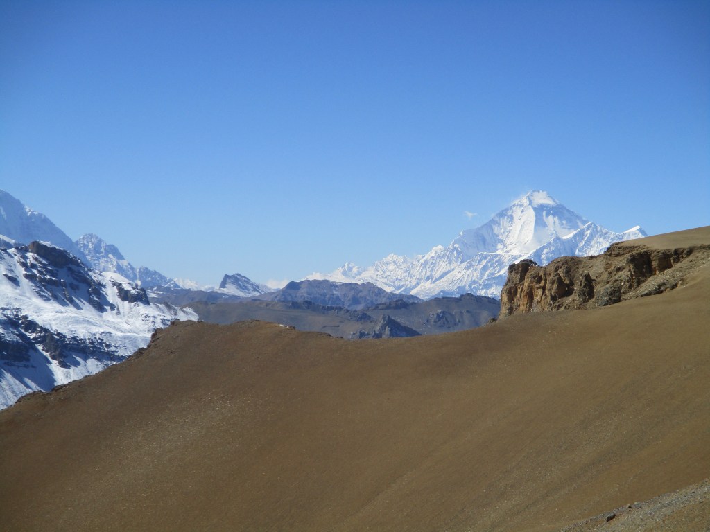
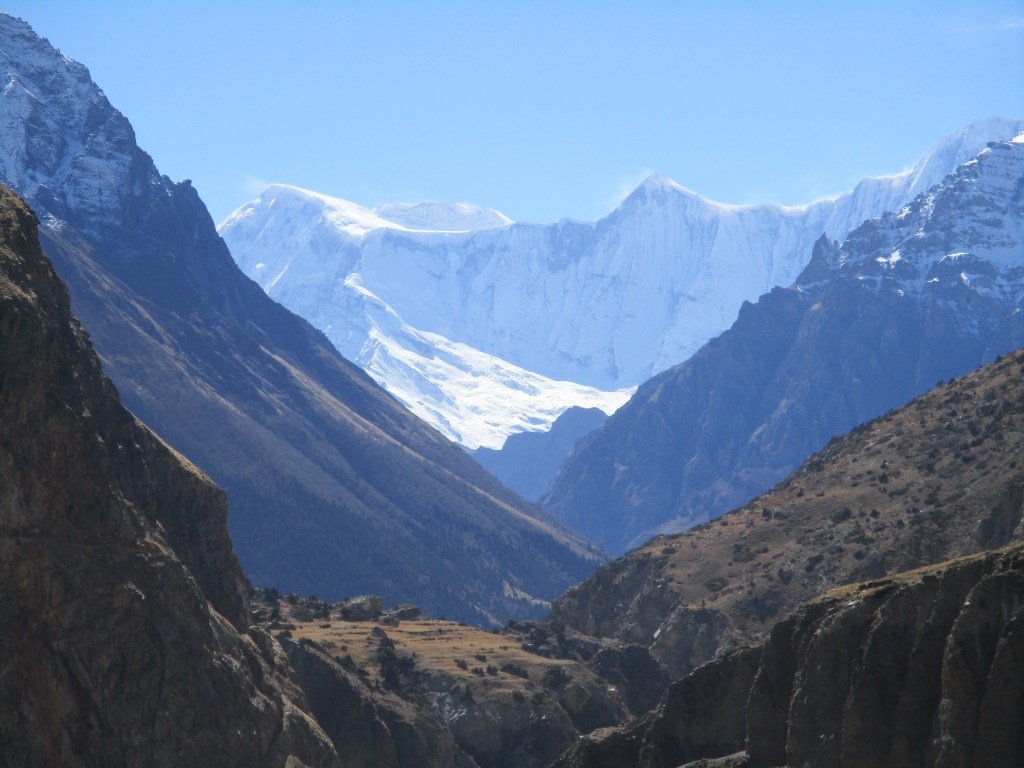
Once on the pas itself, we had a great view over the Damodar Himal south of us and over Tibetan mountain to our north east. We could see the Saribung glacier that we would need to climb the next day below us. The snow situation seemed to be somewhat under control as far as i could make out.
The way down was longer then we anticipated. The trail descended very slowly, but it offered good views all the way. Once we finally made it down to the stream marking the lowest point in the valley we had lunch. After that is was about an hour or so more to Damodar Kunda itself.
Damodar Kunda is a pilgrim destination and there were a few faculties around the lake. A small temple, some sheds and a trail around the lake. Since the pilgrim season is summer the place was however completely deserted apart from three horses grazing in the surrounding.

It was significantly colder then in the Baksyak canyon so we decided to pitch our tents inside the sheds. One last comfortable night before we would need to camp on the glacier itself.

DAY 9
We had no exact location in mind, but wanted to camp at, at least 5450m, to make crossing to pass next day feasible.
We followed a good trail up valley. I was curious how long we would be able to identify the route. Saribung is not crossed very often and glaciers have a tendency to erase a route quick.
The trail was less well maintained and land slides had wracked it in a few places, but it was better then I had thought. Around the afternoon we reached the moraine filled lower part of the glacier. It was easy going. A route was visible and marked with stones. Due to the flat terrain we covered a lot of distance in a short time.
On a broad flood plane the icy part of the glacier started. All of a sudden we could no longer make out the route. It seemed we were at the end of the easy going part of the trek. Two glaciers smashed into eachother. We needed to follow the western one. We decided to climb through the gully, between the two glaciers to get on top of the wester glacier. I knew we had to follow the wester glacier via it’s left (western) side. We had to make sure we did not end up on the wrong side as crossing the glacier would be a tough and time consuming undertaking.

Climbing up was difficult and slow. As we climbed further it started to dawn upon me that we had made a wrong choice. We were pushed to the wrong side of the glacier and would be forced to cross it to it’s other side at some point. As we climbed up further the stone made way for snow. Once we reached 5500m we pitched our tent on what we expected would be one of the last stone patches. I did not want to push our luck and climb up further, as sleeping too high might only weaken Eline.
While Ram, Bibic and Eline were pitching the tent I went ahead to explore the route for tomorrow. I wanted to hike up to a point from which I could get an overview of the glacier. It was further then I had hoped, but after 30 minutes I got to a point from where I had a good view. We were indeed on the wrong side of the glacier. From this viewpoint I could see that our lives would probably have been significantly easier had we climbed up the eastern ramp of the eastern glacier and then hiked across that glacier to the eastern side of the western glacier. But the situation was not hopeless, it looked like we could traverse the glacier and pick up the correct route after that.
As I hiked back, I had some difficulty finding back our camping spot. I really should have marked it in my GPS. It is funny how easy it is to lose yourself in glacial moraines.

As we expected a cold night, and since we wanted to pack up fast we all slept in one tent. We were a little nervous but in good spirit. We made jokes about the lack of sleep we would have and about how we were looking forward to reach Phu.
DAY 10
We woke up before dawn. Nervously for the tough day ahead we all ate a muesli bar. It would be the last thing we ate till sundown… Once we packed up in the cold we started to retrace my steps of the previous day. I had hiked quite a bit ahead yesterday and it took us some time to reach there again. From that point we could look over the glacier we needed to cross. It looked tough, but doable.
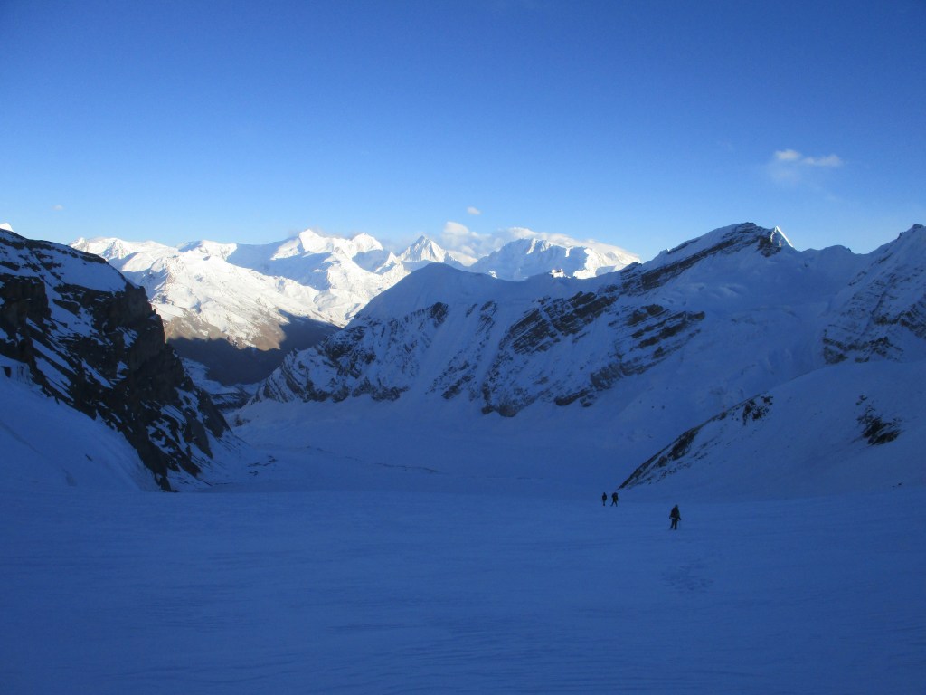
We put on our crampons ad hiked a little down to the glacier. First on the ice and then, unfortunately through rater deep snow. Ram, with his lighter backpack went ahead and we followed. We moved very slow and Eline was visibly a little nervous. It took us maybe over an hour to navigate through the glacier. Which was a literal maze of ice peaks and crevices. All the way at the end there was a very steep drop to get of the glacier again. It almost looked impossible, but with our crampons we were able to climb it down.

Now we were finally back on the actual route. It felt good that each step we now took was a step we had also planned to make. We were now at almost 5600m and the steps were exhausting. There was rather deep snow on the side of the glacier as well. I started to doubt whether we would make it today. I felt already tired and we were not even close. Eline looked like she had ran a marathon and unexpectedly would need to run another one.
Step by step the pass came a little closer. When the pass was just 2.5km away the route got easier. We could follow a rock filled ridge over the glacier. I knew this ridge from photos of other expeditions. I was glad we had some easy walking. We were able to hike 1.5 kilometers without any difficulty in under an hour. An amazing speed if you take into account that up untill then we had spent 5 hours to cover the same distance.

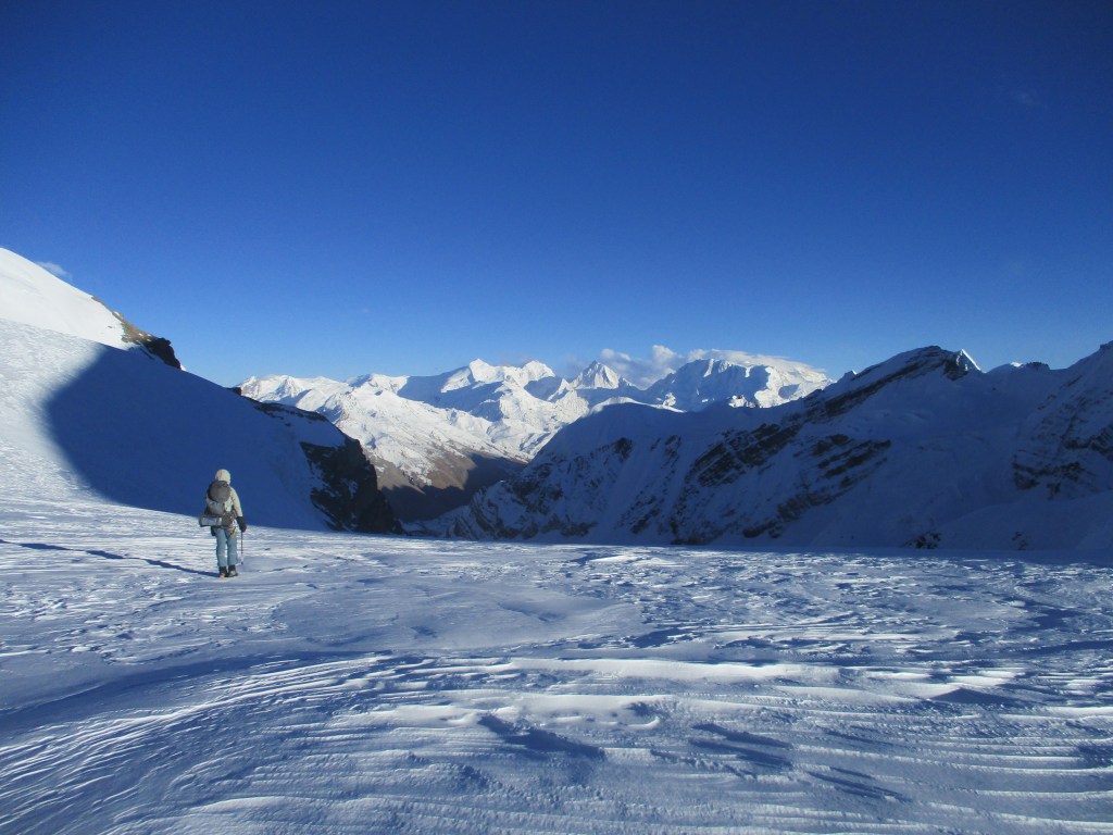
All good things come to an end however. The rocky ridge ended and we needed to hike across the glacier again. The snow was a little better however. We fell through only till half way our knee. Sometimes till our knee. Since we were now over 5800m this was very exhausting. There was a freezing wind that started blowing so we needed to be careful to protect ourselves from the cold.
We now saw the a saddle on our east. Ram was convinced that this was the pass, but I know from the maps I studied that it would in fact be the next one. Bad luck we would need to battle the snow a while longer. By now it was already 3pm, way later then I had hoped. But the pass was now really nearby and we had left the last reasonable camping spot behind us.
We were now at 5900 with the pass just 1km away. It was just a mater of climbing up the last snow slope. Easy as it sounds it felt like it took forever. Each time I looked at my GPS we barely made any progress.
But at some point at last the snow started to flatten out. We were almost there. I could only take 10 steps at a time, then I needed to catch my breath and set 10 more steps. Ram and Eline were a little bit ahead and were already on the pass as I set my lasts steps to the top.
The pass was very broad and all glacier. Ram said: ‘no flags! Only glacier’. I asured him that this was the pass and that we were on the right spot. He said he had never seen anything like this. We were cold and only took a very quick photo before descending again. The sun was already going down. I felt my feet getting cold. Due to the cold that day Eline and I had paid close attention to our feet and hands.
We hiked down quickly. Ram and Bibic wanted to camp of the glacier, but that was not realistic. That would be hours more. With the sun going down there was no chance. Besides our feet were getting colder and as the sun went down and the temperature dropped further we might find ourselves in a dangerous situation.
I decided to pitch our tent on the snow and all seek refuge there. A good decision as in the last minutes of pitching the tent, my shoes already started to freeze over. Once the tent was pitched we quickly went inside to warm our feet. I was happy that our feet seemed to be ok.
The tent was pitched on quite steep terrain and we were 4 people in a 3 person tent. It was really cramped in the tent. It easily rates as one of the most uncomfortable nights I have ever had. Most of the evening and early night I spent melting snow. We were very thirsty and it was hard to melt snow due to the very low temperatures.
DAY 11
Thank god, the night was over and the sun warmth our tent again. Today would be a better day. We just needed to hike down, and it looked doable.

We took our shoes within the tent and started to try and thaw them with our body heat. We ate our last muesli bar as breakfast. Ram had some bad news, his feet had been too cold for too long yesterday. He said he had difficulty feeling them, but he said it was a bit better then in the night and that he could walk.
We hiked further down. We camped at 5900m so we had not hiked down a lot yesterday. Eline was feeling quite weak due to the altitude, but felt better with each 50m that we descended.

There was no cold breeze today and it was warm in the sun. We slowly but steadily made our way down. The views were really good. A broad glacier with steep mountains rising up from all sides.
Ram and Bibic had hoped to reach Phu that day, but that seemed unlikely. We would already be lucky to make it off the morianes I thought.
At around noon we were off the ice and could follow the moraines. A little easier then snow maybe, but still challenging terrain. Eline felt a lot stronger then in the morning, but as the moraines would last for multiple kilometers I did not see us make it off the same day.
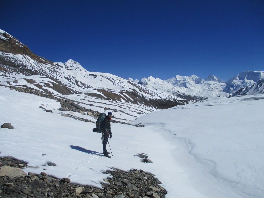
At around 3:30pm we decided to stop. I did not want to press on as there were very few camping spots to be found and I did not want to rush on. Tomorrow we would probably meet a train again on solid ground. Then we could press on to Phu.
We ate some porridge and mashed potato as it was the last thing we still had. Tomorrow we would need to try and make it to Phu, otherwise our menu would get even worse.
We enjoyed our superior camping spot compared to this morning. We pitched both tents again and from the tent door we could see the sunset on the mountains around us.
DAY 12
Eline had a very cold night as the sleeping bag was a little wet due to the previous night. We ate a big breakfast and set out. We were motivated to make it all the way to Phu, our food reserves were low and we were really looking forward to something tasty. Eline was mostly hoping for a nice warm bed 🙂
I was optimistic. It was far, about 15km brids flight, but the terrain would become easier and a trail should appear soon.
We hiked down over the gravel and boulder filled moraines. It was probably good that we had not tried to make it all the way down the day before. It took about 2 hours to reach the end of the glacier proper. We could see clear signs of large groups having camped here. We hung our own prayer flags and enjoyed the first view of real liquid water.
Despite what I had expected there was no real clear trail. Maybe the river had washed it away during the last 2 COVID years… We hiked the last stretch down to the valley floor and followed the river down stream via it’s northern bank. The terrain was flat and by times we could see a stone man, encouraging us that better times may be ahead.
Hiking along the gravel filled river was quick and easy. A small trail started to appear and we were in good spirits. After a while however the valley got narrower. And a small trail started to climb the valley wall steep up. We sighed. The trail was small, but clear. It was also sparsely marked with small stone man. It was clear we had to go up. It brought us 50 meters steep up, after which it took us down again the a side stream. From here it once again climbed very steep up for about 150 meters. Once on top we reached a flat grassy area with a very broad trail. Yes! it would be easy going from now on 🙂
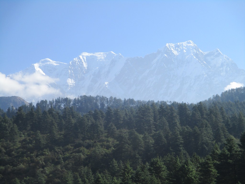
The trail was of my favorite type. It was a nice broad trail the kept altitude along a steep slope. Granting us both easy and quick hiking as well as great views to our south. Mount Himlung dominated our view and signaled we were getting ever closer to Phu.

Silently I was hoping that there would already be people in Phu Phedi. About 5km short of Phu. The map indicated some houses there. It was a Yak herding place that might be deserted, but also might have some people around.
Once we got closer to Phu the trail by times completely disappeared due to enormous landslides. These landslides had demolished several hundred meters of trail and were by times quite hard t navigate. But after what we had seen thus far it was just another day in the office…
At around 5pm we reached Phu Phedi. It was a nice place. We saw some yaks which made us hopeful, but as we got closer it was clear that non-one was there. We looked around the overgrown fields and ruins. Contemplating our options. We would not reach Phu before dark, that was clear. On the other hand Eline, Ram and Bibic really wanted to reach there. I did not mind camping another day much, but hiking further seemed fine as the trail would likely be in good conditions making hiking at night possible.
We decided to go ahead. We crossed the small stream and a nasty patch of ice there. From there on it was smooth sailing. We hiked fast. We had Dal bhat on our minds as we hiked up 200 meters in under 30 minutes.

Once on the highest point the trail kept altitude for 2 kilometers. We came past some nice stupas and had views all the way back to the Saaribung. As we looked back it seemed hard to believe we had been all the way up there. The Saaribung from here did not look much like a pass, but just as a high ridge between mountains. It was not much lower then the peaks around it.
Once we finally started to descend the sun also started to set. As usual around the equator it got dark quick. Eline did not like it one bit. Understandable as even now just 1.5km before Phu the trail was surprisingly poor. Ram and Bibic had already gone ahead (they really wanted their Dal Bhat). We had a head light and walked slowly through the dark. One time retracing our steps a little as the trail had become so narrow that we started to doubt we were still on it.

At some point we saw a light flashing in front of us. It were Bibic and Ram who had gone back for us. They told us we were really close now. My gps indicated the same. The village should be only 500m out, but even then it was nowhere to be seen. Only once we were directly next to it, you could see some dim lights. Without electricity a village does not make much light…
We were showed our room where we fell down on our beds. It was not even that late. Just past 7pm. It looked like a comfortable lodge and we were happy that after all these days, all these passes, all that snow and after the long day we could finally crash. I ate my Dal Bhat as if I was a castaway. It made Eline laugh, who had eaten almost nothing the entire trek, but somehow managed to not even be that hungry… I don’t understand how she did that…
DAY 13
Today was a rest day in Phu. We had the time and the last thing we had wanted yesterday is rushing on. Yesterday had been a long enough day for all of us. We had expected a day of relaxing, but when I heard Bibic on our front door in the morning we realized that we were in trouble. Rams feet had started to hurt, and got a very worrisome black look. A climbing guide had told him he should get immediate helicopter rescue. It was a nasty surprise when we found out that Nava had insured the health care of Ram and Bibic, but not a helicopter rescue. So it seemed we were in stuck. I did not want to pretend that I had fallen ill and make my insurance pay. In the end it turned out we got ‘lucky’ On of the climbers back from their Himlung ascend also had a frostbite and also needed a rescue.
Later that day it turned out that the luck of hitching along a helicopter rescue was not even that accidental. Phu was filled with climbers trying to ascend Himlung. Due to the especially cold year many of them had needed rescues. Once every few days people had been evacuated from the mountain. We understood that out of 10 climbers 3 ended up in the hospital this year. Typical expedition climbing…
Once Ram was picked up by the Helicopter and flown to first Chame and then Kathmandu. We could rest a bit. We spent the day around our lodge, exploring the village and eating actual real food.
The lodge was filled with climbers busy with their expedition on Himlung. As is typical for climbers they were fully obsessed with climbing it and had eye for little else. Did you make the top? How fast did you reach it? How many of your fellow climbers needed a rescue? It was pretty unearthly to witness. Eline was completely done with it by the end of the day. She wanted to stay in Keylong instead of Meta (the normal next stop on the route to Koto) just in order not to have to hear these stories again.
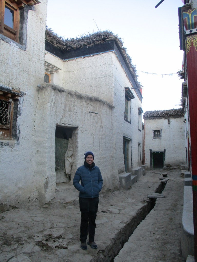
Phu was quite a stretched out village with many houses. Though the houses looked a lot like ruins by times and some had been deserted. It was built in Tibetan style, but had some more southern influences as well. It was one of the nicer mountain villages I have been to and it might have been a well worth destination in itself.
In the evening we received good new from Nava. The doctor had examined Rams foot. He had said it would take some time to recover, but that he expected no permanent damage. That was a big relief for all of us. The dark cloud that lifted a little and we could enjoy or Dal Bhat a lot better at dinner.
DAY 14
It would be a short day through the Naar Phu valley back towards Koto. It was a short day on purpose. We had the time and wanted to avoid Meta as Eline could not take any more climber stories.
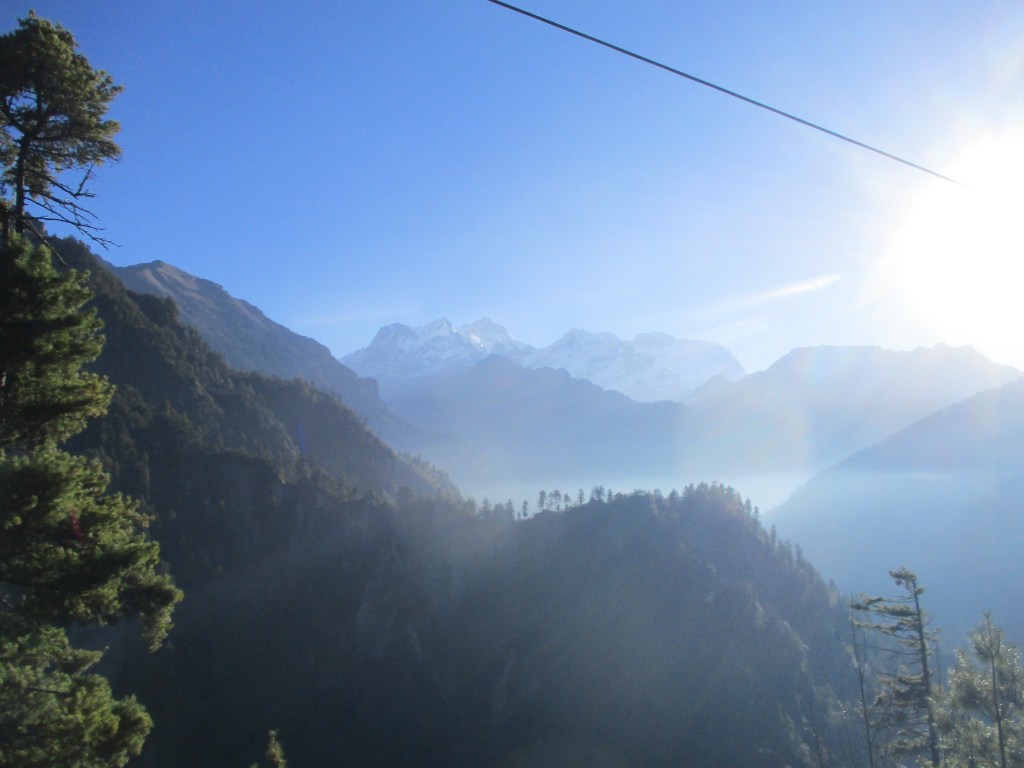
We had placed most of our camping gear in the helicopter with Ram so with almost empty backpacks we hiked down over an easy trail in the sun. The views were really good, better than expected. The landscape was extremely varied. We could see the first trees, brown rock, nearby glaciers and the far away Annapurna massif at the end of the valley. Today was the most enjoyable day of the trek. All difficulties lay behind us, the only thing we needed to do was enjoy the weather.
After about 2.5 hours we arrived at our lunch places. We ate some noodles at a small lodge. The views were so good from here that we considered spending the night. But we decided to hike a little further to Keylong.
Keylong had multiple lodges to choose from. We stayed in, of course, the first one we got across. It was still in construction, but oh well. As soon as the sun sank behind the mountain tops you remembered that it was already November and we spent much of the rest of the day around the fire in the kitchen.
DAY 15
Today we would descend down the tree line again! First we hiked in about 2 hours to Meta. Meta is small village with quite some larger hotels. In contrast with what we had seen so far these hotels were made with wood instead of the more Tibetan style stone architecture we had been seeing thus far.
After Meta we had to descend a steep 500 meters. The descend brought us down to the river which had carved a deep and long canyon of about 15 kilometers long. As we descended down to the roaring river we encountered pine forests and bamboo forests, a big change in scenery. Because the canyon was so steep and narrow no people were living here. We kept on following the narrow trail carved out in the rock through the dense jungle and along the many waterfalls. At each turn we hoped to spot the lodge that they said should be here. But each time nothing could be seen.

As time passed we started to assume that we would need to hike all the way to Koto today. But at around 4pm we did reach a few wooden buildings. We though we were there but we had to walk for another kilometer to find the lodge we were looking for.
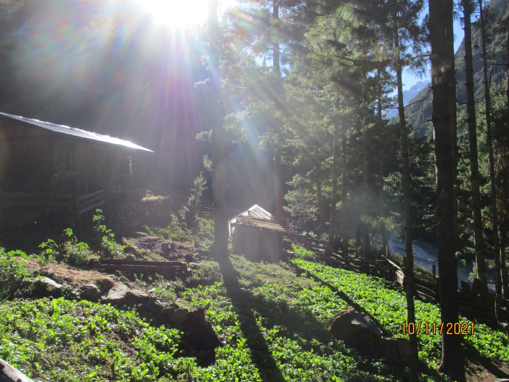
The lodge had a wooden house that was the kitchen, a terrace with roof, a vegetable garden and a dorm where we could sleep. Sitting on the terrace we could see the vegetable garden and roaring river below us. The sun shone through the large pine trees. It was nice to be along the trees again after so long in ice and rock.
DAY 16
It was only 3 more hours to Koto. The very last section brought us through the steepest section of the canyon. The trail was by times literately carved out the perpendicular rock.
Koto is a small town next to the famous Annapurna circuit. It is full with colorful houses. But now the jeep track, it has lost some of it’s authenticity as a lot of non locally sourced building materials have been used. We spent some time looking around the shops and finding a good place to get lunch.

We were looking for a jeep to take us to Besisahar, a larger city from where you can travel to Kathmandu by bus. But it seemed we had to wait till the next morning. So we packed up our backs and hiked a kilometer west to the bigger town Chame to find a hotel. Here we found what you can consider a true hotel. A large concrete building with wifi and a dining room. Sitting in the dining room looking at the jeeps that passed by I did wonder why people would still be doing the Annapurna circuit as a trek. There are so many treks one can undertake in Nepal, there seems to be no real point in insisting hiking along a dusty jeep track just because there was a trail back in the nineties.
In Chame we could clearly see signs of the extremely heavy monsoon of this year. There was a hotel that had been splitted in half due to a landslide. And in the hotel there was still no electricity as the network had been too badly damaged. Living and building in Nepal means a constant fight with the environment…

DAY 17
I hade done the drive before. Back then I had done it with Dennis on the way back of a 2 months trek through Mugu, Dolpo, Dhorpatan and Dhaulagiri. I remembered the road to be rough, but due to the rater devestating monsoon it looked even rougher than before. There were just so many fresh landslides.
We had good views over the last mountains near Dharapani, near to the start of the Manaslu circuit. After that we descended to lower altitude. I became warmer, and then it became hotter. It was a long drive but around the afternoon we reached the city Besisahar.
Besisahar was a completely different climate zone and the first large city we encountered since we had left Kathmandu. We bought fruit, food and I got my beard cut. The hair dresser was so precise that he did not leave a single hear on my face… I think I sat there for 20 minutes praying for it to end. All the while being laughed at by Eline…
From the balcony of our hotel in Besisahar we could just see the last 2 snowy tips of the Manaslu range. Looking at them brought me back to the adventurous of the last month and of all the ones that I have had in the Himalaya before. I count myself lucky that I have been privileged to make so many great treks through this mythical mountain range.
