August 2023
Pitoravik – Clements Markham – glacier – Ice cap – Brother John glacier – Etah – Kap inglefield – Brother john glaciar – ice cap – Clements Markham glacier – Pitoravik
When I think back of how I got into trekking. I realize that it was actually not because of my desire to explore the world on foot. Rather it was due to my dream to visit the high Arctic. The idea of visiting very northern top of our planet with it’s ice covered waters captured my imagination. After my final exams I had therefore initially planned to head to Svalbard by boat with my grandmother, but due to high costs we decided differently and went to Lapland instead. As an alternative I found an affordable group travel to Svalbard that explored the island on foot from Longyearbyen that I could join for the next year. In the end this trip did not materialize due to there being too few participants and I was rescheduled to eastern Greenland instead. This in fact was my first ever trek. Thanks to this trek I discovered how great hiking expeditions were and this first trek formed the basis of many more to come. What started out as simply the most affordable way to visit the Arctic turned into probably my greatest hobby.
Over the years I made many treks in many amazing places, but actually never in the high Arctic, the place that actually got me into trekking in the first place… My dream to go to the high Arctic therefore lingered on. I had looked into treks in the high Arctic many times before. But trekking in this region means high transportation costs, difficult logistics and being well prepared for polar bears. I therefore time and again decided against it. But in 2022 after a decade of trekking experience I decided the time was finally there.
I chose Inglefield land in northern Greenland as destination as it seemed to have varied landscapes, was somewhat easily accessible and had no permits or red tape attached to it.
Inglefield is located between 78 and 79 degrees north and is one of the northernmost landmasses on earth. It lies at the edge of the permanent sea ice where the Smith sound strait enters the Kane basin.
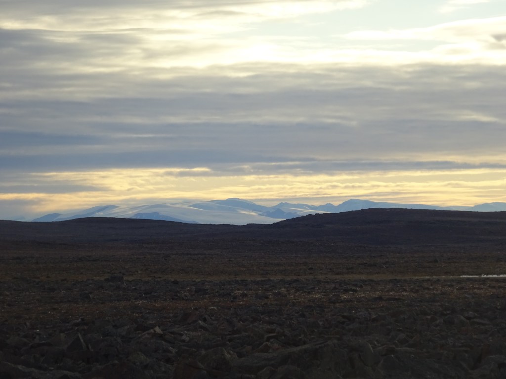
In summer the ice breaks meaning that marine wildlife such as Walrus, Polar bear and Narwhal are plenty. As far as the high arctic goes the landscape is quite varied (though inevitably empty). There are many glaciers terminating in the sea from the ice cap and there is the typical vast empty rock planes with cliff like table mountains that characterize most of the high arctic. Inglefield land also has a few sheltered fjords harboring plants that can somehow survive these harsh conditions giving a rare sense of greenery from time to time.
We were supposed to be dropped off at the northern coast of Inglefield land and make our way back to Pitarofik. There was however a lot more sea ice than usual. The locals had not seen this much ice in 20 years, so it was not possible to go further north than Pitarofik let alone make it past cape Alexander. We were therefore dropped off at Pitarofik and headed to the north coast from there after which we looped back to Pitarofik again. Covering around 170km in total.
On the way to Qaanaaq we made a stop over in Illulisat, probably the most famous spot in the whole of Greenland. We added a 2 day (which should better be done as a 3 day) side trek to explore the famous ice fjord.

Videos
Getting there
Reaching Inglefield land is kind of an expedition in itself… The first step would be to fly to Kangerlusuaq Greenlands international airport. Kangerlusuaq is not really a village or town, the location was purely chosen due to it’s favourable weahter and terrain. So from Kangerlusuaq you would next fly to either Illulisat or Upernavik which are actual towns. From there you can go on to fly to Qaanaaq. Due to transits and delays due to the weather (on the way up we were delayed by 3 days due to fog) reaching Qaanaaq can take a long time. Our way up took 5 days and our way back 3 days. It is also quite expensive since you need multiple flights. It is twice as expensive as visiting most other places in Greenland.
From Qaanaaq you should charter a boat to drop you at Inglefield land. Ice and wind conditions can make this quite hard. We were not able to reach it by boat, but usually if you have a few days to wait out bad weather you should be able to reach Etah in 1 day or the north coast in 2 days from on the last week of July.
Packing list
It is a full camping trek. Due to the high risk of polar bears a riffle is absolutely necessary. When crossing any of the glaciers or ice cap you should bring good climbing gear. Crossing the ice cap is not very difficult but it certainly requires technical gear. We actually had to get someone of our group out of a crevice.
Season
July and August are the only 2 ‘warm’ months. Though we have felt warm on only a few occasions. The temperature is just 3 to 4 degrees and as soon as the sun is hiding behind the clouds or there is a bit of wind it gets cold real quick. We spent most of our time hiding in our tents… I found out that there was a real difference between the high arctic and arctic summer climates as I was used to eat together outside when the sun is out. But here we only ate outside once.
Between October and May you can reach Inglefield land by sledge from Qaanaaq both via the ice cap as well as over the sea ice.
Day 1
The forecast did not promise much good. During our 3 day delay in Illulisat the weather was fine, but we had already seen that from today onward the weather was predicted to be bad. Rain was predicted for 5 days running and even after that it did not look too good… This, to say the least, did not give us a good mood while starting the trek.
As we arrived in Qaanaaq the weather was indeed rainy. Coming from the green Illulisat region near the polar circle over 1200km south Qaanaaq felt like an extremely desolate place. Even the smallest of plants clearly had difficulty maintaining themselves in this harsh environment. The slope behind Qaanaaq had remarkably little vegetation. The rain definitely did not help make this place look more hospitable.
We were picked up at the airport by our contact Saki who drove us to a camping spot near the village. We quickly pitched our tents and went in to seek shelter. A routine that would become all too common in the weeks to come.
We had a preparation meeting at Saki’s house. There we met Otto our main guide who would be responsible to drop us off in Inglefield land and pick us up again in Siorapaluk. Aside from immediately negotiating for more money then we had previously agreed on he also seemed unsure whether he would be able to make it all the way up to Inglefield land.
There was way more ice on the sea than usual. Normally Inglefield land should be reachable by the end of July, but this year the ice on the fjord itself had only broke 2 weeks back and the Smith sound straight was full of ice. Depending on the wind this could easily block our way northbound.
We had decisions to make in how much risk we were willing to take when it came to getting stuck in the ice. If we would get stuck multiple times and spent many days to reach Inglefield land we would need to pay extra for each day. We paid for a 2 day trip north bound and decided that we could at maximum stretch that to a 3 day trip, but not more.
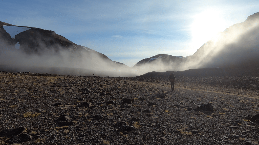
As we headed north by boat the next day through rainy weather it started out good. Real good actually, aside from some icebergs there was no sea ice or growlers in sight. Otto already went as far as to give us a thumbs up. However as we past Pitarofik the situation changed. It changed abruptly and completely. All of a sudden we found ourselves completely blocked by growlers everywhere.
Making it all the way to Etah all of a sudden seemed unlikely. The very high winds of yesterday at pressed all the sea ice to the region it seemed. Otto tried a few places but we kept getting stuck. We went on land and climbed a small hill to see if there any routes across. On top of the hill it was clear that Etah was just not going to happen, the ice towards the north only grew thicker and we would need to change plans.
I knew of a small beach south of kap Alexander from where we could make it to Etah in about 3 days without needing to cross the ice cap. It seemed that if we stayed close to the coast we might make it to there. It was just 12km further north and we could actually see the mountains from where we were standing.
Otto made a few attempts but we could not get around the large growlers blocking our way. The tide was low and we planned to wait a while for the tide to rise again. This could give some more space. A bit more space is all we needed as at the thinnest point there was just about 5 meters of ice blocking our way.
After about 15 minutes Otto however started to worry, there was more and more ice coming and he was getting concerned whether the way back to Qaanaaq might get blocked.
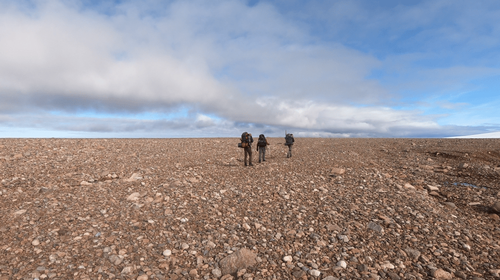
I was a bit disheartened. The weather was poor and predicted to remain poor and it seemed like we had to cross the ice cap ourselves to reach Inglefield land. Worst of all this meant we could not make a food drop and had to carry 17 days worth of food all the way. Our backpacks would be out of this world heavy. Together with the riffle our bags might weigh up to 35kg. Which is just an enormous amount to carry through tough terrain…
We were dropped off near the Clemens glacier. Our bags and us were carried ashore. We got a 30-06 riffle with around 25 bullets. The riffle was pretty rusty and looked like it had been dug up as a WW1 artifact. But as Otto sailed away and we tested the riffle it was working fine! It made a boom that made our ears ring. We felt like this should keep curious bears at bay.

So there we stood on the beach. In the rain with a rusty riffle and a lot of stuff that had to somehow fit in our bags. I had intended to drop the bear vaults at the head of Faulke fjord so they were laying around separately. It was 4 bulky cans weighing around 7kg. I feared we might have to carry items by hand the first 2 days…
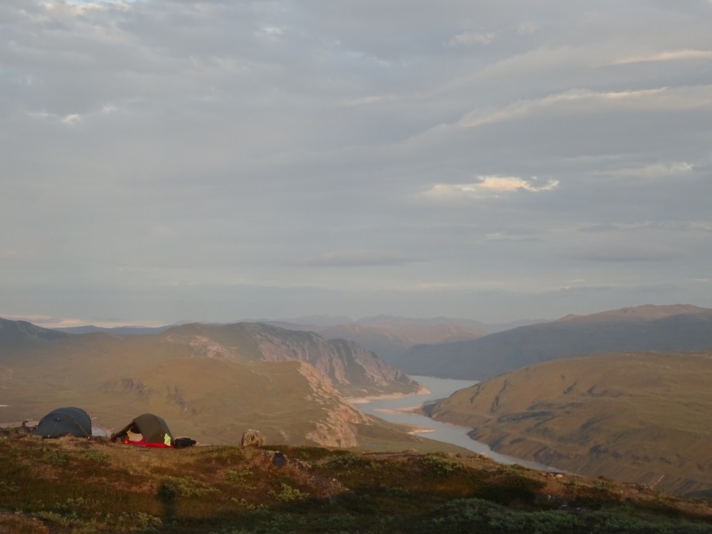
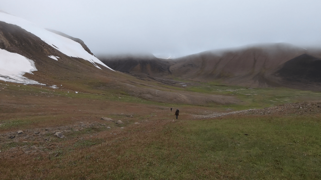
However to my amazement, somehow, all that stuff fitted in our backpacks. Well, fitted.. Our backpacks looked like huge towers with a lot of stuff hanging on all sides and all kinds of bags stacked further on top of it. There was a medium glacial river between us and the glacier. (Ugh if Otto had just dropped us off 200 meters further south we would not have had to cross it) We decided to cross it today so that we did not have to do so tomorrow. Once across we hiked up glacier to a point where from a distance it looked like we could camp on the western side of the glacier in the moraines.
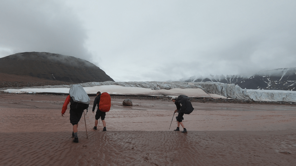
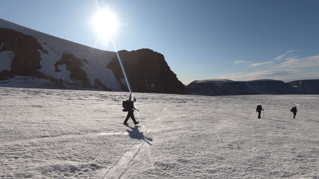
I have never ever hiked which such a heavy back. The beach and glacier made for easy hiking, but the packs were so heavy that I had instant muscle strain at every step.
I was truly grateful that glaciers started here right from the beach so that no moraines had to be crossed. The glacier itself was rather flat and had very sturdy ice. That was the one reason why we could make it to our first camping spot without collapsing.
Day 2
Today was forecasted as cloudy but not rainy. That gave us some hope! In the morning we burnt about 2kg of superfluous material. Last night we also had eaten our heaviest food so we were a few kg lighter. Both of those things going for us we started the day with confidence!
Our goal would be to follow the Clemens glacier up till it’s source at the icecap. If the glacier would remain this good all the way it would not be hard to do. The only thing that got Rose and I worried was the snow conditions on the ice cap itself. If there would be a lot of soft snow we might have a difficult time with our heavy backpacks. But there was no other way… We would take the shortest route over the icecap, but that still entailed about 40km of ice to go…

We made quick progress and though cloudy the weather was not too bad. At lunch time we had already covered around 7km. By times we could see the ice cap behind the mountains north of us through a gap in the clouds. We could not see the whole way up as it started to cloud up further, but it definitely looked like we would need to cross some fresh snow.

At around 500m the sturdy ice already had some 10cm of fresh snow on it and as we progressed it only got worse. At around 600m the first crevices started and we roped up. We now entered the clouds and it got harder to navigate. As we progressed the gradient of the terrain got less and less and we had to use the Garmin Inreach to make sure we were heading in the right direction. As the weather, visibility, snow and crevices all got worse we decided to set up camp. We had hiked about 9km and had climbed up around 600m. That was not bad at all.
As the snow started to fall and the weather clouded up we found ourselves camping in a white void. A white void, it would turn out, that would last for a while.
Day 3
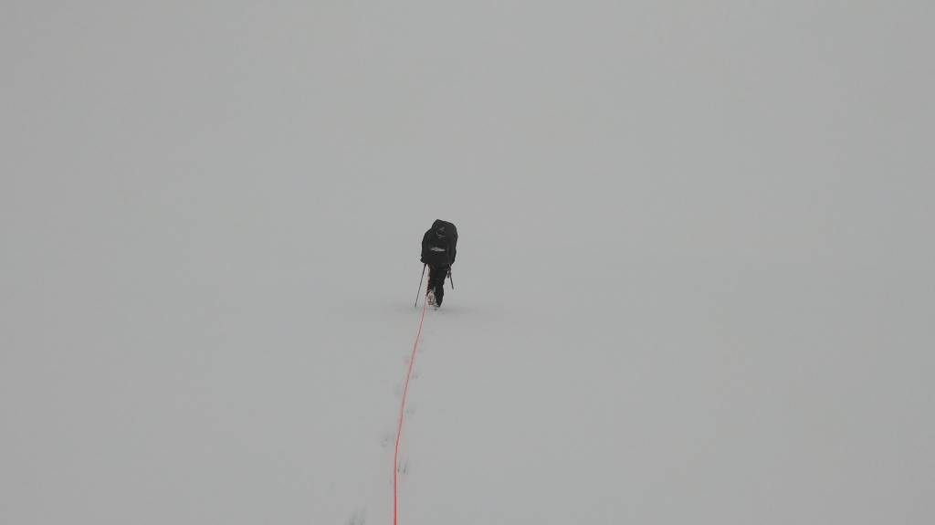
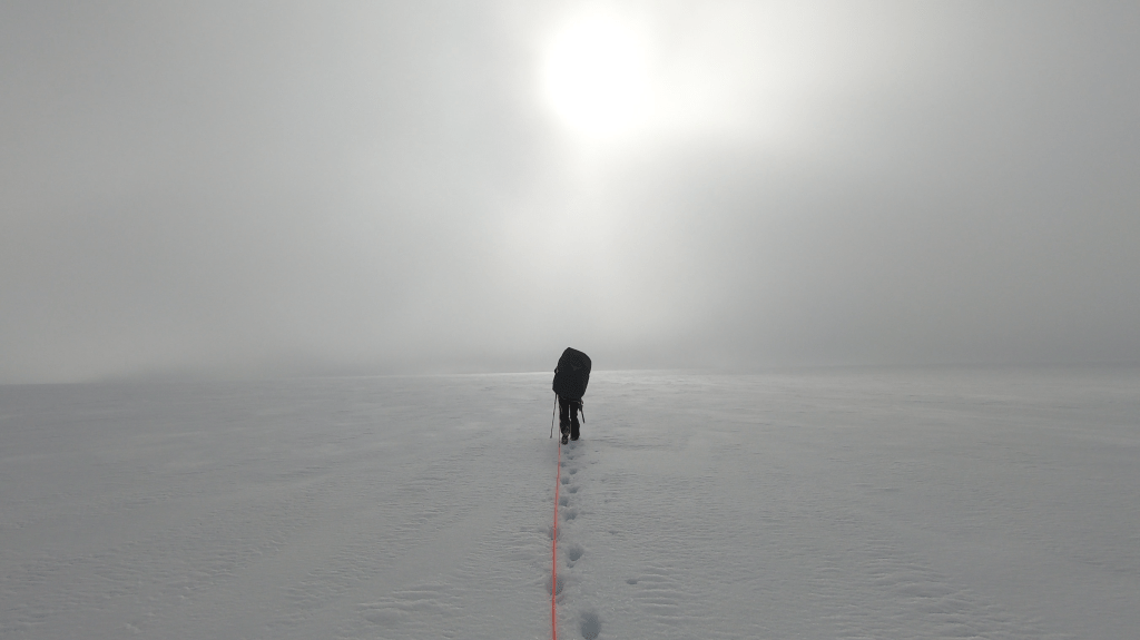
It had been our first day on the ice. Rose and I had by now spent so many nights on ice that we were almost accustomed to it’s discomforts. What I was less accustomed to though, was the thick mist around us. You could literally not see anything. Just pure white. You could not see where the ground gave way to the sky and vice versa. You could barely see the ground right in front of you. Due too everything being white all details simply disappeared. If you set one foot in front of another it was in pure faith that the ground had to be somewhere. Sure I had seen mist before, but here on the ice cap, with no details on the soil and no gradient in the terrain it was something else. It was extremely disorientating. The mist did not look like it would clear up any time soon and we knew that a major storm would hid on Monday. This meant we had no option but to continue our way through the mist. (trust me you don’t want to be high on the ice cap in the middle of a storm) Hiking in a straight line was very hard. The second person on the rope had to constantly check the gps and yell ‘left’ or ‘right’. This way we slowly but steadily zigzagged our way north west.
There were quite a lot of crevices, which together with the fresh snow and poor visibility made the whole situation quite hazardous. Each time it would start by the one in front believing he or she saw some detail in the terrain far ahead of us (though in this whiteness it is easy to imagine these kind of things). But then it would turn out to be a crevice just 10 meters in front of us. We tried to avoid the crevices as well as we could but had to cross multiple snow bridges. Each time I was hoping the hardest part was behind us, but with no visibility I had no clue what would be causing the crevices and where we were with respect to them. Were there crevices all around? Did we have a particularly bad spot? There was just no way to know. After a few hours of traversing this terrain Rick fell in a crevice. He was about half a meter in the crevice but we had luckily no difficulties getting him out. I was tempted to set up camp to calm down and hope for better weather. But the reality was that we had just barely done 5km at that point and to make it off the ice cap before Monday we really had to do at least 9km.
Luckily for us the terrain got a lot better about 20 minutes after Ricks fall. The snow was less deep and there were no more crevices. All of a sudden we could hike over 3km an hour and we made quick progress. We hiked around half of our distance that day in the last 1.5 hour…

We pitched our tent in the disorienting void and hoped for better weather. For the first time I invoked the forecast functionality of my Inreach, without having much hope. But it had good news. Next day around noon it would start to clear up and the next day the weather would even be really good. I could not believe what I saw and instantly felt a lot better. The mist and snow had felt permanently but now we had prospects to have great views it all felt a lot less pointless.
Day 4
It did not look like the weather had gotten the forecast’s memo. Visibility was near zero and it had snowed rather heavily in the night. Our shoes were frozen and our tents were snowed in with about half a meter of fresh snow.


However as we marched on the weather did improve. And at some point we could. At last. See the the horizon. We could almost not believe it. But there it was, the point where the snow touched the sky, it had been 48 hours but we could finally get a sense of our surroundings. Our surroundings turned out to consist of an endless plane of flat snow. It is clear why you would hike in circles in the mist, there was literally no landmark in sight.
We continued on using the compass of our Inreach to point us in the right direction. By times our feet fell through a very narrow hidden crevice, but nothing compared to what we had seen and too small to actually fall into.
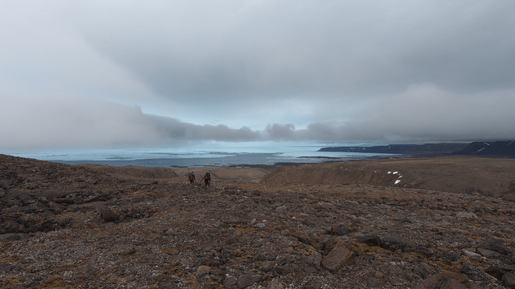
The meteo kept improving and as we pushed further west we could see the end of the ice cap! A few brown mountains and later on even the sea in the far distance below us.
We sat down for our afternoon snack enjoying a bit of a view for the first time. The landscape was so alien that I had to explain to Rick what we were actually seeing. The sea was full of ice and looked like a misty cloud and the barren mountains looked like gray rainy clouds. Below us we could see the mighty Storm glacier flowing down from the ice cap to the sea. Cape Alexander should be in the middle of this glacier, but was still hidden in the clouds. This was a big step, we now rounded the cape and were in Inglefield land! North of Smith sound. Not bad at all.
Unfortunately for us the way got tougher again. We had hoped that we could march on the way we had done today and the last part of yesterday, but as Rose said ‘nature throws you curve balls’. The snow no longer fully held and there was lots of water under the snow. It was like the ice cap could not quite decide wheter it wanted to be ice or water here. Resulting in a terrible slush puppy. Sometimes we fell through the ice to be in knee deep water. There were no crevices here where the water could escape and the terrain was not steep enough for the water to easily flow to the sea.

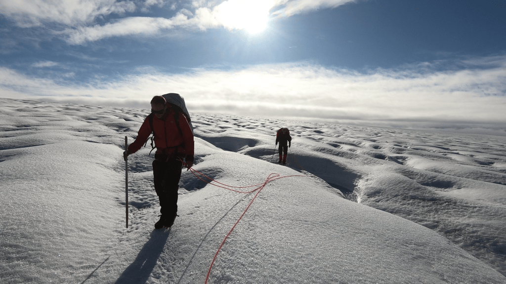
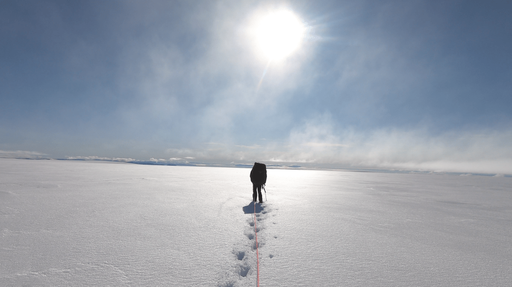
We ‘waded’ across the glacier for about 2 hours more before we set up camp. At this point the weather truly cleared up. A magnificent sight. We could see far and wide. I estimate that we could see the southern tip of Ellesmere which lay about 250km from us!

It was unbelievable how far we could see in the clear polar skies at this altitude. It must have been one of the beautiful sights I have ever seen. We could see the ice filled ocean below us stretching out to Elesmere island, where dozens of glaciers tumbled into the ocean. Elsemere felt like a stone throw away, even though in reality it was over 50km from us. The skies were so clear that for the rest of the holiday I was often tricked in seeing a nearby mountain that was not supposed to exist, only to realize that I was looking at a far away mountain in Canada.
Day 5
The weather was still splendid and especially when the slush puppy made way for firm ice I truly enjoyed the final kilometers across the ice cap. We followed and hopped over glacial streams to the great brown plains below us. All the while having the magnificent Elesmere island in the backdrop. This was what I came here for, this made up for all our hardship of the last days.


Slowly but steadily we go to the edge of the ice cap. Once there we had a small celebration. It always feels great to get rid of your technical gear and have solid ground under your feet again.


We made it! We made it to inglefield land. It looked as I had expected. Pretty much a rock dessert wit one or two tiny plants every once in a while. There was a brown stone dessert on our left and a white snow dessert on our right.

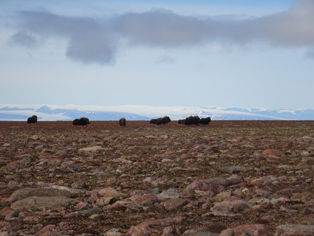
It was just after a few minutes that Rose spotted a few black dots in the distance. They looked like musk ox. Would it really be? We had just been here for 15 minutes would we really already see our first wildlife now?
The black dots were too far to determine what it really was, but we went of course to inspect it up close. You can truly see long distances here as it took us ages to get close. We even needed a small break for a snack to before we got there. But as we inched closer and closer we got more and more confident that they were indeed musk ox.
And indeed musk ox they were. It was an amazing sight. A medium sized flock with calves. Elesmere was in the backdrop giving us some really nice photo opportunities.
One day of good weather and the holiday already felt complete…


We hiked a bit further to a lake that had formed at the edge of the ice cap. At this point our backs were too tired due to the weight. We could not go further. We also did not have to. We could easily make it down tomorrow via the brother John glacier. Tomorrow wind would start to blow hard, very hard, so we would make it precisely in time.
Day 6
As we woke up the wind was already gaining strenght. By the time we packed our tent we had to be really carefull not to lose any gear. Especially losing the tents to the wind would be a disaster. In the end we did lose a matress. It blew out of the tent. I chased it, sprinting after it like a mad man. I gained a little ground on it for a moment, but I simply could not catch up. The wind had free reign, there was nothing but flat plains. There was nothing we could do as we saw our mattress blowing further and further till it went over the horizon minutes later. We had an extra mattress with us, so it did not matter too much, but it was a warning for us not to let go of anything. This wind was not a joke.
I knew there would be storm today, as Saki had informed me. But even with that in mind the strenght of the wind surprised me. We were at 600m on a wide open flat plain and the wind was strong enough to blow us over. I was really gratefull we could descend down to Faulke fjord today. That would probably be the most sheltered part in the whole of Inglefield land.

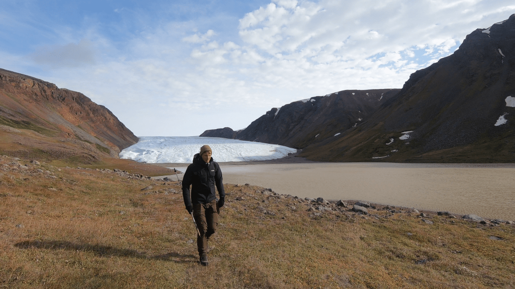
As we went down the rock slope down to the glacier the wind immediately decreased. That was a delight. All that was left would be an easy stroll down the Brother John glacier. The high arctic was truly different from the low arctic or Himalaya regions where glaciers can be major obstacles. Most glaciers here were really well behaved and had little to no moraines to speak off. They just started straight from the sea as icy highways.

The only obstacle was that we went to the north side of the glacier too late, due to this we had to cross a major glacier stream by jumping it, but that was more an inconvenience than an actual issue.


Once down the glacier we found ourselves in a different world. Due to it’s sheltered location and east west orientation the valley was a green oasis in the otherwise barren and unforgivable wilderness. There were some patches of truly green and long grass and Musk ox skeletons were littered all across the valley floor. We set up camp near the coast, making sure we set up our electric fence right. This were the places where you could easily bump into a polar bear…

Day 7
We had a choice to make. We wanted to reach Etah, an old abandoned Inuit settlement at the end of the fjord. There was 2 choices, the short route following the shore line or the high route, heading up to hike towards Etah on top of the high cliffs terminating in the fjord.
The shore line did not look appealing to me. The cliffs were quite steep and as far as I could see there was in most places no beach. Rose however had gone up and explored the way ahead and was optimistic about the route. So we decided to give the lower route a try, it was a demotivating thought to hike up the cliffs again now we just made it down via the John Glacier yesterday.
As it turned out Rose was right, we had to traverse some cliffs that were just about feasible but we did manage to make it to Etah. It had only been 6 kilometers or so, but due to the climbing we already felt tired and set up camp at Etah.
My satellite phone indicated that we should be close to Etah, but we could not see anything indicating an abandoned village. Only on closer inspection we found what were probably two old stone foundations. Just about as big as our tents. Etah can be found on many maps, but we can confirm that there is absolutely nothing there…
That evening we celebrated my birthday hiding in our tents for the rains that came in during the afternoon.

Day 8
Unfortunately the weather had not cleared up. The forecast still looked hopeful for later today though… I was a bit nervous, to make our way up north to the northern coast of Inglefield land towards the Kane basin we had to cross a major river.
Since there is absolutely no, like none at all, information on trekking in Inglefield land I had no idea exactly how major the river would be. The strategy was to cross the river at the point where it terminated in the sea. Satellite images showed it would broad out at that point and hopefully it would provide us with a good opportunity to cross, especially during low tide.
We decided to not keep following the coast line as the cliffs to our north just looked to getting worse and the coast line would actually take a detour before taking us north. The first hours of that day were spent hiking steep up for several hundred meters and after that down 200 hundred near straight meters again. The drop came somewhat unexpected, in retrospect it made sense looking at the map and satellite images, but my inReach, that was usually dead accurate did not show this big drop at all. It seemed like the contour lines on my inReach was fully in the realm of fiction by now. We would need to hike on the map. At a scale of 5km per cm and contour line of 100m this was not ideal.

After that the terrain got more gentle as we hiked through a green valley. In the valley we could see several polar rabits and even below the clouds the sea. We however decided not to hike down to the sea but out of the valley to a flat plateau. The plateau was swampy, windy and unpleasant, but the going was quick. The terrain around the pole is truly either flat or perpendicular…


It was not long until we got our first glimpse of the rumbling river we had to cross below. It looked rather intimidating, it would be either along the beach or not at all.
It took us a while to find a good way down to the sea. As per usual the flat terrain terminated in steep cliffs. As the weather was cleaning up it was a nice hike down. Typical polar landscape, steep cliffs, rock beds, tundra and a sea full of ice.
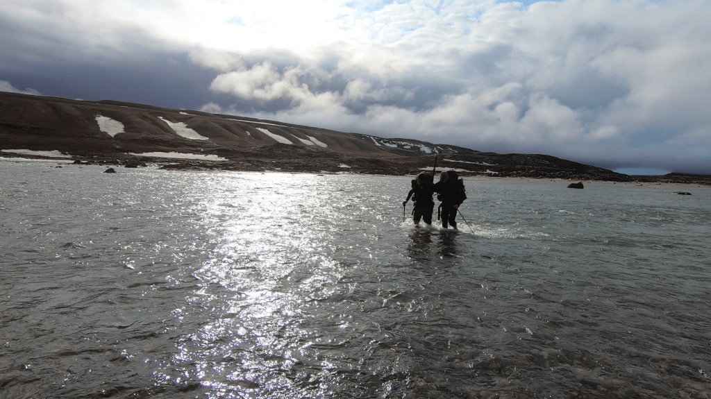
The river looked doable. It stretched out over at least 150 meters and the tide was low. It consisted of two rounds as the river split up into 2 streams as it terminated in the ocean.
We crossed in pairs of 2. Water remained well below our hip and we could easily cross. Though it would have been a whole other story had the river not spread so wide.

As we stood on the other side in the sun we were feeling pretty good about ourselves. We had taken all major obstacles and it looked like nothing could stop us from reaching the Kane basin beyon Kap Inglefield. The fact that we spotted some wolf tracks added to our good mood.
We hiked along the arctic coast through magnificent Tundras with brown mountains east of us. It was easy going, but it had been a long day. So by the time we got to the stream where we wanted to camp we were tired. We set up camp and ate outside for the first time with magnificent views over the ocean. The weather for tomorrow was looking good as well, we were in luck!


Day 9
Our goal for today was to try and get sight of the Kane basin. The large basin between Northern Greenland and Elesmere. One of the northernmost pieces of land on earth.

It was clear that following the coast line was not a a great option. It had been easy going for the last kilometers but the coast further ahead was definitely getting steeper. We decided to follow the stream we were camped at into the side valley next to us. By the look of the satellite imagery and map seemed to indicate that it would take us slowly up to the interior plateau via which we could make our way to the northern coast. I did not even bother checking my inReach, the contour lines on the inReach map were utter gibberish.

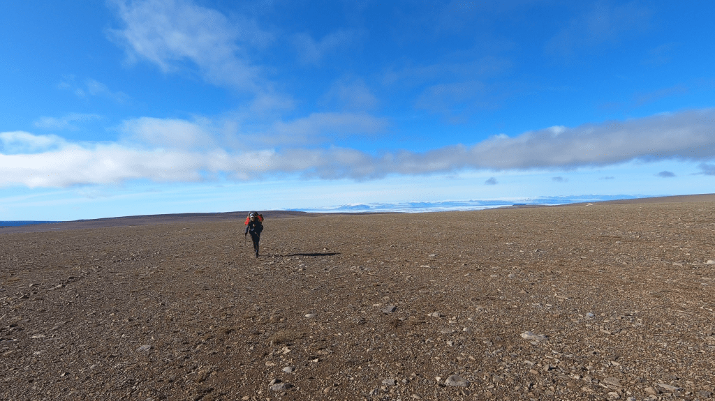
There were some low hanging clouds adding a mysterious atmosphere to the valley we entered. The valley was small and secluded with some small glaciers on both sides, it kind of felt like being in eastern Greenland way further south. It also felt like there would be some pass at the end of the valley. The landscape so far north is simply confusing and unearthly. Because of course their would be no pass, instead the valley sides got lower and lower and the vegetation thinner and thinner till we found ourselves on the interior plateau. A vast gravel plane stretching as far as the eye could see. I joked that it kind of looked like ‘Tibet at the sea side’. There was no detail in the landscape at this point, and we could hike as fast as 5km per hour. There were 2 minor gorges but for the rest it was basically straight ahead.
The weather was beautiful and we were sure to get a nice view over the Kane basin. We did not know how far we wanted to push. Would we climb to one of the larger hills north of us to get a good view? Would we hike all the way to the cliffs terminating in the basin itself?
At the end we hiked till 78.5 degrees north and camped at a high point ridge with a nice view. This was likely the northern most point I would ever reach in my life. The sense of remoteness was enormous. We might very well be the only people to have ever stood on this hill, so vast and empty was the nature around us. East of us we could see the canyon and cape Inglefield, norht of us the great Kane basin and to our south the ice cap. I felt blessed to have reached here. And with this weather! Despite all hardship we had managed to reach this place. We marked it with a giant pile of stone. Our north bound trip was at it’s end it would be solely south bound from this moment on.


Day 10
wow the weather had taken a turn for the worse, it was the north pole after all… It was misty and the wind blew aggressively. We had to take special care not to loose our tents. It was a stark contrast with yesterday. On the up side, for the first time our backpacks started to feel manageable. There was ‘only’ 8 days of food left, which gave a sense of normalcy.

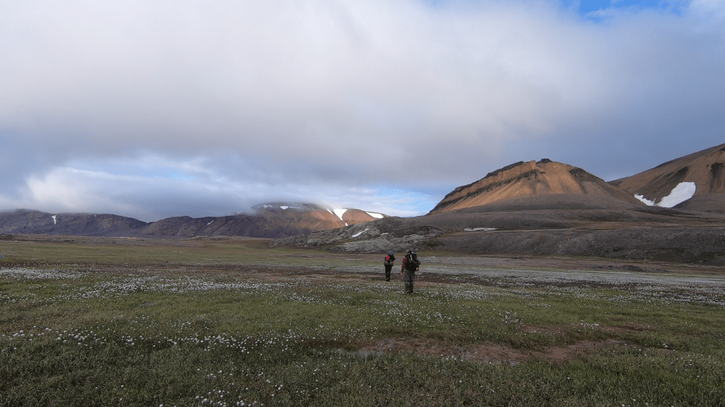
It was cold and windy for most of the day, but as the day progressed we did get better and better views of our surrounding. The rolling landscape around us was vast and colorful in the sunlight. I knew most of Inglefiled land consisted actually not of the coast line valleys we had seen around Etah but this landscape. It truly looked like Tibet on sea level. As we hiked south we saw multiple musk ox herds including one from really up close.
Day 11
It was decision time. There were three options. For our pick up we could go to Etah, Kap Alexander or all the way back to where we were dropped off. We were not looking forward to crossing the ice cap again, so preferable we would head to Etah or cross a few glaciers and head to a beachhead south of Kap Alexander. However the sea was still covered by ice and Saki told me that yesterday the beachhead had been reachable, but that right now it was blocked by a huge piece o ice again.

The last thing I wanted was for Saki not to be able to pick us up so we swallowed the bullet and decided to hike all the way back across the ice cap to the point where we had been initially dropped off. The option of heading to Sioarapaluk went through my head, but that would mean an ice cap crossing of around 50km, that was simply more than I was waiting for.
The plan was to hike along the edge of the ice sheet west ward to a small lake today. We could camp there and dash over the ice cap back to Prudhoe land the next days.
The weather was good and the way without many major obstacles. There were a few streams flowing from the ice sheet we had to cross but the only stream powerful enough to be an obstacle we could simply cross by hiking over the ice sheet for a few hundred meters.
The weather was got better and better. For the first time a real wind still. We could hang around the lake as if it were a beach holiday. It would be our last day in Inglefield land.

Day 12
Fun was over… We had to start our much dreaded way back over the ice cap back to Prudhoe land again… We hoped, almost prayed, that ice conditions would be better this time. Or at the very least not worse.
For the first few kilometers it seemed like we were lucky, but after a while the wet part o the ice sheet unfortunately began. Once again we were wading over a seemingly endless field full of slush.
It took a few hours to cross it and as soon as we made it back to solid ice we set up camp.

At least the weather had been better than last time. We could see the great Humboldt glacier and even the peaks of Washington land far north of us. In our hubris we had decided to go to Nyke instead of the Clemens glacier. Which would be a bit further but give us a different route to try out.
Day 13
It had been a relatively warm night. Which in itself was nice, but the snow conditions were quite terrible. We were just going 2km an hour. As per usual the clouds had set in and everything around us was white. We once again had to rely on our patented rope group gps navigation technique…
The going was so slow that we decided to abort Nyke and head to the Clemens glacier. Anything we could do to traverse fewer snow was perceived a win at this point.
We did not make it a long day and set up camp around 4:30pm. Hopefully the snow conditions would be better the next day.
Day 14
Both the snow and weather had improved a lot during the night. We could make relatively quick progress and it was an amazing feeling when we started to see the first peaks of Prudhoe land. ‘Land in sight!’
As we approached the end of the ice sheet we started to get an amazing wide view over the fjord and mountains. We decided to camp early. We had enough time and wanted to enjoy the vastness of the views. Truly views that I had never seen anywhere else.
The sun was nice and warm and we could sit outside our tents on the ice. Gazing of over the immense distances we could see.


Day 15
We rose early so that we could take advantage of the hard ice of the morning. We hiked down at a high speed through excellent ice and snow. We accedentaly started to descend the Diebietch glacier instead of the Clemens one but fortunately we discovered the mistake soon enough. The Diebietsch glacier was indeed a lot worse than the Clemens one. Saki’s advice to not take the Diebietch glacier had not been overstated.

The way down was just so much easier than the way up of 2 weeks back. We had gravity on our side, good ice conditions, nice weather and light backpacks. We slalomed the crevices with ease, it was nothing like the heavy slug we had last time. Funny enough our footsteps of list time were still visible. It was clear that we had not been able to see around us, it was a weird zigzag trail. As if we had been blindfolded. However looking back it had been a pretty good route, in which we did unknowingly circumvent the worst of the crevices.

Descending further we stumbled on another wolve trail. Apparently wolves do traverse the ice sheet. The Clemens glacier is 12 kilometers long and we did not hike all the way to the sea side. Instead we camped on the lower section. The others went up one of the side slopes for a view of the Diebietsch glacier, but I just relaxed in the sun around the tent for a bit. I felt I deserved it. We had made quite the trip… The last 8km to the coast would be easy, we had made it all the way to the north coast o Inglefield land and back.
Day 16
A rainy day again… But that did not matter. It would not be far and the day of our pick up would be nice and sunny again. So we would be able to enjoy a nice boat trip after all!

We hiked over the broad glacier all the way to the beach, where we camped in the wet sand. Everything was so wet and dirty that I just started to use the stove to heat up the tent. My own polar sauna.
Saki told us that Otto would pick us up tomorrow and that she would message me when he left.
Day 17
The glacier woke me up. Or wait was the rumbling the glacier? I heard it again. No… That is a gun shot. I looked at my Garmin and saw that Saki messaged me that Otto had left earlier than she had thought. Quickly I got out of the tent. It was indeed Otto, I saw him in his boat scouting the coast line. He had not been able to spot us and was firing shots in the hope he would find us.

I quickly got out our rifle to fire a shot. If he left without us it would have been a complete nightmare ;p Luckily he heard my shot and saw us waving.
The way back was really enjoyable. We had no wind or rain this time and we got to enjoy the views from the water. The many birds soaring over the water, the ice bergs and enormous glaciers terminating in the sea.
We made a small stop over in Siorapaluk and then headed back to Qaanaaq.
It was the end of our trek. My first trek in the true high Arctic, maybe the most remote place I will ever be. The flight back went without difficulty. It went slow however. Each time spending the night. Once in Qaanaaq, once in Illulisat, Kangerlusuaq and Copenhagen. The way back was just as the way up a vacation in itself…