

Decenber 2023
Saul – random jungle – Belizon
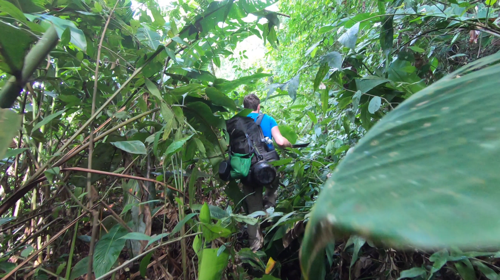
The Amazon rain forest is one of the vastest wilderness areas of our planet. This of course made it a logical target for a trek. The wild rain forest is however not a very trekking friendly place… The vegetation can be dense and by times downright impenetrable. Not to mention the bugs and snakes that need to be dealt with. The fact that I have quite little experience in this type of terrain also contributed to the fact that I had long postponed a trek in this region.
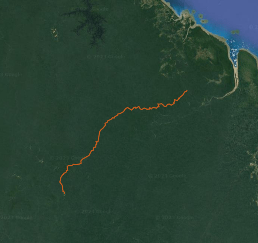
However due to seeing a documentary on an expedition Kayaking trip in Ecuador and the movie about the ‘lost city of Z’ this region of the world got more and more top of mind and I started to investigate my options. My first instinct was a canoe trip. This would make sure we would not get lost (which you can so easily do in the jungle) and could cover a larger distance. I quickly found a nice and remote river suitable for an adventure. The Lucie river in Suriname. There was however no pilot willing to bring me there without a guide and the one touring company organizing trips there charged a whopping 3k per person. With the flight ticket the costs for this trip could easily exceed 4k. For a simple first expedition to the Amazon this was simply not worth it. I therefore looked further and stumbled on a trail on open street map in French Guiana next to Suriname. The route was named ‘piste de Belizon’. It was not indicated on Google Maps, only on Open Street Map. I could not find much information online. There was a blog of one french person who had hiked it in 2003 and 2017 and I understood it was an old gold road that was constructed in 1950 and closed in 1960.
First I wondered whether a road would be interesting enough to walk on, when I found out more I wondered whether the road would at all still be visible and walkable at all…
I doubted for quite some time whether this expedition was feasible till all of a sudden a video of someone name Elliot Weber was posted on Youtube. He had completed the hike the summer before, which gave a lot of confidence. I posted a comment under his video to get in touch. Luckily he was willing to have a phone call with me! Thanks to this I had enough reassurance that the idea was save and feasible enough.
The idea was to fly to Saul, a small village in the middle of French Guiana that is only reachable by plane and hike to Belizon in around 9 days. From Belizon I could use the road to get back to Cayenne. The route went right through pristine forest, mostly old grown and should give us the opportunity to see lots of wildlife. The plan was settled.
Adriaan agreed to join the expedition. He had actually agreed before to the canoe trip in Suriname (as he preferred the canoe above hiking due to his knee injury), but now the canoe trip had been replaced by a hiking trip he decided on going anyway.
With the plan finally completed and vetted we wanted to book our flights, however, the world seemed to keep throwing obstacles at us… AirGuyane, the company providing flights to Saul had gone bankrupt (which I can understand since they flew people there for just 50 euros). At this point our mind was however set on the plan and we decided to just buy our tickets to Cayenne and gamble that flights would be restored before the time we arrived. I mean, people simply cannot reach Saul without these flights, so I guessed they pretty much had to be resumed…
I was correct, but not by a wide margin, just 2 weeks before we arrived a new company named Fly Guyane had resumed flights. Saving our holiday at the last moment.
Videos
Day 1
The flight from Cayenne to Saul was probably already one of the highlights of the trip. From the small airplane we could see the rolling hills of French Guiana covered by an unending green ocean of canopy. There was no ground to be seen, the canopy covered absolutely everything.
Even from the plane the diversity of the trees was clear. We could observe the many different colors and flowers. It was intimidating to realize that we would need to hike our way back through this dense and endless forest. I was wondering whether my Garmin Inreach would work at all under this dense canopy.

The airport in Saul was just a stretch of dirt and we had to offload the luggage from the plane ourselves. It was amazing to arrive here. It really felt as being in the middle of the great Amazon.

We decided to walk to Saul. Our bags were quite heavy, especially regarding the heat and the fact that we had chosen for smaller packs this time around. We would really need to quickly eat or simply drop some food to make this manageable.
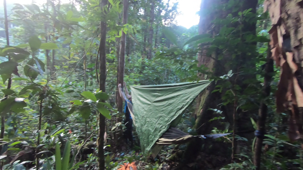
We arrived in the village in no time, we informed for a place to hang our hammock and we were pointed in the right direction. We slept at the edge of town in a really nice hut where we could hang our hammocks. There was a small kitchen, a shower, everything. We also immediately had our first animal spotted. A large Ara parrot right across from us in the tree.
As we settled in we got our first glance of a tropical down poor. We could wash our hair with the water falling off the roof.

We sat down and relaxed, we enjoyed the feeling of being in the middle of the great Amazon, nothing but kilometers of jungle on all sides. I thought back of the endless canopy that we saw from the plane and how it would be to traverse that sea of green in the coming days.
As it got dark we went out for dinner. Rice, beef and a bit of salad. An excellent christmass meal!
Day 2
Our first day on the road. The plan was not to immediately hike towards Belizon, but instead make a side trip to mont Galbao, one of the higher ‘mountains’ around. We had the time and climbing a mountain was something on this trip would add another dimension we thought.
We started on the regular hiking route. Which was due to me still not feeling very well and our very heavy packs actually already quite challenging. We could not wait to reach the point where the layon to mont Galbao would leave the route so that we could make a food drop and leave some of our weight behind.
On the trail we came across an older man who said he had seen a jaguar earlier that day. I really hoped we would get the chance to see one as well… We did not see one that day, but we dit see a Pikari pig not much later. And a few forest devil monkeys during the afternoon break.

We left the majority of our food behind. We immediately felt relieved… The second stage along the Layon de mont Galbao, was a lot more difficult than the route. The trail was only small, and we had to dodge many fallen trees along the way.
It was already getting late in the day and we had to rush the last part to make it to our camping spot before it got dark. We arrived there so thirsty and tired that we decided not to climb the mountain the next day, but instead just head back for our main objective. ‘The piste de Belizon’. We figured that we could climb it, but as everything here was completely overgrown, we would probably hardly notice when we were on top….
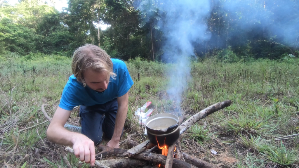
I tried our strategy to create a fire with some candles, but it failed. It had rained an hour earlier and everything was just too damp. We hoped we could make a fire in other places to cook our macroni. Most of the food we had we could just eat without cooking though. This evening we chose to eat our mashed potato powder. The water from the stream was lukewarm so it was actually not that bad. (The one advantage of not being in the polar regions!)
Day 3
We retraced our steps to the “route de bouef mort” where we picked up our luggage again. Something we much dreaded… I threw out half a kg of macroni, but did not dare to dump much more as 10 days is a long time… I suspected that we might eat a lot less than usually as temperatures were so warm, but still we would need quite some provisions for the long way ahead of us.
We followed the route till the place where the piste de Belizons parts to head up north. There was no sign on the cross road. Probably not to raise expectations and discourage people from believing it to be a real route. But thanks to my inReach I was sure it was the correct turn to take.
The route was broad and easy to follow. Adriaan and I were joking amongst eachother that we would reach Belizon in no time this way. I was thinking that maybe because flights had been down for 2 months, people might have opened up the route with quads. It was clear that the route had been used by quads recently. All obstacles were neatly cut away.
We reached our destination of the day in no time. A nice carbet next to the river. It said on a sign that it was private property, but the whole carbet looked very overgrown and abandoned. We decided to just use it.
It was a great place to spent the night. A nice open space, a larger and clean stream and there was potential for a fire. I however did not get a fire going, despite the amount of dry wood and the candles I brought, I did not get it going. Luckily Adriaan had a fireplace at his home and could use his skill to get us a nice fire. His trick was to very slowly burn thing leaf for leaf and twig for twig to get it going. My usual technique to make a pile with bigger wood stacked on smaller twigs, did not work. Usually it is quite effective, but I missed the benzine that I usually carry to get it going. We decided to cook much of our macaroni that night as we could not be sure how often we would be easy to light a fire in the coming days.

The route seemed to get worse after the carbet so I decided to checkout the route ahead. After crossing a few obstacles it seemed the route looked good again so I quickly turned back. I did get to see a large yelowish turtle, the first sight of an animal along the piste de Belizon. I was curious what other wildlife was awaiting us.
Day 4
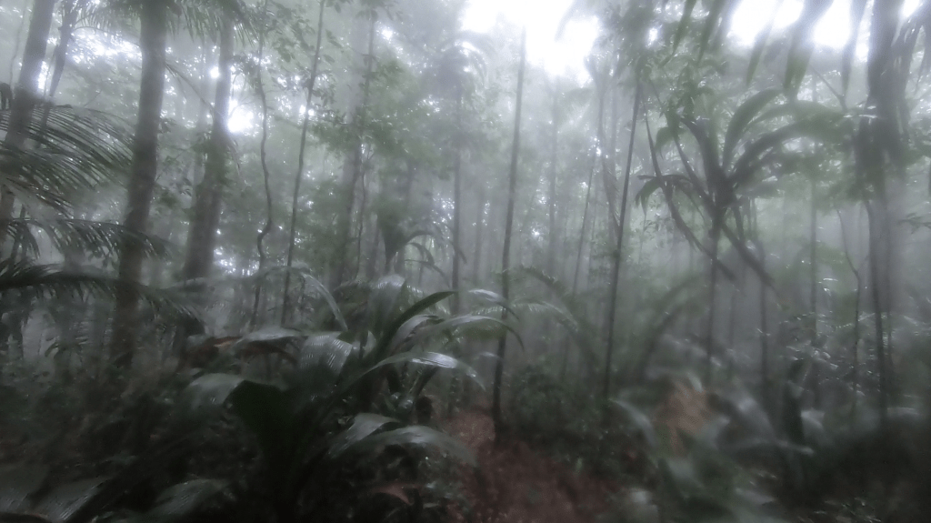
This would be the first real day along the piste de Belizon. It started out easy. Like really easy. Every hour I felt more encouraged that the route might be in good conditions all the way. However, when we got to the first stream crossing the easy road all of a sudden stopped and made way for a pretty overgrown track. The change was so abrupt that we lost the route for a moment. We did not see the route continuing on the other side and followed the western bank of the river a while, but that went nowhere. Adriaan in the end spotted the road on the other bank. As we crossed and followed it it took a while before I felt confident that this was indeed the route. The change between an nice road suitable for quads to an overgrown jungle track was so sudden that it took some time to adapt.
It was clear. No quads had been used to reach Cayenne during the downtime of the flights…
We arrived in Agami early in the day. Agami was a larger open space from where the route split. According to my route description we had to take the one to the right, which was also visibly the more open one.
The day had been dry the entire day for the first time and we arrived early, so once again we could make a nice fire.
Day 5
I had chosen to hike from Saul to Belizon instead of the other way around, because I know that the toughest section would be the stretch between Agami and Bagdad. I figured that it would be best to face that section at a point where returning was still an easy option. From the videos I saw from Elliot I know the trail could get pretty overgrown here. He referred to it as the “green inferno”. Today we would get a taste of that.
It started out easy, but later in the day we could really put our machetes to work. In some places it was hard to imagine how one would get trough without a machete.
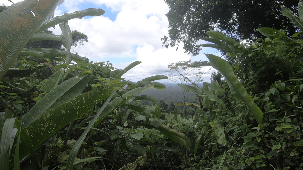
In the middle of the day, during the most difficult section we were rewarded by some amazing views. We found ourselves on a very steep ridge and for the first and only time in our entire trek the trees gave way and showed us the vast surroundings in which we found ourselves. We could see what must have been millions of trees covering the rolling hills of the Guyanese heartland.
I recognized the place from Elliot’s footage. I knew that this meant that we had the hardest sections of the trail already behind us. Whatever would come next would be at most just as hard if conditions had not changed too much in the year and a half that he had been here (which is admittedly quite an assumption)
It was a long day across hilly landscape with few water sources. We were forced to make a long day all the way to Bamboula, the first place with a creek. We only arrived at 5:30 just 30 minutes before sunset. Giving us just enough time to take a bath and cool down in the stream and setup our hammocks.
We could have been there at 5, but according to my GPS the actual camping spot should actually be 800m further. We continued on, but the coordinates seemed to be off. wasting us another 30minutes…
Setting up camps was a bit harder than I had thought. Sure there were enough trees, but you did have to cut an open place to be able to hang an hammock. And the spacing had to be just right.
We had not much time for supper and were eager to get in our hammocks to avoid the mosquitoes which seemed to be most active during the night and morning time. The jungle with it’s short days and many insects don’t give you much rest. That and the heat would probably be the biggest reasons why we ate so little that day without feeling too hungry. Not feeling the need to eat much would be a common theme during the trek.
Day 6
According to my route description today would be another mountainous day with little water. We made sure to fill up and hoped for easier trails ahead of us.
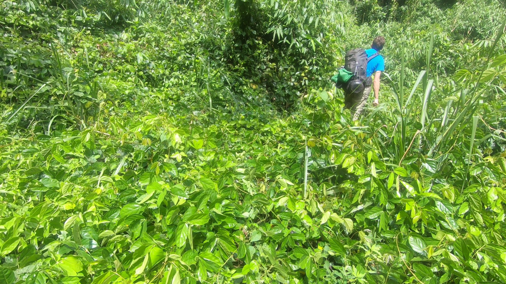
The trails was a tad easier than the day before, but definitely not a stroll. We were constantly thinking about how many fallen trees we would have climbed over or hiked around by the time we reached Belizon. Would it be 2000? Or more like 900? There seemed to be no end to it. The other major obstacle were the open places. Which arguably were even worse. When the sunlight could touch the ground the shrubs and plants grew thick and we had to chop our way through.
We kept our eyes open for Jaguars, according to my information the Jaguar population around Bagdad was quite dense.
Our half way point was a small open space with a stream. In the evening it might be nice here, but during the afternoon the scorching sun made it a hell… It is in these open spaces that you always need to try and find the correct way again. Chopping your way through the dense shrubs in the hot sun without a guarantee that you are heading in the right direction is quite heavy on the mind.

It would likely be the last water source till Bagdad so we had to fill our bottles. Our water filter had already broken down. Due to the amount of sand the pumping had gotten heavier and heavier till the pump just broke under the force we had to apply. By now it took around 800 pumps to get a liter of water. It took ages in the sun to get our water filled up. I was pretty angry with myself that I had not brought any alternative purifying means. I literally had the exact same problem during one of my first treks in India. Had I not learnt from that?
We arrived in Bagdad a lot earlier that we had in Bamboula the day before. Mostly because we had managed to leave earlier. It was quite a nice campsite. The only downside was that the water was not bathable as there were no rocks.
We though about how things here got there name. Why were these open spaces in the forest named things like Agami, Venise and Bagdad? Tomorrow we would head to a place called Ouragan. Where did these names originate from? Why even giving these places a name? There was nothing else than a creek to be found.
Day 7
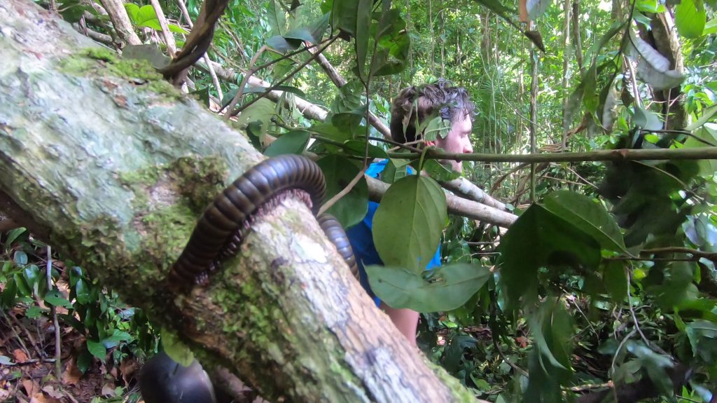
Today we saw a snake again. Last evening had not been an exception, they are definitely around. Snakes are the animals I’m most afraid off. If a poisonous would bite us, realistically, our chances of living to tell the tale would be rather limited. Help was far away, the connection from my inReach poor and the places where a helicopter could land were few and far in between. I hoped it would be the last snake we saw, even though this particular small and timid snake did not seem threatening at all, we knew the jungle had way worse to offer.
Apart from some open spaces and fallen trees we had to cut through the route was getting easier. This was a good thing Ouragan was around 13km bird flight, a lot further than the distance we had to cover the days before.

In the end we did not hike all the way to Ouragan, we stopped 800 meters earlier at a small creek. I had learnt my lesson from the day before and did not feel like pushing on a little further just to find no or an inferior water source. These small jungle creeks were actually a lot nicer than the larger ones on the open spaces. Instead of being swampy they have rocks and solid ground. And best of all, we could tap our water without having to stand in the tropic sun.
Late in the afternoon we monkeys right above the route, the best sighting we had had so far. They were clearly challenging us. Looking us right in the eye and dropping large sticks down.
We started to get more used to our jungle environment and felt a lot more at ease. We went to bed after dark and thought of the innovation to pump our water in the evening and eat breakfast from our hammocks. In the morning the stinging moths were out. Their sting was not that painful, but their zooming made them definitely one of the most annoying insects we had to deal with. Only the ticks overtook them on the annoyance leader board. At this point we had to remove between 12 and 20 ticks each day, they were unstoppable.
It would be new year tonight, but neither of us was willing or able to stay awake. We wished the animals around us a happy new year and fell asleep. The jungle at night is so loud that you could just as well imagine that all animals are having a new year’s party. Especially the frogs were having a really good time.
Day 8
Accourding to our route description the next stop would be Yolande. But that was 18km away. Almost double the distance we had done till now. 15km, maybe, but 18 just sounded unrealistic. We decided to just start early and see where we got. Maybe the trail would get much easier from this moment on?
As the day progressed we realized that the 18km was completely unfeasible. The route was definitely not getting much easier…
There had been many honey birds our entire trek, but this day we truly saw a great number of them, in all kinds of shapes and colors. They were easily noticed as they zoomed as a giant bee. They were not shy, but due to their high speed and unpredictable flight path we simply did not get one on camera.
The deepest point of the day was without question the moment that Adriaan chopped with his machete right into a wasp nest. He had to cut through some high grass and at just one wrong chop dozens of wasps rose from the grass and attacked him. He ran ahead, right through the thorny shrubs. He ran cursing for about 50 meters by which time the wasps had lost track of him. I had been just behind and the wasps to my amazement just left me be. I retraced my steps back and went for an alternative route after which I met up with a bleeding and red Adriaan. He had run full of adrenaline through the shrubs and had cut himself in many places. It was not too bad though and he could already laugh about it.

Not much later Adriaan also stumbled on a small brownish snake. This time it did not fled as the ones before it had done. Instead it just moved out of the way and sissed aggressively to Adriaan. He had by that time already past it. He warned me and I take a detour around it while Adriaan kept his eye sharp on the snake. If the snake felt it could be so aggressive it probably was not to be trifled with.
Adriaan joked that bad luck just kept striking as long as he was in front. When I was ahead however we stumbled on a Jaguar that probably had been sleeping right next to the route. As we approached I was it running away. This day really was the day that all dangerous animals presented themselves…

We got to the midway point Venise rather early in the day. At 4:30pm. Pushing on to Yolande was out of the question and we decided to set up camp at Venise and relax. It was a pretty nice spot and it was clear others had camped here before us. A creek with rocks, excellent for bathing.
Day 9
Belizon no longer felt that far away. At last we were getting somewhere! The landscape also started to flatten out and the route got easier. Even though the hills were not as high as they used to, there was still a lot op up and down. Just in more rapid succession then the days before.

We saw another large turtle and a bird of prey. For the rest not that much happened today. Though something very significant did not happen. With Adriaan having chopped down a wasp nest I was extra alert and spotted a small wasp nest in front of us just in time. I touched it with my machete to test it out. Immediately wasps started to come out. That was a nice bullet to have dodged…

We reached our end point Yolande early in the day. It was however a messy swamp with a creek unsuitable for bathing. Adriaan advocated to just keep on hiking. Yolande was according to him that daughter in the family everyone always dreaded when she was coming over for christmass. I also felt for pushing a bit further on. I wanted to reach Belizon january 5 latest, as I wanted to keep a day in reserve to arrange the pick up.
We headed further for another 2 hours over an easy trail. Of course there was no real creek in sight… During this trek there had been enough creeks to comfortable have sufficient water, but most of the time we had to walk several hours to reach one. They were several hours apart.
At the first place we saw a small stream we immediately set up camp. The stream was however small and the water did not look all that great. We ended up not drinking from it and just using the water we had taken from Yolande.
Day 10
After hiking for just 30 minutes the route did something unexpected. It seemed to split. There were 2 directions in which one could go. That did not make any sense and it worried me a little. One o the routes seemed to go back the way we came. I switched on my inReach and tried that route first. The route followed the line of the piste de Belizon on my inReach exactly. But exactly in the wrong direction. I figured this was the piste de Belizon, but in the wrong direction. The route must have split some place before and we probably had not noticed it. The route was not splitting, but two alternatives to the piste de Belizon were probably merging back together.
When we tried the other route it did diverge from the route on my inReach, but not by a wide margin. We kept following it. The route on my inReach went right through the reserve ‘de Nourages’ the route we were on followed the exact edge of this reserve. This in my mind made sense and I felt a bit more comfortable. Hopefully this splitting would not happen too often.
The trail was pretty broad and felt quite recently dug out. The route did have a lot of steep ups and downs however. Luckily it was cloude or we might have gotten pretty thirsty. At this point our water was empty as we had made a dry camp the day before.
Around 10 am we could refill our bottles and continue our way. We were really getting sick of our slow working pump. We dreamt of far away places where one could drink water directly from a tap.
It was not long or we made it to Rubis another open space. As we arrived we saw two very large Iguanas, at least a meter long, running away from us into the shrubs. Another wildlife count!
I felt happy and relaxed to arrive in Rubis. It meant that we could now be truly sure we had chosen the correct route and that we would be able to make it to Domremy with ease.

We took a long break to pump water and observe the working ants around us. The ants were constantly scouting the area. Everything that fell down was immediately spotted and taken towards the nest. When I splet an annoying mosquitoe that was bothering me it was immediately detected, slowly but steadily it was dragged over the rock to the nest.
Domremy, where we set up camp, was a really great place. The best camping spot we had had the entire trek. The creek was large and deep enough to swim in and it had a small waterfall. The trees were very suitable for our hammocks and we could hang them right next to the creek. We might have made a dry camp the day before, but being able to arrive here early made it worth it.
Day 11
This would be the last day. When we left Saul behind, Belizon seemed so far away, it was hard to imagine us ever getting there. But now it said only 13km more to the Carbet Militair. That was close. really close. Now I knew that from the carbet onwards we would still need to cross the river and follow the road a while, but still we were getting real close now.
It was our last day, but the jungle still had a nice day in stock or us. We got to see lots of birds and monkeys. We also got to see a Toucan, which was high on our list! We also saw a Capibara, I think I had already seen one slipping away in the corner of my eye, but this time it was a clear sighting. At the very end of the day, when we already crossed the Comte river and were hiking on the road and were not expecting to seen anything new, we saw 2 ant eaters slowly crossing the road ahead of us. This was probably my favourite sighting of the trek. They moved slowly and they looked just so peculiar.
Today was the first rainy day since we had departed towards Belizon. There were multiple heavy rains. On any other trek this would be a bad thing, but here it was a welcome relief to ease the heat.
The day was however not without worries, at the open space Brodel the route was not that clear and when we found the route again it seemed to go real off track. I kept looking at my inReach but we just went further and further from the indicated route. Now I knew the route at this point was updated and I decided to focus on our relative position to the carbet militair instead. This was a point of which I was sure we would pass.
The distance between carbet militair was stable, we did not get closer and we did not get further away. I kept looking at my inReach, praying the trail would make a sudden turn towards it. This went on for actually several kilometers, but then the route decisively turned towards carbet militair. Every step was now a step closer.
We took a small lunch stop and reached the carbet not much later. That was it, we were there… We made it! It was a really nice hut to spent the night. But we did not have the time, our plane would leave the day after tomorrow and I did not want to cut it that close.
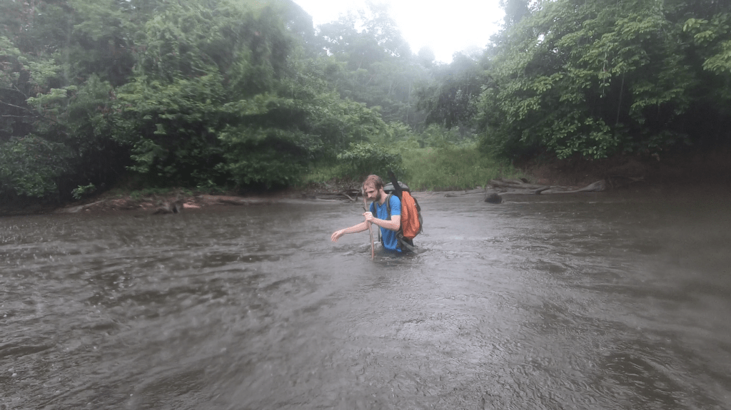
The last thing we had to do before reaching a, somewhat, motorable road was crossing the Comte river. Usually this can be quite an obstacle, but even though the rain was pooring down at this point the 7 days of drought made the crossing child’s play.
On the other side of the river there was a small ‘road’ of which it was clear that it had been used by quads not that long ago. It was now a question to keep following the road till we found people.
As we continued the road got larger. The way was however still not easy going as it went steep up. It was not a real road yet, more a quad track. To my surprise and delight we got to see 2 ant eaters crossing the road! It was the animal I wanted to see most. It are such wondrous creatures. We got to see millions of ants, but no trace of an ant eater and I had given up, but here on the final meters of our trek we still got to see them.

As we pushed further on the quad track became a dirt road. There were cut logs next to the road everywhere. But where were the people? There were tire tracks and we thought we heard the sounds of generators in the distance, yet we did not see anyone.
I had hoped to run into someone at this point… To make things worse the road kept on splitting, making it hard to see which one was the main track. It would not happen that we got this far and then got lost in logging tracks in the last few kilometers…
I messaged our family home for coordinates of the carbet Rosette and carbet Grillon. I had not saved these waypoints in my gps as I assumed we would find gold diggers in this are, but I was wrong. The route on my inReach should guide us to these carbets, but the route on my inReach also kept splitting up, with the main road over 35km away it was hard to see which route was the correct one.
I received the coordinates of the carbet Grillon from my mother, now at least I could make out the correct using my inReach. It was however getting dark, we were out of water and the inReach only had 8 percent battery left. So it was not going as well as I had hoped…
As it was getting dark we hiked and hiked. The road was winding, at one point we had to hike a loop of 3km just to gain 300 meters. I had already lost hope to find people today and was starting to lose hope to find the carbet Rosette. I guess we would just need to find a stream and hang our hammocks next to the road.
Long after it had gotten dark we finally reached a small stream. We looked around for a place to hang our hammocks. And then we saw… The carbet Rosette! So it was there after all. We were happy that we could at least sleep in a carbet tonight. We were tired and immediately hung our hammocks and went to sleep.
After 30 minutes I however started to realise that I was simply too thirsty to sleep. Sick and absolutely tired of pumping I made a fire with the leftover wood and cooked us some soup.
Late at night between midnight and 1am I saw a car drive by. I was already in my hammock and could not hail it, but it was there. Maybe we could hitch a ride tomorrow. God I hoped we could hitch a ride tomorrow…
Day 12
We woke early. If we had bad luck we might need to hike all the way to carbet Grillon, which was quite some way to go.
As we packed up we heard another car! This time we could hail it. It were 5 hunters (that in their pick up truck kind of looked like a militia). They were actually going to stay overnight in the carbet Rosette to hunt in the surrounding. They were pretty impressed with the trek we had made so far and offered us some coke and water. Especially the water was more than welcome! It would get hot today, and both of us were done with pumping our asses off for a few milliliters. As soon as I reached civilization I vowed to immediately throw our bloody water filter away.
As we hiked on we saw another quad, again in the wrong direction. Darn… Why was all traffic going the wrong way…
Only later in the day there was a car, again going in the opposite direction that we could hail. They were gold diggers and we had a small chat. Once they learnt we had hiked here from Saul there interest got peaked. They offered us to take us to their mine. I explained we had to go the other way as we HAD to be picked up tomorrow at 11am. He told us that we could go with him and he would bring us to the road head again. He said that he had water, lunch and internet at his site. This was an offer we could not refuse. And so we got in the car and drove in about half an hour all the way back to where we were yesterday in the afternoon… We had hiked for hours today and for hours yesterday evening, and in just 30 minutes we were back where we were. Worse, it turned out that we had been close to people all along. All we should have done was straying from the main road and we would have found a mining camp…

Once at the mining camp we finally got our well deserved rest. No more hiking this holiday! We had lunch and contacted our travel agent in Cayenne for the pickup. Our Belizon expedition had gotten to an end.
